Tropical Depression Luis Soaks Bicol and Luzon as PAGASA Watches for Possible Upgrade to Tropical Storm
ORBIS WEATHER — August 2, 2026
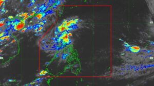
Tropical Depression Luis is crawling across the Philippine Sea east of Luzon on Sunday, dumping moderate to heavy rain on the Bicol Region and prompting the Philippine weather bureau PAGASA to keep the country’s lowest wind signal in place while it watches for a possible upgrade to tropical storm strength within the next day.
As of PAGASA’s 10 a.m. bulletin, Luis was centered about 400 kilometers east of Infanta, Quezon, with the system’s position later placed roughly 285 kilometers east of Baler, Aurora, by the afternoon update. The depression has maximum sustained winds of 55 km/h near the center, gusts of up to 70 km/h, and a central pressure of 1,002 hectopascals, and it has been crawling northwestward at only about 15 km/h. PAGASA has kept Tropical Cyclone Wind Signal No. 1 in effect over the Polillo Islands, Camarines Norte, northern Camarines Sur — including the towns of Caramoan, Garchitorena, Lagonoy, Tinambac and Siruma — and northern Catanduanes, covering Pandan, Caramoran, Bagamanoc, Panganiban and Viga, warning residents there to expect winds of 39 to 61 km/h within 36 hours. Forecasters have not ruled out raising Signal No. 2 in parts of Luzon if Luis continues to strengthen.
PAGASA’s forecast track calls for Luis to keep moving generally northwestward for roughly the next 12 to 24 hours before curving toward the east-northeast, a turn that would keep the storm’s center out over the Philippine Sea rather than crossing land. Forecasters caution, however, that “a westward shift in the forecast track could still bring the cyclone closer to or result in landfall over Northern or Central Luzon,” meaning the threat to the mainland has not been fully ruled out even as the most likely scenario keeps Luis offshore. The agency expects Luis to strengthen into a tropical storm within about 24 hours before the system weakens again, ultimately degenerating into a remnant low-pressure area by around Wednesday, August 5, and potentially being absorbed into the far larger circulation of Super Typhoon Dolphin, the powerful system churning in the open Pacific well to the east.
Rain, rather than wind, is the dominant hazard tied to Luis for now. PAGASA has warned of moderate to heavy rainfall capable of triggering flash floods and landslides across Isabela, Quirino, Aurora, Quezon, Camarines Norte, Camarines Sur and Catanduanes, with light to moderate rain and occasional heavy downpours extending into Metro Manila, the Ilocos Region, the Cordillera Administrative Region, Cagayan Valley, Central Luzon and other nearby areas through at least Tuesday, August 4. Coastal waters off northern Camarines Norte, Camarines Sur and Catanduanes are expected to turn moderate to rough, with wave heights reaching up to 2.5 meters, a hazard for small fishing boats and inter-island vessels. Compounding the rain risk, forecasters note that the seasonal southwest monsoon, or “habagat,” is being separately enhanced by the sheer size of Super Typhoon Dolphin far to the east, adding another layer of moisture over parts of Luzon even though that larger storm remains well outside the Philippine Area of Responsibility.
Luis is one of two systems Philippine and regional forecasters are tracking this weekend, the other being Super Typhoon Dolphin, a historically powerful cyclone that reached Category 5-equivalent strength over the open Pacific before beginning a gradual weakening trend as it tracks toward Japan’s Ogasawara Islands and, potentially, the waters near Okinawa later this week. PAGASA has said it cannot rule out Dolphin eventually clipping the northeastern edge of the Philippine Area of Responsibility, where it would be given the local name “Maymay,” though the more immediate and direct impact on the Philippines continues to come from the much smaller, slower-moving Luis.
Residents of the Bicol Region, Polillo Islands and Catanduanes should keep monitoring PAGASA’s updates through the day, secure loose outdoor materials, and be prepared for the possibility of flash flooding or landslides in low-lying and mountainous areas as rain accumulates. Fisherfolk and operators of small vessels are advised to avoid coastal waters where seas are expected to turn rough. PAGASA is expected to issue updated bulletins every few hours as Luis’s track and intensity become clearer, and Orbis Weather will continue following the storm’s progress.
Sources
This report was compiled from publicly available reporting for illustrative branding purposes under the Orbis Weather name. It is not an official product of PAGASA, the Joint Typhoon Warning Center, the Japan Meteorological Agency, or NOAA. Readers should consult PAGASA directly for official advisories, warnings, and forecasts.