
🌋 Indonesia’s Mount Sinabung Erupts, Sending Ash More Than Two Miles Into the Sky
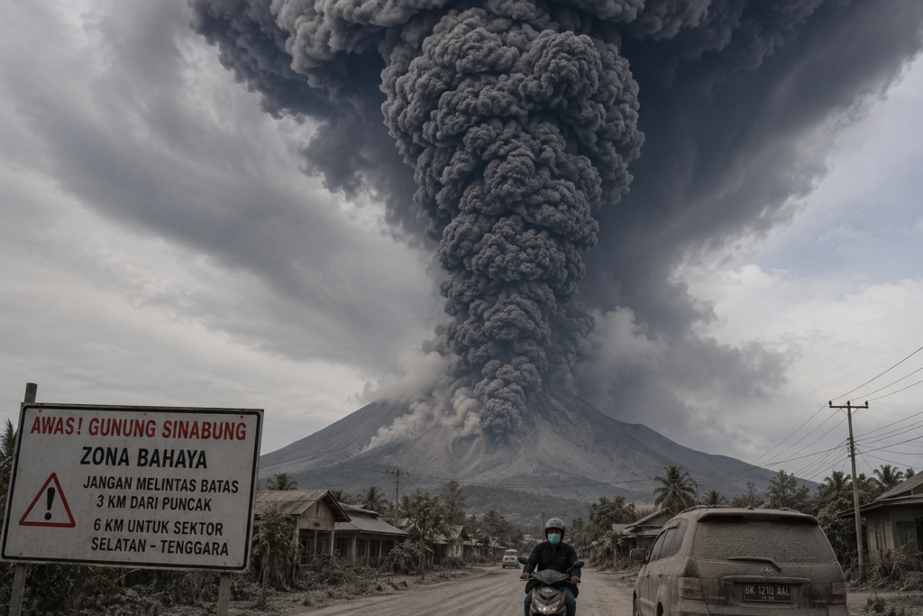
KARO, Indonesia — August 31, 2026 — Indonesia’s Mount Sinabung erupted Monday morning in a powerful blast that sent a towering column of thick black volcanic ash approximately 3.5 kilometers (11,500 feet) above the summit, prompting authorities to raise the volcano’s alert status and warn that an even larger eruption remains possible. (geologi.esdm.go.id)


🚨 Alert Level Raised After Major Eruption
Indonesia’s Geological Agency reported that the eruption began at approximately 10:17 a.m. local time on August 31. A dense black ash column climbed roughly 3,500 meters above Sinabung’s summit, reaching an altitude of about 5,960 meters (19,550 feet) above sea level.
The ash was observed drifting primarily east and southeast, spreading volcanic material toward communities in North Sumatra’s Karo Regency. (geologi.esdm.go.id)
Following the eruption, authorities raised Sinabung from Level II (Waspada) to Level III (Siaga), the second-highest level on Indonesia’s four-tier volcanic alert system. The change took effect at 12:30 p.m. local time. (geologi.esdm.go.id)
⚠️ Scientists Warn a Larger Eruption Could Follow
Perhaps the most concerning development is the warning from Indonesia’s Geological Agency that Monday’s event may represent only the beginning of a new eruptive phase.
Officials described it as an initial eruption and said the possibility of a larger eruption cannot be ruled out. (geologi.esdm.go.id)
There were clear warning signs before the blast. Authorities recorded a sequence including 85 volcanic earthquakes, one emission-related earthquake and one harmonic tremor before the eruption began. Monitoring throughout August had already detected increasing volcanic seismicity. (geologi.esdm.go.id)
🌫️ Ash Blankets Communities
Ash from Sinabung coated roads, vehicles and buildings in nearby communities, while authorities distributed protective masks to residents exposed to the fallout. Indonesia’s disaster agency said ash was moving toward the east-southeast, including in the direction of Berastagi. (bnpb.go.id)
As of the latest reports Monday, no confirmed deaths had been reported, and there were no immediate reports of significant flight disruptions. Officials were continuing to assess the eruption’s impacts. (apnews.com)
🚧 Expanded Danger Zone
With Sinabung now at Level III, authorities are urging residents, tourists and visitors to remain outside designated danger areas.
People should stay at least 3 kilometers (1.9 miles) from the summit, with the exclusion zone extending to 6 kilometers (3.7 miles) in the south-to-southeast sector. Residents near rivers originating on Sinabung have also been warned about the possibility of lahars, particularly if heavy rainfall remobilizes volcanic ash and debris. (geologi.esdm.go.id)
🌋 Sinabung Had Been Showing Signs of Awakening
Monday’s eruption did not come entirely without warning.
During August, monitoring instruments recorded increasing numbers of deep volcanic earthquakes along with low-frequency and hybrid seismic events. Volcanic emissions had also become denser, at times rising as much as 1 kilometer above the summit. (volcano.si.edu)
The dramatic eruption on August 31 marks a significant escalation.
🔴 What to Watch Next
The key concern now is whether magma continues moving toward the surface and produces another, potentially stronger eruption. Authorities are closely monitoring seismic activity, ash emissions and other changes at the volcano.
For communities surrounding Sinabung, the immediate hazards include additional explosive eruptions, heavy ashfall, volcanic debris and rain-triggered lahars.
With officials explicitly warning that a larger eruption remains possible, Mount Sinabung is once again one of Indonesia’s volcanoes requiring close attention. (geologi.esdm.go.id)