🌀 Gulf Development Area Returns — NHC Raises 7-Day Formation Chance to 30% in Southwestern Gulf
ORBIS WEATHER — Sunday, October 4, 2026
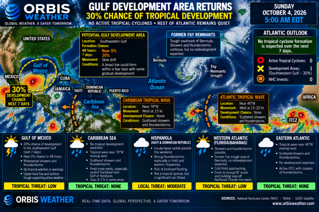
The Atlantic basin has a new area to watch Sunday morning. The latest 2:00 a.m. EDT Tropical Weather Outlook from the National Hurricane Center says a broad area of low pressure could form within the next few days over the southwestern Gulf, where gradual tropical development may then occur. National Hurricane Center
NHC has raised the system’s seven-day formation probability to 30%, up from 20% Saturday evening. Development during the next 48 hours remains near zero because the low has not yet consolidated. National Hurricane Center
There are no active tropical cyclones anywhere in the Atlantic basin this morning, and no tropical storm or hurricane watches or warnings are in effect. Two tropical waves—one near 46°W in the central tropical Atlantic and another near 78°W in the Caribbean—are also being tracked, but neither has an official NHC formation probability. National Hurricane Center
🟡 Southwestern Gulf — 30% Development Chance
This is now the only NHC-designated tropical development area in the Atlantic basin.
NHC says:
📍 Area: Southwestern Gulf
🌀 Current system: Broad low has not yet fully formed
⏱️ Formation chance through 48 hours: Near 0% — Low
📅 Formation chance through 7 days: 30% — Low
➡️ Expected motion: Slow drift over the southwestern Gulf
⚠️ Tropical watches/warnings: None. National Hurricane Center
ORBIS STATUS: 🟡 WATCHING FOR DEVELOPMENT
The important point is that there is not currently a tropical depression or tropical storm in the Gulf.
NHC expects a broad area of low pressure to form in the coming days. Only after that occurs could the circulation potentially begin organizing.
📈 Development Odds Increase Overnight
The southwestern Gulf was not even highlighted in Saturday afternoon’s NHC outlook, which said no tropical cyclone formation was expected during the following seven days. National Hurricane Center
By 8:00 p.m. EDT Saturday, NHC had introduced the area with a:
By 2:00 a.m. EDT Sunday, that probability had increased to:
The 48-hour probability remains near zero.
That evolution suggests the potential window for organization is expected later in the forecast period rather than today or Monday.
🌊 Southwestern Gulf — What Happens Next?
The official NHC outlook says a broad low could form within a few days and subsequently drift across the southwestern Gulf.
Some slow development would then be possible. National Hurricane Center
For now, however, the system lacks a well-defined tropical circulation.
That distinction matters:
Official NHC forecast
A broad low may form, with a 30% chance of becoming a tropical cyclone within seven days.
Not an official forecast
A tropical storm or hurricane making landfall somewhere along the Gulf Coast.
NHC has issued no track forecast, intensity forecast or forecast cone because a tropical cyclone does not yet exist.
⛈️ Gulf Already Unsettled
Even without a tropical cyclone, the Gulf atmosphere remains active.
The latest NHC analysis shows an upper-level low over the southern Gulf helping support unsettled weather, while the broader pressure pattern is expected to evolve over the next several days.
NHC’s high-seas forecast currently contains no tropical storm or hurricane warnings anywhere in the Atlantic basin. National Hurricane Center
The forecast does call for northerly winds of approximately 20–25 kt near portions of the western Gulf and Veracruz coast during the next couple of days. National Hurricane Center
ORBIS STATUS: 🟡 TROPICAL MONITORING / 🟡 MARINE WEATHER
🌴 Caribbean Tropical Wave — Near 78°W
A tropical wave continues westward across the central Caribbean.
NHC’s 6:15 UTC Sunday Tropical Weather Discussion places the wave near:
📍 78°W south of 20°N
The wave is helping enhance thunderstorm activity over the south-central Caribbean.
Development Status
NHC development area: No
Invest: None highlighted
48-hour probability: None assigned
7-day probability: None assigned
ORBIS STATUS: 🟢 NO ORGANIZED DEVELOPMENT
The wave should continue westward toward the western Caribbean and eventually Central America.
🌬️ Caribbean Trade Winds Continue
Weak ridging over the western Atlantic will maintain moderate to fresh east-to-southeast winds across the northwestern and central Caribbean through Tuesday morning. National Hurricane Center
Fresh winds should persist longer through the Gulf of Honduras, while fresh to strong winds may pulse at night offshore Colombia and around the Gulf of Venezuela through Monday.
Afterward, a cold front moving through waters north of the Caribbean should weaken the pressure gradient.
That should leave mainly gentle to moderate winds across much of the basin. National Hurricane Center
ORBIS STATUS: 🟢 TROPICAL / 🟡 LOCALLY BREEZY MARINE CONDITIONS
🌍 Central Atlantic Tropical Wave — Near 46°W
Another tropical wave is moving west across the central tropical Atlantic.
NHC places the wave axis near:
📍 46°W south of 20°N
➡️ Movement: West at 15–20 kt / roughly 17–23 mph. National Hurricane Center
A fairly broad area of thunderstorms accompanies the wave.
NHC reports scattered moderate to isolated strong convection from approximately:
Despite that thunderstorm activity, this wave is not included in the Tropical Weather Outlook as a development area.
Development Status
48-hour probability: None assigned
7-day probability: None assigned
NHC invest: None highlighted
ORBIS STATUS: 🟢 ROUTINE MONITORING
🌊 Tropical Wave Could Produce Rougher Seas
NHC’s latest high-seas forecast indicates that as the central Atlantic wave approaches approximately 54°W, easterly winds could increase to:
💨 20–30 kt
with significant seas around:
Those conditions should subsequently improve as the wave moves farther west.
This is primarily a marine hazard, not evidence that a tropical cyclone is forming.
🇵🇷 Lesser Antilles — Wave Approaching
The tropical wave near 46°W is progressing westward toward the Lesser Antilles.
At its current speed, moisture and thunderstorms associated with the wave will gradually approach the tropical western Atlantic.
Marine interests and residents across the islands should therefore monitor local forecasts for changes in rainfall and thunderstorm coverage.
At present, however:
NHC has assigned the wave no tropical cyclone formation probability.
🇧🇸 Bahamas & Western Atlantic — Cold Front Approaching
The western Atlantic remains free of tropical cyclone development, but a significant non-tropical marine pattern is developing.
Weak high pressure extending from Bermuda toward the Carolinas should shift east through Monday as a cold front approaches the southeastern United States. National Hurricane Center
The front should briefly stall offshore northeastern Florida before merging with another trailing front.
Behind it, NHC expects:
💨 Fresh to strong northeast winds
and
🌊 Rough seas
near offshore waters of northeastern Florida through Wednesday. National Hurricane Center
⚠️ Northeast Florida Waters — Seas Could Reach 11 Feet
Marine conditions could become considerably rougher early this week.
NHC’s latest offshore forecast calls for seas off northeastern Florida to build to approximately:
🌊 6–9 feet Tuesday
and potentially:
🌊 7–11 feet Tuesday night
with northeast winds around 20–25 kt in portions of the region. National Hurricane Center
This will be associated with the cold front and strong high pressure—not a tropical cyclone.
ORBIS STATUS: 🟡 MARINE HAZARD
🌍 Eastern Atlantic — No Development Areas
The eastern tropical Atlantic remains active with the usual monsoon-trough and ITCZ thunderstorms, but there are currently no NHC development areas east of the central Atlantic wave.
No tropical depression or organized disturbance has been designated near the Cabo Verde Islands or West African coast.
ORBIS STATUS: 🟢 QUIET
📊 ORBIS ATLANTIC STATUS — OCTOBER 4
| System / Region | Current Status | Official NHC Outlook |
|---|
| 🟡 Southwestern Gulf | Broad low may form | Near 0% / 30% |
| 🌍 Wave near 46°W | Moving W 15–20 kt | No probability assigned |
| 🌴 Wave near 78°W | Moving W ~15 kt | No probability assigned |
| 🌴 Caribbean | Trade winds / storms | No development area |
| 🇧🇸 Western Atlantic | Cold front approaching | Non-tropical |
| 🌊 NE Florida offshore | Rough seas developing | Marine hazard |
| 🌀 Active tropical cyclones | 0 | — |
| 🟠 NHC development areas | 1 | Southwestern Gulf |
👀 ORBIS AREAS WORTH WATCHING
🟡 Southwestern Gulf: This is today’s primary tropical feature. NHC has raised the seven-day development probability from 20% Saturday evening to 30% early Sunday, although formation during the next 48 hours remains near zero. National Hurricane Center
🌍 Tropical wave near 46°W: A broad area of thunderstorms accompanies this fast-moving wave. Stronger winds and 8–10-foot seas could develop near it, but NHC has assigned no formation probability. National Hurricane Center
🌴 Caribbean wave near 78°W: The wave continues west at roughly 15 kt and is enhancing thunderstorms over the south-central Caribbean. It has no official development probability. National Hurricane Center
🌊 Northeast Florida: A cold front and strong high pressure could produce 20–25-kt northeast winds and seas potentially reaching 7–11 feet Tuesday night. National Hurricane Center
✅ Official NHC Forecast vs. Model Guidance
The official NHC forecast identifies only one Atlantic development area:
🟡 Southwestern Gulf
48 hours: Near 0%
7 days: 30%. National Hurricane Center
NHC says a broad low could form within a few days, followed by some slow development as the system drifts across the southwestern Gulf.
That is the extent of the official tropical forecast.
There is currently:
No tropical depression
No named storm
No forecast cone
No official intensity forecast
No official landfall forecast.
Computer models may begin showing different tracks, strengths or timing for a possible Gulf low. Those solutions are model guidance and scenarios—not official NHC forecasts.
Because the circulation has not yet formed, individual model tracks can shift dramatically depending on exactly where and when the low consolidates.
Likewise, neither the tropical wave near 46°W nor the Caribbean wave near 78°W has an official NHC formation probability. Thunderstorm activity around those waves should not be interpreted as evidence that a tropical cyclone is imminent.
🌀 ORBIS BOTTOM LINE
After several very quiet days, the Atlantic has one tropical development area again.
🌀 Active Tropical Cyclones — 0
🟡 Southwestern Gulf — Near 0% / 30%
🌍 Atlantic Wave near 46°W — No Probability Assigned
🌴 Caribbean Wave near 78°W — No Probability Assigned
🟢 Western Atlantic — No Tropical Development
⚠️ Northeast Florida Offshore — Rough Seas Next Week
The biggest change is in the southwestern Gulf, where NHC now believes a broad low could form within a few days. Its seven-day tropical cyclone formation chance has risen from 20% Saturday evening to 30% early Sunday. National Hurricane Center
Development is expected to be slow, and the chance through Monday night remains near zero.
Meanwhile, tropical waves near 46°W and 78°W continue moving westward without official development probabilities.
🌀 Today’s headline: Tropical development is back on the NHC map—a broad low could form over the southwestern Gulf this week, with a 30% chance of becoming a tropical cyclone, while the rest of the Atlantic basin remains free of organized tropical systems.
Latest NHC Atlantic Tropical Weather Outlook • Latest Atlantic Tropical Weather Discussion • Latest NHC Tropical Atlantic High Seas Forecast • Latest Caribbean & Tropical Atlantic Offshore Forecast • Latest Southwest North Atlantic Offshore Forecast
Stay Aware. Stay Prepared. Stay Safe.