🌀 Tropical Pacific Report: Rachel Re-Strengthens to 100 MPH, Nolo Races Toward the Date Line — Next Mexico System Jumps to 90%
ORBIS WEATHER — Sunday, October 4, 2026
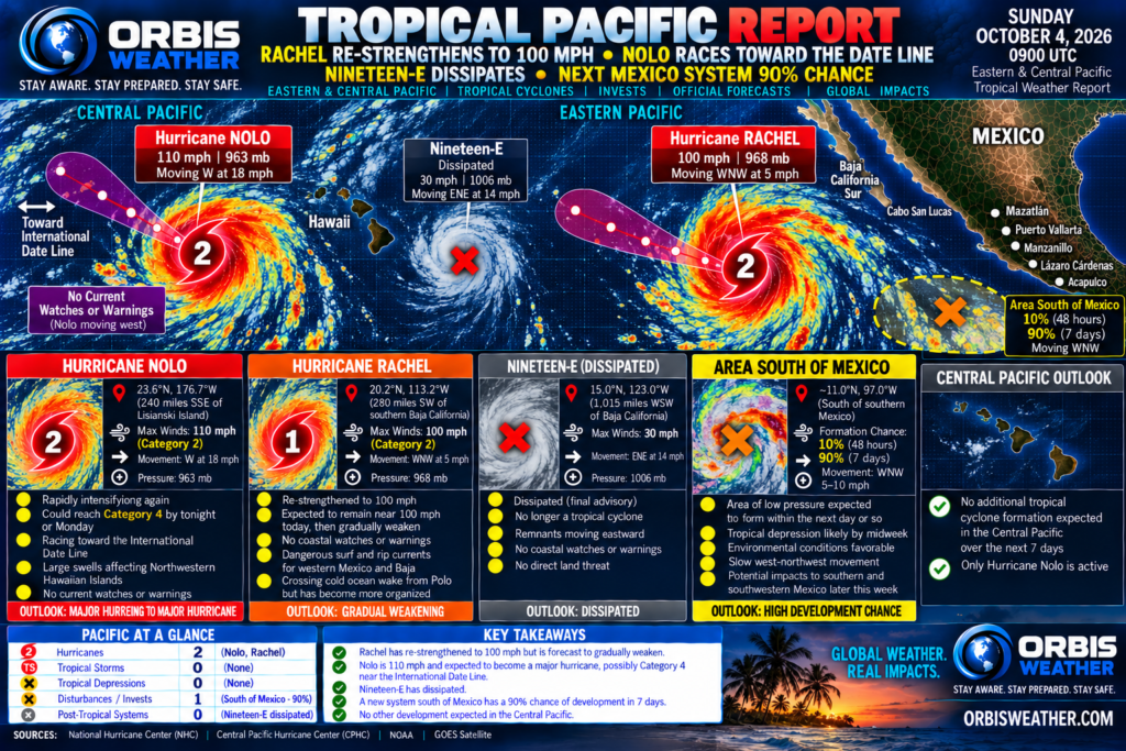
The Tropical Pacific remains highly active Sunday morning, with two hurricanes still spinning across the Eastern and Central Pacific and another tropical cyclone increasingly likely to form near Mexico later this week.
The biggest overnight surprise is Hurricane Rachel, which has strengthened again to 100 mph southwest of Baja California despite earlier expectations that the storm would begin a steady decline. Farther west, Hurricane Nolo remains a powerful 110-mph Category 2 hurricane and is racing toward the International Date Line, which it is expected to cross later today. Meanwhile, the National Hurricane Center has increased the seven-day formation probability for the next potential system south of Mexico to 90%, with a tropical depression now expected during the middle to latter part of the week. National Hurricane Center
🔴 Hurricane Rachel — Strengthens Again Southwest of Baja
Rachel has staged another unexpected increase in intensity.
As of the 2:00 AM MST / 0900 UTC Sunday advisory, Rachel was centered near:
📍 20.2°N, 113.2°W
📍 About 280 miles / 455 km southwest of the southern tip of Baja California
💨 Maximum sustained winds: 100 mph / 155 km/h
🔽 Minimum pressure: 968 mb
↖️ Movement: west-northwest at 5 mph / 7 km/h
Rachel is a Category 2 hurricane. National Hurricane Center
Satellite imagery shows that Rachel became noticeably better organized overnight. Although the eye remains somewhat indistinct, the eyewall thunderstorms have become more symmetrical, with extremely cold cloud tops surrounding the center. National Hurricane Center
🌀 Rachel Defies Polo’s Cold Wake
One of the more interesting aspects of Rachel’s resurgence is where it is occurring.
NHC sea-surface-temperature analysis indicates Rachel should currently be crossing the cold ocean wake left behind by former Hurricane Polo.
Normally, that cooler water would work against strengthening.
Instead, Rachel has become better organized.
NHC specifically notes that the hurricane’s current development trend is not consistent with what would normally be expected while crossing Polo’s cold wake. National Hurricane Center
Rachel should move over slightly warmer water during the next 24 hours, theoretically allowing some additional strengthening.
However, official intensity guidance does not currently show further strengthening.
Because of those conflicting signals, NHC holds Rachel near 100 mph through today, followed by gradual weakening. National Hurricane Center
📉 Official Rachel Intensity Forecast
The latest official forecast calls for approximately:
Sunday: 100 mph — Category 2
Early Monday: 90 mph — Category 1
Monday afternoon: 90 mph
Tuesday: 85–80 mph
Early Wednesday: around 75 mph
Thursday: around 65 mph — Tropical Storm
Friday: around 50 mph — Tropical Storm. National Hurricane Center
Rachel therefore remains a hurricane considerably longer than earlier forecasts suggested, although a gradual weakening trend is still expected.
⬅️ Turn Toward the West Expected
Rachel is moving west-northwestward very slowly.
A strengthening mid-level ridge north of the hurricane should gradually turn Rachel toward the west while increasing its forward speed during the next three days.
Later in the forecast period, a mid-latitude trough approaching from the west should weaken that ridge, causing Rachel to bend back toward the west-northwest. National Hurricane Center
Importantly, the track guidance is currently fairly tightly clustered, giving forecasters relatively good confidence in the broad westward movement.
There are no coastal tropical cyclone watches or warnings in effect for Rachel.
🌊 Baja California — Dangerous Seas Continue
Although Rachel’s center is moving away from Mexico, its marine footprint remains significant.
NHC marine forecasts indicate seas around Rachel have been reaching approximately 36 feet / 11 meters near the hurricane. National Hurricane Center
Rachel-generated swells will continue spreading across offshore waters of Baja California, particularly south of Punta Eugenia, through at least Monday night.
Rough seas will also persist near the entrance to the Gulf of California through Sunday night. National Hurricane Center
The primary hazard for Mexico is therefore dangerous surf, rip currents and hazardous marine conditions rather than direct hurricane-force winds.
🔴 ORBIS STATUS: CATEGORY 2 — 100 MPH / SLOW WEAKENING FORECAST
🔴 Hurricane Nolo — 110 MPH and Racing Toward the International Date Line
Nolo remains an exceptionally powerful hurricane, although it has backed away slightly from major-hurricane strength.
At 11:00 PM HST Saturday / 0900 UTC Sunday, Nolo was centered near:
📍 23.6°N, 176.7°W
📍 About 240 miles / 390 km southwest of Lisianski Island
📍 About 405 miles / 655 km west-southwest of Maro Reef
💨 Maximum sustained winds: 110 mph / 175 km/h
🔽 Minimum pressure: 963 mb
⬅️ Movement: west at 18 mph / 30 km/h. National Hurricane Center
Hurricane-force winds extend outward approximately 35 miles / 55 km, while tropical-storm-force winds extend as far as 150 miles / 240 km from Nolo’s center. National Hurricane Center
There are now no tropical cyclone watches or warnings in effect for Nolo.
🌏 Nolo Crosses the International Date Line Today
Nolo is moving quickly westward.
The official forecast calls for the hurricane to continue generally westward during the next several days and cross the International Date Line by midday Sunday Hawaiian time. National Hurricane Center
That will mark an important transition.
Once Nolo moves west of 180° longitude, it will leave the Central Pacific and enter the Western Pacific basin.
Forecast responsibility will then transition away from the Central Pacific system.
🚀 Another Strengthening Phase Possible
Nolo’s extraordinary intensity fluctuations may not be finished.
The official forecast calls for Nolo to begin strengthening again during the next day or two, followed by abrupt weakening around the middle of the week. National Hurricane Center
That means another period of major-hurricane intensity remains possible as Nolo approaches and crosses the Date Line.
The exact peak intensity is less certain than the track.
🌊 Northwestern Hawaiian Islands — Large Swell Continues
Although Nolo is rapidly leaving Hawaii behind, its enormous ocean swell remains a hazard.
Large swell associated with the hurricane will continue affecting the Papahānaumokuākea Marine National Monumentduring the next several days.
Official forecasters warn that surf could inundate some low-lying atolls between Maro Reef and Lisianski Island. National Hurricane Center
The main Hawaiian Islands are not under tropical cyclone watches or warnings.
🔴 ORBIS STATUS: 110-MPH HURRICANE — CROSSING DATE LINE TODAY
🟡 South of Southern Mexico — Development Chance Surges to 90%
This is today’s most important development outside the two active hurricanes.
NHC now expects a broad area of low pressure to develop within the next day or so just south of the Gulf of Tehuantepec.
Environmental conditions are expected to become increasingly favorable for tropical development after the low forms.
Latest Official Formation Probabilities
⏱️ Next 48 hours: 10% — LOW
📅 Next 7 days: 90% — HIGH. National Hurricane Center
That seven-day probability has increased from:
70% Thursday
➡️ 80% Friday and Saturday
➡️ 90% today.
NHC now explicitly says a tropical depression is expected to form during the middle to latter portion of this week. National Hurricane Center
🇲🇽 Track Could Keep System Near Mexico
This disturbance deserves particularly close attention because of where it is expected to travel.
The developing system should move slowly:
↖️ West-northwestward to northwestward
while remaining just offshore of southern and southwestern Mexico. National Hurricane Center
That trajectory could eventually place coastal areas from Oaxaca and Guerrero toward Michoacán and Colima within the broader zone to monitor.
However, it is far too early to determine specific impacts.
Is It an Invest?
The latest official NHC outlook does not identify the disturbance as a designated invest.
A defined tropical cyclone does not yet exist.
Therefore, there is currently:
No official center position
No official forecast cone
No official intensity forecast
No coastal tropical cyclone watches or warnings.
NHC marine forecasts indicate winds and seas could begin increasing around the Gulf of Tehuantepec region late this weekend or early next week as the low begins forming. National Hurricane Center
🟡 ORBIS STATUS: HIGH DEVELOPMENT RISK — 10% / 90%
🟢 Rest of the Central Pacific — No New Development Expected
Outside Nolo, the Central Pacific remains quiet.
The latest Central Pacific Hurricane Center Tropical Weather Outlook states that tropical cyclone formation is not expected elsewhere across the Central Pacific during the next seven days. National Hurricane Center
There are therefore no additional CPHC-designated disturbances or invests currently requiring monitoring.
📊 PACIFIC AT A GLANCE — OCTOBER 4
| System | Official Status | Latest Official Data | Primary Concern |
|---|
| 🔴 Rachel | Category 2 Hurricane | 100 mph / 968 mb | Baja surf; gradual weakening |
| 🔴 Nolo | Category 2 Hurricane | 110 mph / 963 mb | Date Line crossing; huge swell |
| 🟡 South of Mexico | Development Area | 10% / 90% | Depression expected this week |
| 🟢 Rest of Central Pacific | Quiet | No formation expected | None |
🖥️ Official Forecast vs. Model Guidance
🔴 Rachel
The official NHC forecast keeps Rachel near 100 mph today, followed by gradual weakening beginning tonight into Monday. National Hurricane Center
There are mixed environmental signals.
Rachel is crossing Polo’s cold wake, which normally favors weakening, but it has nevertheless become better organized. Slightly warmer water lies ahead, while intensity guidance generally favors weakening rather than additional strengthening.
NHC therefore holds the hurricane steady initially before beginning a slow decline.
A model showing Rachel suddenly becoming a major hurricane again should not be interpreted as the official forecast.
🔴 Nolo
The official forecast calls for Nolo to cross the International Date Line today while maintaining a generally westward track.
Additional strengthening is forecast during the next day or two, followed by much faster weakening around midweek. National Hurricane Center
The precise peak intensity remains uncertain.
The westward track toward the Date Line is considerably more certain than exactly how strong Nolo becomes.
🟡 Southern Mexico Development Area
No tropical cyclone currently exists.
The official forecast is a 10% probability of formation through 48 hours and 90% through seven days, with NHC expecting a tropical depression during the middle to latter part of the week. National Hurricane Center
Any model showing a specific storm name, hurricane category, exact coastal approach or landfall is therefore guidance only — not an official NHC forecast.
👀 ORBIS AREAS TO WATCH TODAY
🇲🇽 Southern and southwestern Mexico — Priority No. 1 for future development. The formation probability has reached 90%, and the prospective cyclone could track slowly just offshore later this week. Residents from Oaxaca westward along Mexico’s Pacific coast should monitor future outlooks.
🏜️ Baja California Peninsula — Rachel remains offshore. No direct landfall is forecast, but large swells and dangerous marine conditions continue.
🌏 International Date Line — Nolo arrives today. The hurricane should cross from the Central Pacific into the Western Pacific by midday Hawaiian time.
🏝️ Northwestern Hawaiian Islands — lingering Nolo swell. Large surf could still inundate vulnerable low-lying atolls even as the hurricane races westward. National Hurricane Center
🌀 ORBIS BOTTOM LINE
Sunday begins with two Category 2 hurricanes and a third potential tropical cyclone increasingly likely to form.
Rachel has unexpectedly strengthened back to 100 mph southwest of Baja California. Its improving satellite appearance surprised forecasters because the hurricane is crossing the cooler ocean wake left by Polo. The official forecast nevertheless calls for Rachel to hold near its present strength today before gradually weakening beginning Monday. National Hurricane Center
Nolo remains a powerful 110-mph hurricane and is racing west at 18 mph. It should cross the International Date Line later today, ending its time in the Central Pacific. Additional strengthening remains possible before a much faster weakening trend develops around midweek. National Hurricane Center
And attention is rapidly returning to Mexico.
The next development zone south of the Gulf of Tehuantepec has climbed to a 90% seven-day formation probability. NHC now expects a tropical depression to form during the middle to latter part of the week while moving slowly just offshore of southern and southwestern Mexico. National Hurricane Center
Today’s Pacific headline: Rachel has unexpectedly strengthened back to 100 mph, Nolo is racing toward the International Date Line at 110 mph — and the next potential cyclone near Mexico now has a 90% chance of formation.
National Hurricane Center & Central Pacific Hurricane Center • Latest Hurricane Rachel Information • Rachel Forecast Discussion • Latest Hurricane Nolo Advisory • Eastern & Central Pacific Tropical Weather Outlook
Stay Aware. Stay Prepared. Stay Safe.
ORBIS WEATHER — Global Weather. Real Impacts.