Super Typhoon Dolphin Weakens Slightly but Remains a Major Threat as It Churns Toward Japan
By Orbis Weather Staff | August 2, 2026
A typhoon that exploded from a tropical depression into one of the strongest storms of the year is now on a slow northwest track through the open western Pacific, keeping meteorologists across the region on alert even as it shows early signs of weakening.
Explosive Intensification
Typhoon Dolphin first organized as a tropical depression on July 27 and underwent what forecasters describe as textbook rapid intensification, with sustained winds jumping from 35 mph to 140 mph in roughly 48 hours. The storm peaked at Category 5-equivalent strength around July 30, with maximum sustained winds estimated near 165 to 167 mph — a benchmark that places Dolphin among the most powerful tropical cyclones observed anywhere in the world so far this year.
Current Status
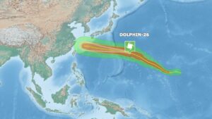
As of the most recent confirmed position report, taken August 1 at 3 p.m. UTC, Dolphin was centered approximately 970 miles east of Iwo To in the western Pacific, still packing sustained winds near 137 mph (220 km/h) with gusts to 174 mph (280 km/h) and a central pressure of 937 millibars. The system was moving northwest at roughly 17 mph.
Forecasters say the modest weakening trend is expected to continue as increasing wind shear and declining ocean heat content erode the storm’s structure, aided by at least one eyewall replacement cycle already underway. Despite that trend, Dolphin is expected to remain a powerful and dangerous typhoon for at least the next several days.
Track Uncertain Beyond Five Days
Dolphin’s forecast track has held with relatively high confidence over the next 72 hours, continuing generally northwest before a subtropical ridge building near the Korean Peninsula begins to exert more influence on its path. Some forecast guidance suggests the storm could bring Okinawa and southwestern Japan into range by the middle to latter part of this week, though meteorologists caution that the eventual bend in its track — whether toward mainland Japan, a recurve toward the Korean Peninsula, or a more westward push toward China — remains genuinely uncertain at this range.
As of the latest reporting, U.S. military installations in the region, including Kadena Air Base in Okinawa, remained at standard seasonal tropical cyclone readiness, with no elevated alert level yet issued.
Orbis Weather notes that a small number of secondary outlets have circulated reports suggesting a track toward the Philippines and Taiwan. That scenario is inconsistent with Dolphin’s confirmed position well east of Japan’s Bonin Islands, and readers should treat it with skepticism pending confirmation from primary agencies. For the most current and authoritative track information, Orbis Weather recommends consulting the Joint Typhoon Warning Center (JTWC) and the Japan Meteorological Agency (JMA) directly, as forecasts at this range can still shift meaningfully.
Orbis Weather will continue to monitor Typhoon Dolphin and provide updates as new advisories are issued.
Orbis Weather Staff report, compiled from National Hurricane Center analogues, Joint Typhoon Warning Center data, and reporting from Weather Underground, AccuWeather, Zoom Earth, and Yale Climate Connections.