Flooding Leaves Massachusetts Roads Impassable as Severe Storms Move Through
By Orbis Weather Staff | August 3, 2026
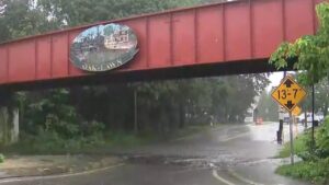
The slow-moving storm system that triggered flash flood warnings across New Hampshire and Massachusetts earlier today has made good on the threat, leaving roads impassable across central and western Massachusetts by mid-afternoon. As of a 3:17 p.m. update, water and downed trees had closed streets in at least six communities, and forecasters said several more inches of rain were still expected before the system finally clears the region.
The Fitchburg-Lowell-Leominster corridor has taken the worst of it. In Lunenburg, Electric Avenue — Route 13 — is closed between West Street and Whalom Road. Next door in Leominster and Fitchburg, Merriam Avenue is shut at the Route 2 interchange, and Route 2 itself has been reduced to a single lane in each direction. Meteorologists had flagged this corridor over the weekend as one of the areas most likely to flood, in part because it had already absorbed several inches of rain from an earlier storm just days prior, leaving the ground with little capacity to soak up more.
Farther west, Piper Cross Road in West Springfield is completely underwater, and South Hadley has multiple flooded streets across town. Flooding has also been reported in Brockton, southeast of Boston, while in Westminster a downed tree — a product of the storm’s damaging wind gusts — has closed Spruce Road near 38 Spruce Road. Forecasters had separately warned of isolated severe thunderstorms capable of producing damaging winds across interior areas, with gusts of 40 to 50 mph expected as the system pushed toward Cape Cod and the Islands.
Flash flood warnings remain in effect for western and central Massachusetts, as well as for the Hartford and Springfield areas, as rain continues to fall on already-saturated ground. No water rescues or injuries have been reported in connection with today’s flooding, and the closures so far appear to be limited to roads rather than any evacuations. Still, the National Weather Service is repeating its standard warning for a reason: most flood deaths happen in vehicles. A car can stall in as little as 6 inches of moving water, begin to float in 12 inches, and be swept away entirely in 18 to 24 inches — which is why officials are urging drivers to turn around rather than attempt to cross a flooded roadway, however familiar the route.
Forecasters expect the rain to taper off through the evening as the system finally pushes offshore, with drier and less humid conditions returning behind it overnight and into Tuesday.
Orbis Weather will continue to monitor road conditions and flood warnings across Massachusetts as this system exits the region. This report was compiled from the National Weather Service, Boston 25 News, Boston.com, and the Boston Globe.
Sources