Grasshopper Fire Nears 40,000 Acres, Threatens Mt. Hood Meadows and Sends Smoke Into Portland
By Orbis Weather Staff | August 6, 2026
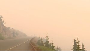
A lightning-sparked wildfire burning across Oregon’s Mount Hood region has grown to nearly 40,000 acres, prompting mandatory evacuations at a major ski resort, evacuation notices at the historic Timberline Lodge, and hazardous smoke that has pushed Portland’s air quality among the worst of any major U.S. city this week. The Grasshopper Fire, burning south of Mount Hood across Wasco, Hood River, and Clackamas counties, is now one of the largest and most closely watched fires in a season that has already pushed Oregon toward a record for acreage burned.
Fire Growth and Location
The Grasshopper Fire ignited in late July from a lightning strike in the Badger Creek Wilderness in southern Wasco County. It has grown steadily since, reaching 31,571 acres and 17% containment by August 3 before crossing into Clackamas County and continuing to expand. As of the Oregon State Fire Marshal’s August 5 update, the fire had burned 39,439 acres with containment at 20%. Crews have made progress reinforcing lines along Forest Roads 45 and 50 and successfully secured a slopover — an area where the fire had jumped containment lines — in the northeast. The fire has now reached Bennett Pass and continues to burn around Lookout Mountain, advancing toward Highway 35, which remains open to traffic for now.
Evacuations at Mt. Hood Meadows and Timberline Lodge
The fire’s push toward the mountain’s ski areas has triggered a cascade of evacuation orders. Mt. Hood Meadows ski resort is under a Level 3 “Go Now” mandatory evacuation, and the resort has been evacuated while fire crews actively defend the property, aided by significant defensible space around the facility. Nearby, the historic Timberline Lodge — familiar to many as the exterior filming location for “The Shining” — remains open under a Level 1 “Be Ready” notice, though its mountain operations have closed and management has said it will shut down entirely if evacuation levels escalate. Deteriorating air quality readings of 130 to 180 have already pushed many guests to leave early. In Clackamas County, the communities of Rhododendron, Government Camp, and the surrounding area — about 200 properties — remain under Level 1 “Be Ready” warnings, with county officials activating their sheriff’s office and disaster management operations as the fire moved into the county. Government Camp residents face particular difficulty evacuating given limited transportation options in and out of the area. Meanwhile, Level 3 “Go Now” orders remain active in parts of Hood River and Wasco counties, and a large section of the Mt. Hood National Forest has been closed, with temporary flight restrictions in place over the fire area.
Firefighting Response
More than 1,320 personnel are now assigned to the Grasshopper Fire, working hand crews and bulldozers to build and reinforce suppression lines under difficult, steep terrain that in many areas limits the use of heavy equipment. Battalion Chief Greg Barnum described crews having to “literally do it by hand and foot, walk-in, dig it out by hand” in the roughest sections. Oregon State Fire Marshal structural triage teams have completed protective preparation work around the Mt. Hood Meadows Resort and are continuing similar efforts on the fire’s western side.
Smoke Blankets Portland
Smoke from the Grasshopper Fire has become the dominant air-quality story for the Portland metro area this week. On Wednesday, Portland ranked third among major U.S. cities for poor air quality, with conditions rated unhealthy for sensitive groups amid a regional total of more than 2 million acres burned across roughly 1,200 wildfires in the Pacific Northwest. Hazardous air quality is expected to persist between Rhododendron and Parkdale. Emergency departments have reported an uptick in visits tied to smoke and heat exposure, with an unexpectedly high share of those visits coming from adults ages 18 to 44 — a pattern health officials say suggests younger adults may be underestimating the risks of prolonged smoke exposure. Forecasters expect a shift to west winds by Thursday to help clear smoke from the Portland metro area, though the fire itself is expected to keep burning well beyond that.
A Record-Setting Season
The Grasshopper Fire is unfolding against the backdrop of an already historic wildfire season in Oregon, which has burned more than 2 million acres so far this year and is on pace to surpass its 2024 record for total acreage burned in a single season. To the south, the Little Buck Fire — a separate blaze — has burned 43,818 acres and reached 89% containment, with all evacuation notices for that fire now lifted, offering a preview of the kind of long-duration battle crews expect with the still-growing Grasshopper Fire.
Orbis Weather will continue tracking the Grasshopper Fire’s growth, containment, and evacuation status as conditions evolve. Residents near Mount Hood should follow guidance from the Oregon State Fire Marshal and their county sheriff’s office for the latest updates.
Compiled from the Oregon State Fire Marshal, OPB, Willamette Week, KATU, and Columbia Community Connection News.
Sources