Flash Flood Warnings Sweep Massachusetts and New Hampshire as Slow-Moving Storm Drenches New England
By Orbis Weather Staff | August 3, 2026
A slow-moving band of heavy rain and thunderstorms parked itself over New England today, triggering a rolling series of flash flood warnings across New Hampshire and Massachusetts as downpours dropped more than two inches of rain in a matter of hours over already-saturated ground. The system, which forecasters had flagged over the weekend as the wettest weather of the work week, arrived largely as advertised: repeated rounds of training thunderstorms rather than one clean-moving line, the kind of setup meteorologists watch closely because it tends to dump the heaviest rain on the same neighborhoods over and over.
New Hampshire bore the brunt of it first. The National Weather Service issued a flash flood warning for southeastern Merrimack County, southwestern Strafford County, southern Hillsborough County, and Rockingham County that ran until 11:15 a.m., after those areas had already picked up between 1 and 2.5 inches of rain with more falling. Forecasters warned that rainfall rates could climb as high as 1 to 3 inches per hour on top of that, a pace capable of overwhelming culverts, small streams, and poor-drainage areas in a hurry.
Massachusetts saw a similar pattern play out through the morning and into the evening commute. NWS Boston/Norton issued its first warning of the day at 6:49 a.m. for northern Worcester County and northwestern Middlesex County, where Doppler radar showed 1 to 2 inches of rain had already fallen with thunderstorms continuing to pump in more; a follow-up warning at 8:01 a.m. extended the threat as rainfall rates of 1 to 2 inches per hour continued. By afternoon, the warning zone had shifted west and south to cover Worcester, southern Franklin, central Hampden, and southwestern Hampshire counties — a stretch of the Pioneer Valley that included Northampton, Amherst, Greenfield, Deerfield, Chicopee, Ludlow, South Hadley, Belchertown, Palmer, Ware, and more than a dozen other communities — with warnings running until 8 p.m. in most spots and 6 p.m. around Springfield.
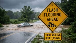
The Weather Service’s core concern throughout the day was the same one it raises with nearly every flash flood event: water over roads. Forecasters specifically warned of flooding on small creeks and streams, in urban areas, and across highways, streets, underpasses, and other low-lying or poorly drained spots, and they urged drivers not to attempt to cross flooded roadways, noting that most flood deaths occur in vehicles. As of the latest information available, eastern Massachusetts — including Boston proper — had not been placed under a flood watch, though forecasters said heavy rain was expected to linger into the evening commute, and no injuries, water rescues, or road-washout reports had been confirmed in the affected counties.
Meteorologists expect the rain to taper off as the system pulls offshore overnight, with drier, less humid air returning behind it. Tuesday’s forecast calls for the moisture to clear out and humidity to drop significantly, with the rest of the week trending partly cloudy and warm, in the mid-to-upper 80s.
Orbis Weather will continue to monitor conditions across New England as this system exits the region. This report was compiled from the National Weather Service offices in Boston/Norton, Massachusetts and Gray, Maine, and from reporting by the Boston Globe, Boston 25 News, Yahoo News, The Pulse of NH, and the Miranda Warning System.
Sources