Tropical Depression Luis Makes Landfall in Isabela, PAGASA Says, as Flood Threat Persists Across Northern Luzon
ORBIS WEATHER — August 3, 2026
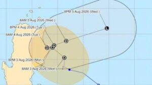
Tropical Depression Luis came ashore in Isabela province on Monday evening, the Philippine weather bureau confirmed, ending a day of erratic, near-stationary drifting off the coast of Northern Luzon and setting up what forecasters expect to be a swift exit back out to sea — even as flooding rain continues to threaten a wide swath of the region.
PAGASA said Luis made landfall over Maconacon, Isabela, at around 5:30 p.m. local time, with the depression’s center carrying maximum sustained winds of 45 km/h and gusts of up to 60 km/h as it moved northwestward at 20 km/h. The landfall capped a sluggish approach: earlier Monday, PAGASA had clocked the system barely moving roughly 130 kilometers east-southeast of Casiguran, Aurora, prompting forecasters to repeatedly caution that Luis’s track remained “highly uncertain” in the run-up to landfall.
With the center now over land, PAGASA said Luis is expected to sharply turn east-northeastward, pulling back out over the Pacific and away from the Philippine landmass in the coming hours. The agency reiterated its expectation that the system will not strengthen much further, likely remaining a tropical depression for most of its remaining life before weakening into a remnant low by Wednesday, August 5. At that point, PAGASA said, what is left of Luis is forecast to be fully absorbed into the far larger circulation of Typhoon Dolphin, which is churning across the open Western Pacific well outside Philippine waters.
Ten areas of Luzon remained under Tropical Cyclone Wind Signal No. 1 as the depression came ashore: the central and eastern portions of Cagayan, including the Babuyan Islands; Isabela; Quirino; the eastern and southern portions of Apayao; eastern Kalinga; eastern Mountain Province; eastern Ifugao; northern Aurora; the Polillo Islands; and northern Camarines Norte. PAGASA has consistently characterized the wind threat itself as “minimal to minor” for life and property in those areas — Luis never approached tropical-storm strength before landfall — but has been far more emphatic about the rain.
Rainfall, not wind, remains the storm’s primary hazard. In bulletins issued through Monday, PAGASA kept a red rainfall warning in place for Pangasinan, where accumulations were forecast to exceed 200 millimeters, raising the risk of what the agency called “widespread severe flooding and landslides.” An orange warning covering La Union, Tarlac, Zambales and Bataan called for 100 to 200 millimeters, while a broader yellow warning spanning 14 additional areas — including Metro Manila, Aurora and Bulacan — anticipated 50 to 100 millimeters. Forecasters also flagged that an enhanced southwest monsoon, interacting with Luis’s circulation, would continue driving strong to gale-force gusts across most of Luzon and the Visayas into Tuesday, and warned that heavy rain and severe winds could still be felt in localities well outside the storm’s forecast track and landfall point.
Luis’s brief and relatively weak passage over Northern Luzon stands in sharp contrast to the system it is ultimately forecast to be absorbed by. Typhoon Dolphin peaked at Category 5-equivalent strength in late July — with the Joint Typhoon Warning Center clocking sustained winds near 270 km/h and a central pressure of 910 millibars — making it, according to Yale Climate Connections, the strongest typhoon on record to develop so close to the International Date Line. Dolphin has since weakened considerably as it tracks toward Japan’s Ogasawara and Daito island chains, but it remains a far more powerful system than Luis ever became, underscoring how differently two cyclones active in the same basin on the same day can behave.
Looking ahead, PAGASA’s forecast points to a fast-fading threat from Luis itself, with the depression expected to lose its identity within Dolphin’s circulation by midweek. But residents across Northern Luzon — particularly in Pangasinan and the other provinces under rainfall warnings — face the more immediate risk of flooding and landslides through Tuesday as the system’s rain bands and the reinforced southwest monsoon continue to move through. Orbis Weather urges residents in affected areas to monitor official PAGASA bulletins, avoid travel through flood-prone and landslide-prone terrain, secure loose outdoor objects, and follow any evacuation guidance issued by local disaster-risk reduction offices.
Sources
This article was compiled by Orbis Weather from publicly available reporting for illustrative branding purposes. It is not an official product of the Joint Typhoon Warning Center, the Japan Meteorological Agency, PAGASA, NOAA, or any other government meteorological agency. For official warnings, advisories and evacuation orders, consult those agencies directly.