🌊 Tropical Cyclone DOLPHIN-26 Update
Orbis Weather | Thursday, July 30, 2026
🟢 Humanitarian Impact Assessment: LOW
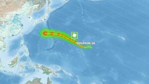
Tropical Cyclone DOLPHIN-26 remains a powerful typhoon over the western Pacific, but it is currently expected to have a LOW humanitarian impact because it is tracking over open waters with very limited population exposure. The Global Disaster Alert and Coordination System (GDACS) has issued an Overall Green Alert, indicating a low risk based on the storm’s maximum sustained wind speed, exposed population, and regional vulnerability. (GDACS)
🌀 Current Storm Overview
Storm Name: Tropical Cyclone DOLPHIN-26
Basin: Western Pacific Ocean
Status: Powerful Typhoon
Movement: Northwest over open waters
Primary Hazards: Destructive winds near the eyewall, dangerous seas, and very large swells
Although DOLPHIN-26 has intensified into a powerful typhoon, it is forecast to remain away from major population centers in the near term, greatly reducing the potential for significant humanitarian impacts. (Facebook)
📊 Humanitarian Impact Analysis
🌬️ Maximum Sustained Wind Speed
Rating: 🔴 Extreme Storm Intensity
DOLPHIN-26 has strengthened into a major typhoon capable of producing destructive winds near its core.
Storm Characteristics:
-
🌪️ Major typhoon over the western Pacific
-
🌊 Extremely rough seas and dangerous marine conditions
-
⚠️ Severe conditions remain largely confined to open ocean
While winds near the center are extremely dangerous, the absence of a direct impact on populated land areas significantly lowers the humanitarian risk. (GDACS)
👥 Population Exposure
Rating: 🟢 Very Low
The strongest winds remain well offshore.
Exposure Assessment:
-
✅ No significant population currently exposed to the core of the storm
-
✅ No widespread evacuations reported
-
✅ No major urban areas under immediate threat
-
✅ Marine interests remain the primary concern
GDACS continues to classify DOLPHIN-26 as a Green Alert event due to its limited exposure to vulnerable populations. (GDACS)
🏘️ Vulnerability Assessment
Rating: 🟢 Low
Current factors limiting humanitarian impacts include:
-
✅ Offshore track
-
✅ Minimal infrastructure exposure
-
✅ Limited risk of storm surge affecting populated coastlines
-
✅ No reports of widespread damage or casualties
The greatest hazards remain for shipping interests and anyone venturing into the western Pacific near the cyclone’s path. (GDACS)
🌍 Orbis Weather Impact Scale
| Category |
Assessment |
| 🌪️ Wind Strength |
🔴 Extreme |
| 🌊 Marine Conditions |
🔴 Very Dangerous |
| 🏝️ Land Impact |
🟢 Minimal |
| 👥 Population Exposure |
🟢 Very Low |
| 🏥 Vulnerability |
🟢 Low |
| 🌎 Humanitarian Impact |
🟢 LOW |
🛰️ Forecast Outlook
DOLPHIN-26 is expected to remain over the open western Pacific while maintaining dangerous conditions for marine interests. Forecast guidance indicates that, despite its impressive intensity, the typhoon should continue to pose little direct threat to populated land areas in the short term. Forecasters will continue to monitor for any future changes in track or intensity. (Weaver’s Weather & Typhoon Center)
🌎 Orbis Weather Summary
Tropical Cyclone DOLPHIN-26 is a powerful western Pacific typhoon, but its current track over open waters keeps the humanitarian threat low. Despite extreme winds capable of causing severe damage, limited population exposure and low regional vulnerability support a LOW humanitarian impact assessment.
🟢 Overall Humanitarian Impact: LOW
🌊 Primary Threat: Dangerous Seas & Large Swells
🏝️ Land Threat: Minimal at This Time (GDACS)