
Winter Weather Lower 48




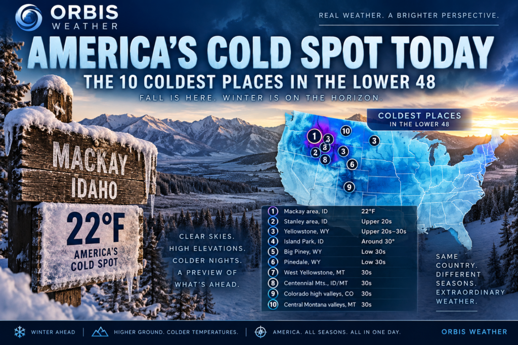

❄️ America’s Cold Spot Today: The 10 Coldest Places in the Lower 48
Thursday, September 17, 2026 | Orbis Weather
September may still feel like summer across much of the United States, but temperatures in the mountains and high valleys of the West are already giving an early taste of the cold season.
The coldest air is concentrated across the higher elevations and sheltered valleys of Idaho, Wyoming, Montana and the central Rockies, where clear skies, dry air and elevation allow temperatures to fall rapidly overnight.
According to preliminary NOAA Weather Prediction Center observations, the official Lower 48 cold spot for Wednesday, September 16 was 14 miles west-southwest of Mackay, Idaho, where the temperature fell to just 22°F (-5.6°C).
That is remarkably cold for mid-September — and cold enough for a hard freeze.
🥶 The 10 Coldest Places in the Lower 48 Today
Because observations continue to arrive and remote mountain stations can report later than major airports, the exact order can change through the morning. Based on the latest available observations and temperature patterns, these are the areas sitting among America’s coldest spots as Thursday begins:
| Rank | Location | State | Approx. Coldest Temperature |
|---|---|---|---|
| 🥇 1 | Mackay-area high country | Idaho | 22°F / -5.6°C |
| 🥈 2 | Stanley / Sawtooth high country | Idaho | Upper 20s°F / around -3°C |
| 🥉 3 | Yellowstone high country | Wyoming | Upper 20s–30s°F / around -2 to 0°C |
| 4 | Island Park region | Idaho | Around 30°F / -1°C |
| 5 | Big Piney high country | Wyoming | Low 30s°F / around 0°C |
| 6 | Pinedale-area valleys | Wyoming | Low 30s°F / around 0°C |
| 7 | West Yellowstone region | Montana | 30s°F / 0–4°C |
| 8 | Centennial Mountains | Idaho/Montana | 30s°F / 0–4°C |
| 9 | Colorado high mountain valleys | Colorado | 30s°F / 0–4°C |
| 10 | Central Montana mountain valleys | Montana | 30s°F / 0–4°C |
Important: Only the 22°F Mackay-area reading is being presented here as a confirmed NOAA/WPC national extreme. The remaining entries identify the coldest regions and approximate temperature ranges rather than claiming an official station-by-station national ranking. NOAA notes that its national high/low observations are preliminary and can be revised when late reports arrive.
🏆 America’s Cold Spot: Central Idaho
For now, the cold crown belongs to central Idaho.
The Weather Prediction Center reported a temperature of 22°F (-5.6°C) about 14 miles west-southwest of Mackay on Wednesday. That was the lowest temperature received by WPC from the contiguous United States by its evening reporting cutoff.
At 22°F, exposed vegetation can experience a damaging freeze, and water left outside can begin freezing. It is a striking reminder of how dramatically conditions can differ between America’s mountain valleys and the warmer lowlands during September.
🏔️ Why Idaho Gets So Cold
Central Idaho contains an almost perfect recipe for extreme nighttime cooling.
Elevation is the first ingredient. Many valleys are thousands of feet above sea level and are surrounded by considerably higher mountains.
Dry air also allows heat accumulated during the daytime to escape rapidly after sunset. When skies are clear and winds become light, the ground radiates heat into the atmosphere and temperatures can plunge.
Then there is cold-air drainage.
Cold, dense air naturally sinks down mountain slopes and collects in valleys and basins. These locations can become significantly colder than nearby hillsides — sometimes producing surprisingly low temperatures even when the larger weather pattern isn’t especially cold.
That combination makes Idaho’s mountain valleys frequent contenders for America’s coldest temperature outside Alaska.
🌡️ A Huge Temperature Divide Across America
While frost and freezing temperatures are appearing in parts of the mountainous West, summer remains firmly in control elsewhere.
The contrast on Wednesday was extraordinary.
NOAA’s Weather Prediction Center reported a national high of 106°F (41.1°C) at Stovepipe Wells, California, and near La Puerta, Texas, while the Mackay-area station in Idaho dropped to 22°F (-5.6°C).
That’s an 84°F temperature difference across the Lower 48 in roughly the same calendar day.
Meanwhile, the Weather Prediction Center says record-challenging heat continues across parts of the south-central United States while heavy rainfall and flash-flood concerns affect portions of the Southwest, Northern Plains and Upper Midwest.
In other words, America is experiencing several seasons at once.
❄️ Is Winter Arriving Early?
Not quite.
A 22°F reading certainly looks like winter on a thermometer, but isolated freezes in high-elevation western valleys can occur well before widespread winter weather develops across the country.
The more important signal during September is the expanding frequency of freezing nights.
As daylight continues to shorten and nighttime cooling becomes more efficient, the freezing line will gradually spread from the highest mountains and northern valleys toward lower elevations.
Over the coming weeks, frost and freeze events should become increasingly common across the Rockies, northern Plains, Upper Midwest and eventually much of the northern United States.
🌨️ The Race Toward Winter Has Begun
September is one of the most dramatic transition months on the American weather calendar.
Desert locations can still exceed 100°F while frost forms hundreds of miles away. Mountain valleys can fall below freezing overnight and then rebound dramatically under afternoon sunshine.
That enormous temperature range is exactly what we’re seeing now.
For September 17, the early-season cold spotlight remains firmly on the mountainous West — with central Idaho emerging as America’s standout cold zone and a preliminary 22°F reading near Mackay setting the benchmark.
📍 Orbis Weather Cold Spot
❄️ Coldest confirmed Lower 48 temperature: 22°F (-5.6°C)
📍 Location: 14 miles WSW of Mackay, Idaho
🏔️ Region: Central Idaho high country
🔥 Lower 48 high: 106°F (41.1°C)
🌡️ National temperature spread: 84°F / 46.7°C
📅 Date: September 16–17, 2026
Orbis Weather tracks America’s coldest locations as the country transitions from summer into fall and eventually winter. Temperature observations are preliminary and may change as additional station reports are received.