📍 Latest Earthquake News & Active Earthquake Updates
By Paul Harrison | Founder & Publisher, Orbis Weather

Powerful Magnitude 6.6 Earthquake Strikes Near New Caledonia — No Tsunami Threat
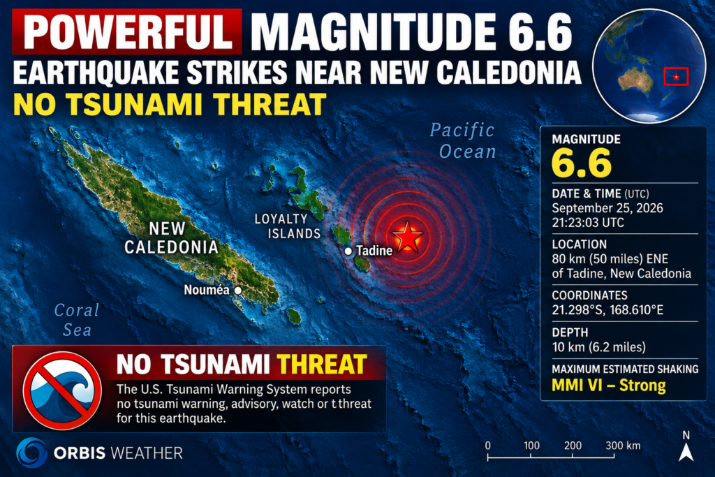
NEW CALEDONIA — September 26, 2026: A powerful magnitude 6.6 earthquake struck in the Pacific Ocean near New Caledonia early Saturday local time, according to the U.S. Geological Survey (USGS).
The earthquake occurred at 21:23:03 UTC on September 25, with the epicenter located approximately 80 kilometers (50 miles) east-northeast of Tadine, New Caledonia. USGS placed the hypocenter at a relatively shallow 10 kilometers (6.2 miles) beneath the surface. U.S. Geological Survey
USGS initially estimated the earthquake at magnitude 7.0 and a depth of 17.1 kilometers, but subsequent analysis revised the event downward to magnitude 6.6 and a depth of 10 kilometers. Reuters
🌎 Strong Shaking Possible Near New Caledonia
Despite the epicenter being offshore, an earthquake of this magnitude and shallow depth can produce significant shaking across nearby islands.
Preliminary USGS information lists a maximum estimated intensity of MMI VI — “Strong” shaking. At that intensity, people may have difficulty ignoring the shaking, unsecured objects can fall, and minor damage is possible in vulnerable structures. U.S. Geological Survey
The epicenter was near the Loyalty Islands, east of New Caledonia’s main island of Grande Terre.
As of the latest reports, there were no immediate reports of major casualties or widespread damage associated with the earthquake.
🌊 No Tsunami Threat
One of the biggest concerns following a strong, shallow earthquake beneath the Pacific is the possibility of a tsunami.
In this case, however, the U.S. Tsunami Warning System reported no tsunami warning, advisory, watch or threatassociated with the event. Tsunami.gov
Reuters reported that authorities determined the earthquake posed no tsunami threat to Hawaii, Guam, the Northern Mariana Islands or American Samoa. Reuters
That is encouraging news for communities throughout the Pacific.
📍 Earthquake Details
Magnitude: 6.6
Date: September 25, 2026 UTC / September 26 local time
Time: 21:23:03 UTC
Location: 80 km (50 miles) ENE of Tadine, New Caledonia
Coordinates: 21.298°S, 168.610°E
Depth: 10 km (6.2 miles)
Maximum estimated shaking: MMI VI — Strong
Tsunami threat: None reported U.S. Geological Survey
🌋 Why New Caledonia Is Earthquake Country
New Caledonia sits within a highly active part of the southwest Pacific, not far from the complex boundary between the Australian and Pacific tectonic plates.
The broader region stretching from New Zealand through Tonga, Vanuatu, New Caledonia, the Solomon Islands and Papua New Guinea experiences frequent earthquakes because of interactions among major tectonic plates and smaller crustal blocks.
Strong offshore earthquakes are therefore not unusual in this part of the Pacific.
⚠️ Aftershocks Are Possible
Aftershocks commonly follow earthquakes of magnitude 6.6 and can continue for days, weeks or longer.
At least one additional strong earthquake was detected in the area later Friday UTC. VolcanoDiscovery reported a magnitude 5.5 earthquake about 61 kilometers east-northeast of Tadine, although earthquake magnitudes and classifications can be revised as seismic networks analyze additional data. VolcanoDiscovery
Residents should remain prepared for additional shaking and follow instructions from New Caledonian authorities.
🛰️ Orbis Weather Will Continue Monitoring
The magnitude 6.6 New Caledonia earthquake was a significant seismic event, but the initial assessment is reassuring: no tsunami threat has been issued and no major damage has yet been reported.
The situation could still evolve as authorities assess communities closer to the epicenter and additional seismic data become available.
Orbis Weather will continue monitoring the New Caledonia region for aftershocks, damage reports and any changes to official tsunami information.
Sources: U.S. Geological Survey, U.S. Tsunami Warning System and Reuters. U.S. Geological Survey
🌏 Magnitude 6.6 Earthquake Strikes Indonesia’s Java Region
JAKARTA, Indonesia — September 12, 2026 — A powerful magnitude 6.6 earthquake struck near Indonesia’s Java region early Saturday local time, sending tremors across a wide area, including parts of Jakarta and West Java.
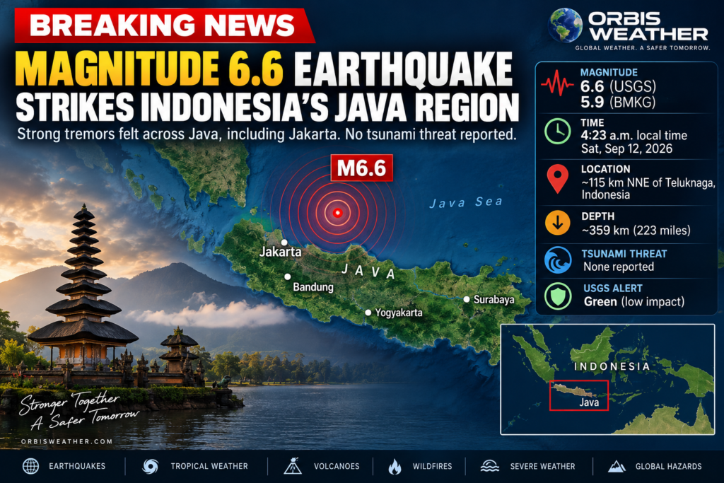
The U.S. Geological Survey recorded the earthquake at 21:23:55 UTC Friday (4:23 a.m. Saturday local time). The epicenter was about 115 kilometers (71 miles) north-northeast of Teluknaga, Indonesia, at an unusually deep 358.6 kilometers (223 miles) beneath the surface. (USGS)
📍 Earthquake Details
Magnitude: 6.6
Time: 4:23 a.m. local time, Saturday, September 12
Location: Approximately 115 km NNE of Teluknaga, Indonesia
Depth: About 359 km / 223 miles
USGS alert: 🟢 Green
Tsunami threat: None reported
The USGS estimated a maximum observed shaking intensity around MMI IV, or light shaking, consistent with the earthquake’s considerable depth. (USGS)
🌊 No Tsunami Threat
Indonesia’s BMKG measured the earthquake somewhat lower, at magnitude 5.9, placing the epicenter near the Thousand Islands northwest of Jakarta at a depth of approximately 376 kilometers.
BMKG said the earthquake did not have the potential to generate a tsunami. (iNews.ID)
Differences between initial USGS and BMKG magnitudes are not unusual, as seismic agencies use different monitoring networks and analysis techniques.
🏙️ Tremors Felt Across Java — and Beyond
Despite originating hundreds of kilometers underground, the earthquake was reportedly felt across a remarkably broad area.
BMKG reported shaking in locations including Bandung, Sukabumi, Cianjur, Garut, Yogyakarta, Pacitan, Ponorogo and Malang, along with areas farther west including portions of Bengkulu and West Sumatra. Most reports were in the MMI II–III range, meaning light shaking was noticeable indoors and hanging objects may have moved. (iNews.ID)
Deep earthquakes can sometimes be felt over very large areas because seismic waves travel efficiently through Earth’s interior.
🚨 No Major Damage Reported
As of the latest reports, there were no immediate reports of fatalities or significant structural damage.
The USGS issued a Green PAGER alert, indicating a low likelihood of major casualties or economic losses from the earthquake. (USGS)
That is encouraging considering the earthquake’s magnitude. Its extreme depth significantly reduced the intensity of shaking reaching the surface.
🌋 Indonesia Remains One of Earth’s Most Seismically Active Regions
Indonesia lies along the Pacific Ring of Fire, where several major tectonic plates interact. Earthquakes and volcanic eruptions are therefore common throughout the archipelago.
Friday’s earthquake was also one of several notable seismic events affecting Indonesia during the day. Earlier, a magnitude 6.2 earthquake struck the Banda Sea near Maluku, although that event was also deep and produced no tsunami threat or immediate damage reports. (Reuters)
🔴 ORBIS WEATHER EARTHQUAKE WATCH
Status: Monitoring
Magnitude: M6.6 USGS / M5.9 BMKG
Region: Java–Jakarta region, Indonesia
Depth: ~359–376 km
Tsunami: ✅ No threat
Major damage: None reported so far
Aftershocks: Possible
This is a developing story. Earthquake magnitude, depth and impact information can be revised as additional seismic data and damage assessments become available.
🌎 Magnitude 5.4 Earthquake Strikes Off Costa Rica as Multiple Tremors Shake Region
QUEPOS, COSTA RICA — September 10, 2026 — A magnitude 5.4 earthquake struck off Costa Rica’s Pacific coast early Thursday morning, shaking communities around Quepos, Dominical and other parts of the Central Pacific region and being felt farther inland.
According to Costa Rica’s Red Sismológica Nacional (RSN), the earthquake occurred at approximately 2:26 a.m. local time.
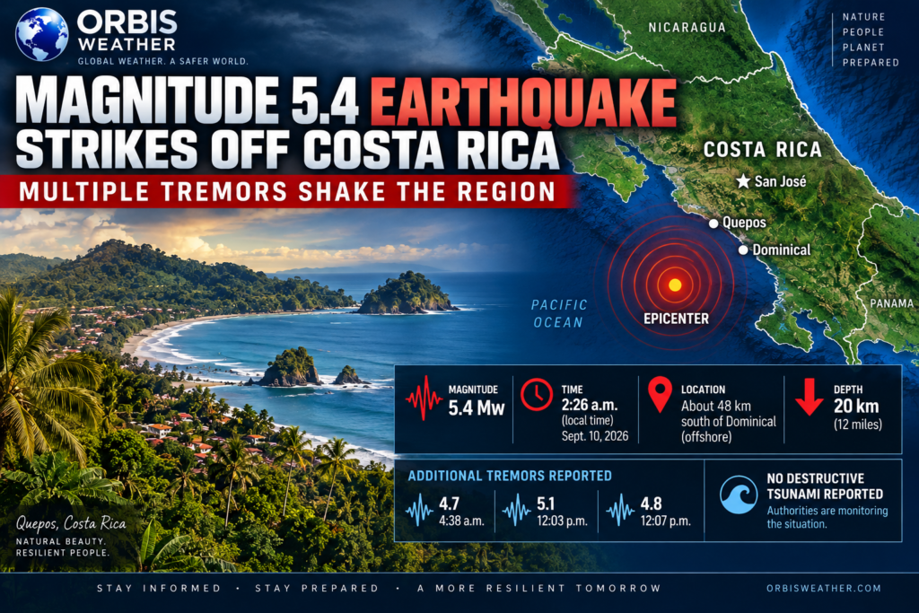
The RSN located the epicenter approximately 48 kilometers (30 miles) south of Dominical, beneath the Pacific Ocean. The earthquake had an estimated depth of 20 kilometers (12 miles).
📍 Earthquake Details
🌎 Magnitude: 5.4 Mw
🕑 Time: 2:26 a.m. local time
📅 Date: September 10, 2026
📍 Location: About 48 km south of Dominical, Costa Rica
⬇️ Depth: Approximately 20 km
🌊 Region: Pacific coast of Costa Rica
🧭 Coordinates: Approximately 8.899° N, 84.103° W
Costa Rica’s seismic network attributed the earthquake to the subduction of the Cocos Plate.
The Cocos Plate is being forced beneath the Caribbean Plate along the Middle America Trench, making Costa Rica one of the most seismically active countries in Central America.
⚠️ Multiple Earthquakes Reported
The early-morning M5.4 earthquake was not the only notable tremor recorded in Costa Rica on Thursday.
RSN listings indicated several additional felt earthquakes during the day, including events around magnitude 4.7, 5.1 and 4.8.
The sequence is likely to draw additional attention from seismologists as they examine the locations, depths and relationships between the earthquakes.
Aftershocks can occur following moderate earthquakes, and residents in affected areas should be prepared for additional shaking.
🏠 Shaking Felt Across the Region
Reports indicated that the earthquake was felt across portions of Costa Rica’s Central Pacific region and Central Valley.
Communities near Quepos and Dominical were among those relatively close to the offshore earthquake.
Moderate earthquakes at relatively shallow depths can produce noticeable shaking over a wide area, particularly in buildings and areas with softer soils.
As of the latest information available, there were no confirmed reports of widespread major damage or fatalities associated with the M5.4 earthquake.
🌊 No Destructive Tsunami Reported
There was also no indication of a destructive tsunami generated by the earthquake.
Earthquakes of this magnitude generally do not produce major tsunamis, although authorities monitor offshore earthquakes closely because Costa Rica sits beside an active subduction zone capable of producing much larger events.
Coastal residents should always follow official instructions if a strong or prolonged earthquake occurs near the Pacific coast.
🌋 Why Costa Rica Has So Many Earthquakes
Costa Rica sits along one of the most active tectonic boundaries in the Western Hemisphere.
Off the country’s Pacific coast, the Cocos tectonic plate moves beneath the Caribbean Plate, building enormous stresses within the Earth’s crust.
When portions of these faults suddenly move, the stored energy is released as earthquakes.
Most earthquakes in Costa Rica are relatively small, but the region is capable of producing powerful and damaging events.
🔴 Orbis Weather Monitoring the Earthquake Sequence
The September 10 earthquake activity will continue to be monitored, particularly following the M5.4 event and the additional moderate earthquakes recorded later in the day.
Residents who feel additional strong shaking should remember to Drop, Cover and Hold On, stay away from windows and damaged structures, and follow information issued by Costa Rican emergency and seismic authorities.
Orbis Weather will update this story if stronger earthquakes occur or authorities report significant damage, injuries or other impacts.
Developing story — earthquake magnitudes, depths and locations may be revised as additional seismic data are analyzed.
🌎 Terremoto de magnitud 5,4 sacude la costa de Costa Rica mientras múltiples temblores afectan la región
QUEPOS, COSTA RICA — 10 de septiembre de 2026 — Un terremoto de magnitud 5,4 se registró frente a la costa del Pacífico de Costa Rica durante la madrugada del jueves, sacudiendo comunidades cercanas a Quepos, Dominical y otras zonas del Pacífico Central, además de sentirse en sectores del interior del país.
Según la Red Sismológica Nacional (RSN) de Costa Rica, el terremoto ocurrió aproximadamente a las 2:26 a. m., hora local.
La RSN ubicó el epicentro aproximadamente 48 kilómetros (30 millas) al sur de Dominical, bajo las aguas del océano Pacífico. El terremoto tuvo una profundidad estimada de 20 kilómetros (12 millas).
📍 Detalles del terremoto
🌎 Magnitud: 5,4 Mw
🕑 Hora: 2:26 a. m., hora local
📅 Fecha: 10 de septiembre de 2026
📍 Ubicación: Aproximadamente 48 km al sur de Dominical, Costa Rica
⬇️ Profundidad: Aproximadamente 20 km
🌊 Región: Costa del Pacífico de Costa Rica
🧭 Coordenadas: Aproximadamente 8,899° N, 84,103° O
La red sísmica de Costa Rica atribuyó el terremoto a la subducción de la placa de Cocos.
La placa de Cocos se introduce por debajo de la placa del Caribe a lo largo de la Fosa Mesoamericana, lo que convierte a Costa Rica en uno de los países con mayor actividad sísmica de Centroamérica.
⚠️ Se registraron múltiples terremotos
El terremoto de magnitud 5,4 registrado durante la madrugada no fue el único movimiento sísmico notable ocurrido en Costa Rica durante el jueves.
Los registros de la RSN indicaron varios terremotos adicionales sentidos durante el día, incluidos eventos de aproximadamente magnitud 4,7, 5,1 y 4,8.
La secuencia probablemente atraerá la atención de los sismólogos mientras analizan las ubicaciones, profundidades y posibles relaciones entre los diferentes movimientos sísmicos.
Después de un terremoto moderado pueden producirse réplicas, por lo que los residentes de las zonas afectadas deben permanecer preparados ante la posibilidad de nuevos movimientos.
🏠 El temblor se sintió en varias zonas
Los reportes indicaron que el terremoto fue sentido en sectores de la región del Pacífico Central y el Valle Central de Costa Rica.
Las comunidades cercanas a Quepos y Dominical se encuentran entre las zonas relativamente próximas al epicentro del terremoto ocurrido mar adentro.
Los terremotos moderados que ocurren a profundidades relativamente bajas pueden generar movimientos perceptibles en una amplia zona, especialmente dentro de edificios y en áreas con suelos más blandos.
Hasta la información más reciente disponible, no se habían confirmado daños graves generalizados ni víctimas mortales relacionadas con el terremoto de magnitud 5,4.
🌊 No se reportó un tsunami destructivo
Tampoco había indicios de que el terremoto hubiera generado un tsunami destructivo.
Los terremotos de esta magnitud generalmente no producen grandes tsunamis. Sin embargo, las autoridades vigilan cuidadosamente los terremotos que ocurren frente a la costa debido a que Costa Rica se encuentra junto a una zona de subducción activa capaz de generar eventos sísmicos mucho más fuertes.
Los residentes de las zonas costeras siempre deben seguir las instrucciones oficiales si se produce un terremoto fuerte o prolongado cerca de la costa del Pacífico.
🌋 ¿Por qué Costa Rica registra tantos terremotos?
Costa Rica se encuentra sobre uno de los límites tectónicos más activos del hemisferio occidental.
Frente a la costa del Pacífico del país, la placa tectónica de Cocos se desplaza por debajo de la placa del Caribe, acumulando enormes tensiones en la corteza terrestre.
Cuando una parte de estas fallas se desplaza repentinamente, la energía acumulada se libera en forma de terremotos.
La mayoría de los terremotos registrados en Costa Rica son relativamente pequeños, pero la región tiene la capacidad de producir eventos sísmicos fuertes y potencialmente destructivos.
🔴 Orbis Weather monitorea la secuencia sísmica
Orbis Weather continuará monitoreando la actividad sísmica del 10 de septiembre, especialmente después del terremoto de magnitud 5,4 y de los movimientos moderados adicionales registrados durante el día.
Los residentes que sientan nuevos movimientos fuertes deben recordar la recomendación de agacharse, cubrirse y sujetarse, mantenerse alejados de ventanas y estructuras dañadas, y seguir las informaciones e instrucciones emitidas por las autoridades de emergencia y los organismos sismológicos de Costa Rica.
Orbis Weather actualizará esta información si se producen terremotos más fuertes o si las autoridades reportan daños significativos, personas heridas u otros impactos.
Esta es una noticia en desarrollo. Las magnitudes, profundidades y ubicaciones de los terremotos pueden ser revisadas a medida que se analicen nuevos datos sísmicos.
🚨 5.3 Magnitude Earthquake Strikes Nepal Days After Devastating Floods
MUSTANG, NEPAL — September 9, 2026 — A magnitude 5.3 earthquake struck northwestern Nepal Tuesday night, shaking the Himalayan region as the country continues recovering from the catastrophic flooding that devastated communities along the Nepal-Tibet border in late August.
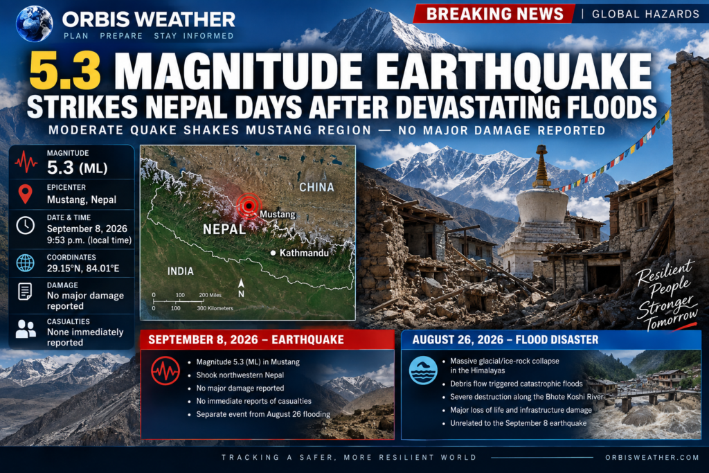
Nepal’s National Earthquake Monitoring and Research Center recorded the earthquake at 9:53 p.m. local time on September 8, placing the epicenter in Mustang District.
The monitoring center measured the earthquake at magnitude 5.3 ML, with coordinates of approximately 29.15°N, 84.01°E. Tremors were reported across parts of the surrounding Himalayan region.
As of the latest reports, there were no immediate reports of deaths, injuries or major structural damage from the earthquake. Authorities were continuing to assess conditions in the affected region.
🌎 Earthquake Strikes a Country Already Reeling From Disaster
The earthquake comes less than two weeks after the August 26 Bhote Koshi River flood disaster, which caused catastrophic destruction across parts of Nepal near the border with Tibet.
The two disasters should not be confused or directly linked.
The September 8 event was a genuine magnitude 5.3 earthquake recorded in Mustang.
The August 26 disaster, meanwhile, was a separate catastrophic flood caused by a massive collapse of ice, rock and debris in the Himalayas, which sent destructive material into the river system and unleashed a powerful flash flood downstream.
⚠️ August 26 “Earthquake” Was Actually a Glacial Collapse
There was significant confusion during the first hours of the August 26 disaster because seismic instruments detected a powerful signal near the Nepal-Tibet border.
Early information suggested an earthquake may have occurred shortly before the flooding.
However, subsequent analysis by the U.S. Geological Survey determined that the seismic energy was generated by the massive collapse itself — not by an earthquake.
The collapse of glacial ice, rock and debris produced vibrations strong enough to register on seismic monitoring equipment. The resulting debris flow entered the mountain river system and generated the catastrophic flooding downstream.
That distinction is particularly important following Tuesday night’s earthquake:
August 26: 🧊 Glacial/ice-rock collapse → debris flow → catastrophic flooding
September 8: 🌎 Confirmed magnitude 5.3 earthquake in Mustang
There is currently no confirmed evidence that the September 8 earthquake caused the August flooding, which occurred nearly two weeks earlier.
🌊 Nepal Still Recovering From August 26 Floods
Nepal remains in the middle of an enormous recovery and search operation following the August disaster.
The Government of Nepal said the Bhote Koshi River floods caused major loss of life, widespread displacement and extensive destruction of homes, roads, bridges, hydropower facilities and other critical infrastructure.
Among the areas affected were Rasuwa, Nuwakot and Dhading districts, along with communities farther downstream. Search, rescue and relief operations were still continuing into September.
The disaster began when a huge mass of ice, rock and debris collapsed in the high Himalayas near the Nepal-Tibet border. The material rushed into the river system, producing a fast-moving wall of water, mud and debris that tore through communities and transportation corridors.
Roads and bridges were destroyed, settlements were inundated and power infrastructure was severely damaged.
🏔️ Why Nepal Is So Vulnerable to Earthquakes
Nepal sits within one of the world’s most seismically active mountain regions.
The Himalayas were created — and continue to be shaped — by the collision of the Indian and Eurasian tectonic plates. Enormous geological pressure continues to accumulate along faults beneath the region, periodically producing damaging earthquakes.
Tuesday night’s magnitude 5.3 event was moderate compared with Nepal’s largest historical earthquakes, but even moderate shaking can be concerning in steep mountainous terrain.
Earthquakes can potentially destabilize already weakened slopes, triggering rockfalls and landslides, particularly in regions recently affected by flooding, erosion or heavy rainfall.
Officials will therefore be watching not only for structural damage but also for possible secondary hazards in mountainous areas.
🚨 Situation Being Monitored
For Nepal, the latest earthquake represents another natural hazard confronting a country already dealing with the consequences of one of its most destructive recent flood disasters.
The good news so far is that no major earthquake damage or casualties have been reported.
But with recovery operations from the August 26 floods still underway and Himalayan slopes remaining vulnerable to landslides and other hazards, authorities continue to monitor conditions closely.
🌎 ORBIS WEATHER — BREAKING EARTH UPDATE
Earthquake: Magnitude 5.3 ML
Date: September 8, 2026
Time: 9:53 p.m. Nepal time
Epicenter: Mustang, Nepal
Coordinates: 29.15°N, 84.01°E
Damage: No major damage immediately reported
Casualties: None immediately reported
Flood connection: No confirmed connection — the August 26 flooding was a separate disaster associated with a massive glacial/ice-rock collapse and debris flow.
Orbis Weather will continue monitoring earthquake activity, landslide hazards and the ongoing recovery from the August 26 Nepal flood disaster as additional information becomes available.
About the Author
Paul Harrison — Founder & Publisher, Orbis Weather
Paul Harrison founded Orbis Weather in 2026 to make global weather and natural-hazard information easier to find, follow and understand. His coverage includes tropical cyclones, severe weather, extreme temperatures, earthquakes, volcanoes, wildfires, flooding and significant natural disasters worldwide.
View all articles by Paul Harrison → | Editorial Standards →









Live Lightning Map
Live U.S. Wildfire Tracker

Live Wildfire Smoke & Air Quality Tracker

Live Earthquake Map
Live Volcano Eruption Tracker