Tropical Atlantic Daily Report: Wednesday, November 4, 2026
By Paul Harrison, Orbis Weather
Current to 6:47 AM EST (11:47 UTC), Wednesday, November 4, 2026. Based on the National Hurricane Center (NHC) Tropical Weather Outlook issued at 1:00 AM EST (0600 UTC) and the Tropical Weather Discussion issued at 0615 UTC on November 4.
At a glance
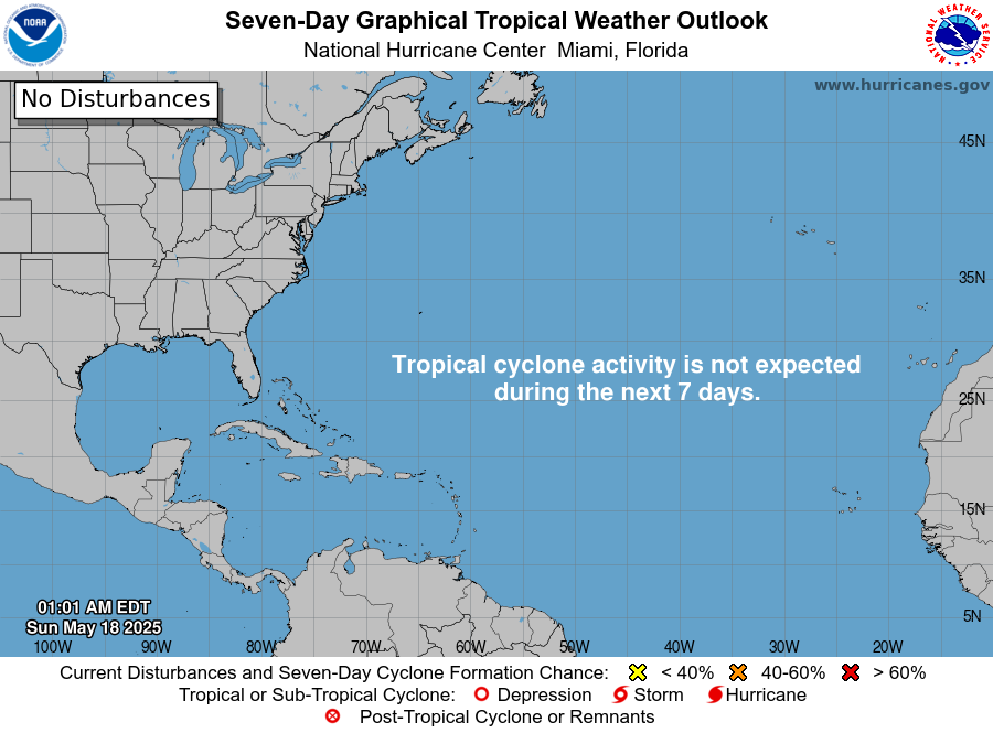
The Atlantic basin has no tropical cyclones this morning, and the only area NHC is watching is a developing low south of Bermuda.
- Active storms: none in the Atlantic, Caribbean Sea or Gulf of Mexico, and no tropical storm watches or warnings are in effect.
- Threat to land: no tropical cyclone threatens land. Separately, NHC’s discussion flags heavy rain and possible flash flooding and landslides over parts of Costa Rica, Panama and Nicaragua.
- Disturbance: a low expected to form south of Bermuda has a low (20 percent) chance of becoming a tropical or subtropical cyclone in 48 hours and a medium (40 percent) chance in 7 days.
- Season to date: 10 named storms, 1 hurricane and 1 major hurricane, below the 1991-2020 average for this date.
The National Hurricane Center and national weather services issue the official forecasts and warnings. Follow any evacuation order from local officials immediately.
Active storms
There are no tropical or subtropical cyclones and no potential tropical cyclones in the Atlantic basin, according to NHC’s 1:00 AM EST outlook. The most recent named storm, Subtropical Storm Josephine, existed from October 21 to 22.
Disturbances to watch
NHC outlines one area, a low expected to form south of Bermuda that could take on subtropical traits before conditions turn unfavorable early next week.
Area | Location | 48-hour chance | 7-day chance | NHC outlook issued |
|---|
Western and central Atlantic | A few hundred miles south of Bermuda, drifting slowly east | Low, 20% | Medium, 40% | 1:00 AM EST (0600 UTC) Nov 4 |
NHC says the low should form “over the next day or so along a weakening front” and “could gradually acquire some subtropical characteristics late this week or this weekend.” Whether or not it develops, gale-force winds are expected north of it, with seas of 10 to 16 feet (3 to 5 m) through Thursday, according to the Tropical Weather Discussion.
Elsewhere, the 0615 UTC discussion places a broad 1009 mb low over the southwest Caribbean near 12N 82W, which by those coordinates lies just off the coast of Nicaragua. It warns of heavy rain over southern and western Costa Rica, Panama and Nicaragua. In the Gulf of Mexico, a cold front entering the northwest Gulf is forecast to weaken and dissipate Wednesday night, with another front due Friday through Sunday night. The discussion does not mention Saharan dust or wind shear, and no outlook area is drawn in the Caribbean or the Gulf of Mexico.
Season so far
The 2026 season is running well below normal, with 3 fewer named storms and 5 fewer hurricanes than the 1991-2020 average to this point.
Measure | 2026 to date | 1991-2020 average to early November | 1991-2020 full-season average |
|---|
Named storms | 10 | 13 | 14 |
Hurricanes | 1 | 6 | 7 |
Major hurricanes (Category 3+) | 1 | 3 | 3 |
2026 counts and the departures from normal are from NHC’s season summary “as of 09 UTC 3 November 2026”; averages are from NHC’s 1991-2020 climatology. The only hurricane, Isaias (October 6 to 10), peaked at 105 knots (about 120 mph [195 km/h]) as a major hurricane. NHC puts total accumulated cyclone energy at 19.7, 83 percent below normal.
On ENSO, the Climate Prediction Center’s October 8 discussion keeps an El Niño Advisory in effect and says El Niño “continues to strengthen.”
What to watch next
- Low south of Bermuda, late this week into the weekend: NHC’s upcoming Tropical Weather Outlooks will show whether the low forms and gains subtropical traits.
- Gale conditions over the southwest North Atlantic, through the weekend: the National Weather Service High Seas Forecasts carry the gale warnings for mariners.
- Heavy rain in Costa Rica, Panama and Nicaragua, this week: national meteorological services in each country issue local flood and landslide alerts.
- Gulf of Mexico cold front, Friday through Sunday night: the National Weather Service will issue marine and coastal forecasts.
- ENSO update, November 12: the Climate Prediction Center’s next ENSO Diagnostic Discussion is scheduled for that date.
About this report
This report summarizes National Hurricane Center products and NOAA climate data available at 6:47 AM EST (11:47 UTC) on November 4, 2026. Times are given in EST and UTC, as NHC uses them in today’s products. Formation chances and conditions change with each new outlook, so readers should check NHC directly for the latest information. The report covers the Atlantic basin only; NHC also shows no tropical cyclones in the eastern or central North Pacific this morning.
Glossary
- Tropical Weather Outlook: NHC’s routine forecast of where tropical or subtropical cyclones could form, with chances for the next 48 hours and 7 days.
- Subtropical cyclone: a low-pressure system with a mix of tropical and non-tropical features, often forming along an old front.
- Major hurricane: a hurricane of Category 3, 4 or 5 on the Saffir-Simpson Hurricane Wind Scale.
- Accumulated cyclone energy (ACE): a measure of a season’s combined storm strength and duration.
- ENSO: the El Niño-Southern Oscillation, the cycle of warming (El Niño) and cooling (La Niña) in the tropical Pacific that affects weather worldwide.
Frequently asked questions
Are there any hurricanes or tropical storms in the Atlantic today? No. NHC’s 1:00 AM EST outlook lists no tropical cyclones in the Atlantic, the Caribbean Sea or the Gulf of Mexico, and no tropical storm or hurricane watches or warnings are in effect.
Could the low near Bermuda threaten Bermuda or the United States? NHC expects the low to move slowly eastward over the western and central subtropical Atlantic, and gives it a 40 percent chance of forming in 7 days. The outlook does not forecast impacts on land. Mariners should follow the gale warnings in the High Seas Forecasts.
Is hurricane season over? Not yet. NHC’s climatology states the Atlantic season runs from June 1 to November 30, and notes that storms sometimes form outside those dates.
Why has 2026 been so quiet? NHC’s season summary shows activity well below normal but does not give a cause. The Climate Prediction Center reports a strengthening El Niño, though the sources used here do not tie it to this season’s totals.
Sources
- National Hurricane Center home page, last updated 08:28 UTC Nov 4, 2026
- NHC Atlantic graphical outlook, 1:00 AM EST Nov 4, 2026
- NHC Atlantic Tropical Weather Outlook, issued 1:00 AM EST Nov 4, 2026
- NHC Tropical Weather Discussion, issued 0615 UTC Nov 4, 2026
- NHC 2026 North Atlantic season summary, as of 09 UTC Nov 3, 2026
- NHC tropical cyclone climatology, 1991-2020 normals
- CPC ENSO Diagnostic Discussion, issued Oct 8, 2026