
Powerful Pacific Storm Could Bring Tornadoes, Damaging Winds and Widespread Rain Across the United States
By Paul Harrison | Founder & Publisher, Orbis Weather

- Thailand Warns Eight Provinces of Possible Flooding as High Tides Threaten Bangkok and Coastal Communities 10:55 AM
- South America Weather & Natural Hazards Today — November 1, 2026 10:15 AM
- Central America Weather & Natural Hazards Today — Sunday, November 1, 2026 10:03 AM
- North America Weather & Natural Hazards Today Nov 1 9:46 AM
- Indonesia Forest Fire Haze Linked to More Than 3,500 Deaths in September as Air Pollution Crisis Deepens 8:37 AM
- Weekly Earth Watch: Volcanoes, Earthquakes & Natural Hazards – Week ending November 1, 2026 7:57 AM
- Daily Earthquakes, Storms, Fires & Floods Report — November 1, 2026 7:48 AM
- WESTERN PACIFIC Tropical Weather Update – November 1, 2026 7:34 AM
- Eastern & Central Pacific Tropical Weather Update: Sunday, November 1, 2026 7:27 AM
- Tropical Atlantic Daily Report: Sunday, November 1, 2026 7:20 AM
- Galápagos Islands Flood Disaster: One Dead, Two Missing as Torrential Rain Forces Families From Homes 5:26 AM
- Powerful Pacific Storm Could Bring Tornadoes, Damaging Winds and Widespread Rain Across the United States 5:07 AM





🌪️ Powerful Pacific Storm Could Bring Tornadoes, Damaging Winds and Widespread Rain Across the United States
Orbis Weather | By Paul Harrison | Sunday, November 1, 2026
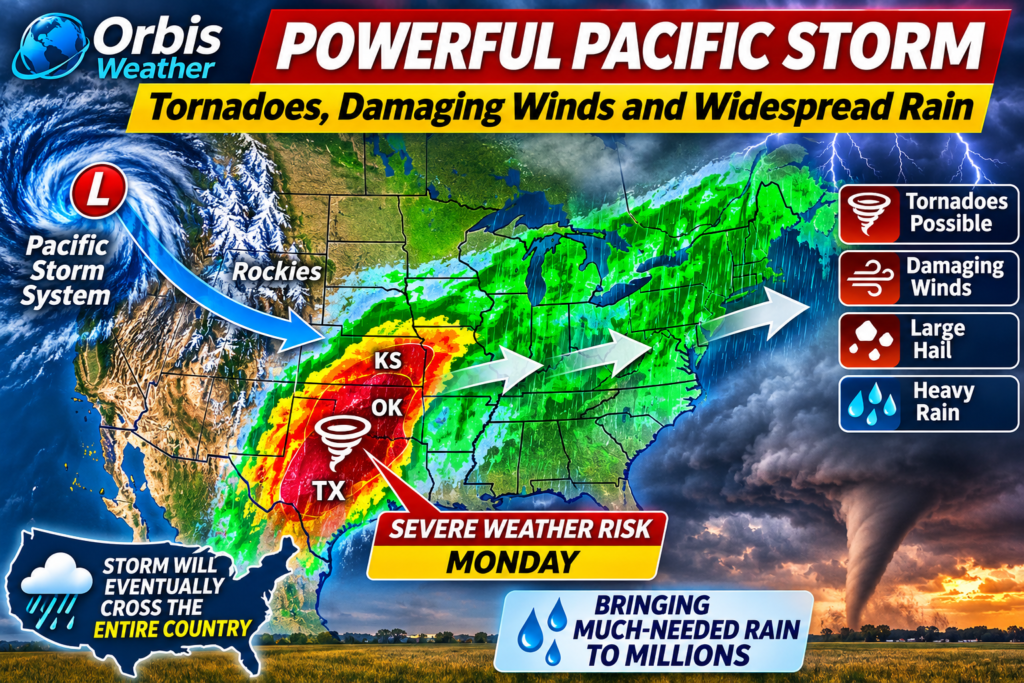
A powerful Pacific storm system is expected to strengthen as it crosses the Rocky Mountains, potentially setting the stage for severe thunderstorms, damaging winds and tornadoes across portions of Texas, Oklahoma and Kansas on Monday, November 2.
The developing weather system could eventually sweep eastward across much of the United States, bringing a combination of dangerous weather and much-needed rainfall to areas experiencing dry conditions.
While the prospect of widespread rain will be welcome for many communities, the immediate concern is the potential for severe thunderstorms across the southern and central Plains.
🌪️ Texas, Oklahoma and Kansas Face Potential Severe Weather
As the storm moves east of the Rockies, strengthening low pressure could draw warm, moisture-rich air northward from the Gulf of Mexico.
The interaction between this moisture, colder air aloft and powerful winds higher in the atmosphere could create an environment favorable for organized severe thunderstorms.
The principal threats may include:
🌪️ Tornadoes: Rotating thunderstorms could develop where atmospheric conditions support them.
💨 Damaging winds: Strong thunderstorm gusts could damage trees, power lines and buildings.
🧊 Large hail: Stronger thunderstorms may produce hail capable of damaging vehicles and property.
🌧️ Heavy rainfall: Intense downpours could cause localized flooding, particularly in poorly drained areas.
⚡ Frequent lightning: Thunderstorms may create hazardous conditions for outdoor activities.
The exact location and severity of these hazards will depend on how the storm evolves.
🚨 NOAA Confirms Level 2 Severe Weather Risk
The NOAA Storm Prediction Center’s November 1 outlook places much of Oklahoma, northern Texas and south-central and eastern Kansas under a Level 2 severe thunderstorm risk for Monday.
Forecasters expect thunderstorms to develop late Monday afternoon and continue into the evening. Damaging winds and a few tornadoes are the primary concerns.
🌧️ Storm Could Bring Welcome Rain to Millions
Beyond the severe weather threat, the storm is forecast to transport significant moisture across the central and eastern United States.
Rainfall could help relieve prolonged dry conditions across parts of the Plains, Midwest and eastern states.
However, some locations may receive too much rain in a short period, increasing the risk of flash flooding. The storm could also disrupt travel as it progresses eastward.
📅 What Happens Next?
Day | Expected developments |
|---|---|
Sunday, Nov. 1 | Storm system crosses the Southwest and Rockies, with rain and mountain snow |
Monday, Nov. 2 | Severe thunderstorm and tornado potential across Texas, Oklahoma and Kansas |
Tuesday, Nov. 3 | Rain and thunderstorms spread toward the Mississippi Valley and Midwest |
Wednesday onward | Storm-related precipitation may extend farther into the eastern United States |
The precise timing and coverage remain subject to forecast changes.
🛑 Safety Advice
Residents in the affected states should monitor forecasts from the NOAA Storm Prediction Center and their local National Weather Service office.
A tornado watch means conditions favor tornado development. A tornado warning means a tornado has been detected or is indicated by radar, requiring immediate protective action.
During a tornado warning, move to a basement or small interior room on the lowest floor of a sturdy building, away from windows.
🌎 Orbis Weather Outlook
This developing system illustrates the contrasting impacts of major autumn storms. While widespread rainfall could provide welcome relief from dry weather, the combination of strong winds, unstable air and Gulf of Mexico moisture creates a potentially dangerous severe weather environment across the central Plains.
The most important period to watch is Monday afternoon through Monday night, particularly across Oklahoma, northern Texas and Kansas.
Forecast information reviewed November 1, 2026. Severe weather outlooks are subject to change. Orbis Weather provides independent weather reporting and analysis and does not issue official weather warnings.
Sources: NOAA Storm Prediction Center, National Weather Service, AccuWeather.
About the Author
Paul Harrison — Founder & Publisher, Orbis Weather
Paul Harrison founded Orbis Weather in 2026 to make global weather and natural-hazard information easier to find, follow and understand. His coverage includes tropical cyclones, severe weather, extreme temperatures, earthquakes, volcanoes, wildfires, flooding and significant natural disasters worldwide.
View all articles by Paul Harrison → | Editorial Standards →
Global Weather Tracker Hub
Explore weather maps, tropical systems, storms and natural hazards around the world.
No matching trackers found.