
🌋 Mexico's Popocatépetl Volcano Sends Ash Toward 19,000 Feet as Aviation Advisory Issued
By Paul Harrison | Founder & Publisher, Orbis Weather

- Mexico’s Popocatépetl Volcano Sends Ash Toward 19,000 Feet as Aviation Advisory Issued 9:42 PM
- Singapore Lightning & Thunderstorms This Week — Wednesday, October 28, 2026 7:05 PM
- Southeast Asia Weather & Natural Hazards Today: Wednesday, October 28, 2026 6:52 PM
- King Tides Flood Streets on Both U.S. Coasts 3:39 PM
- Europe’s Cold Spots This Week Oct 27 2:39 PM
- WESTERN PACIFIC Tropical Weather Update – October 27, 2026 8:48 AM
- Eastern & Central Pacific Oct 27 8:38 AM
- Weekly Tropical Storm Tracker: Tuesday, October 27, 2026 8:23 AM
- Daily Earthquakes, Storms, Fires & Floods Report — October 27, 2026 8:14 AM
- Tropical Atlantic Daily Report: Tuesday, October 27, 2026 8:04 AM





🌋 Mexico’s Popocatépetl Volcano Sends Ash Toward 19,000 Feet as Aviation Advisory Issued
Volcanic ash emissions raise aviation concerns as authorities continue monitoring one of Mexico’s most active volcanoes.
By Paul Harrison | Orbis Weather
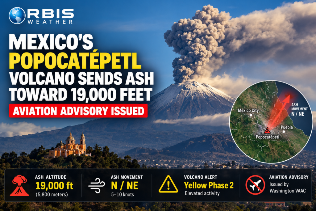
MEXICO — October 27, 2026: Mexico’s towering Popocatépetl volcano is once again drawing attention following volcanic ash advisories warning of ash emissions reaching approximately 19,000 feet (5,800 meters) above sea level.
The volcano, situated southeast of Mexico City, remains under close observation as authorities monitor gas emissions, volcanic tremors and ash plumes that can threaten aircraft operating near the mountain.
Although ash emissions are a familiar feature of Popocatépetl’s ongoing activity, the latest advisories highlight the continuing risks posed by one of North America’s most closely monitored volcanoes.
🌋 Why Popocatépetl matters
Rising approximately 17,800 feet (5,426 meters) above sea level, Popocatépetl is Mexico’s second-highest mountain and one of its most active volcanoes.
Located roughly 70 kilometers (43 miles) southeast of central Mexico City, it lies near densely populated communities in the states of Puebla, Morelos and México.
Known locally as El Popo, the volcano has experienced recurring eruptive activity since 1994, including ash emissions, explosions and the formation and destruction of lava domes.
Its proximity to major population centers makes even relatively modest ash-producing events important for public safety and aviation.
🚨 Latest volcanic activity: October 27
Mexico’s National Center for Disaster Prevention (CENAPRED) recorded 53 low-intensity exhalations during the 24-hour monitoring period ending Tuesday morning.
These emissions consisted primarily of water vapor and volcanic gases.
At 7:41 a.m. local time, monitoring equipment also detected a magnitude 1.3 volcano-tectonic earthquake, indicating minor seismic activity within the volcanic system.
Throughout the morning, observers reported continuous emissions of steam and gases drifting northeast from the summit.
CENAPRED’s monitoring data recorded no explosions during the reporting period.
✈️ Aviation advisory: Ash reaches approximately 19,000 feet
The Washington Volcanic Ash Advisory Center issued an advisory at 13:34 UTC on October 27 after satellite imagery confirmed continuing volcanic ash emissions.
The advisory placed the ash cloud’s upper boundary at approximately 19,000 feet (5,800 meters) above sea level, with ash moving northeast at around 10 knots (11.5 mph or 18.5 km/h).
A subsequent advisory at 19:23 UTC indicated that ash emissions might continue. However, meteorological clouds obscured the volcano, preventing direct confirmation of ash in satellite and webcam imagery at that time.
Forecasters expected the ash to drift north to north-northeast, with no volcanic ash forecast by 13:00 UTC on October 28 under the latest advisory model.
Why volcanic ash is dangerous to aircraft
Unlike ordinary smoke, volcanic ash consists of tiny fragments of rock, minerals and volcanic glass.
These particles can cause serious problems for aircraft, including engine damage, abrasion of cockpit windows, interference with sensors and reduced visibility.
Ash can also remain suspended in the atmosphere and travel considerable distances depending on wind speed and atmospheric conditions.
A volcanic ash advisory does not automatically mean airports are closed or flights have been canceled. Instead, it provides essential information to airlines, pilots and air traffic controllers so they can assess and avoid potentially hazardous airspace.
🟡 Volcano remains at Yellow Phase 2
Mexican authorities have maintained Popocatépetl’s volcanic alert status at Yellow Phase 2, reflecting ongoing activity that requires close monitoring.
Under this alert level, authorities identify several potential hazards:
🌋 Minor to moderate volcanic explosions.
🌫️ Light to moderate ashfall in nearby communities and potentially more distant cities.
🔥 Ejection of incandescent volcanic fragments close to the crater.
🌧️ Volcanic mudflows, known as lahars, particularly when heavy rain mixes with accumulated ash.
⚠️ Possible pyroclastic flows that are not expected to reach populated areas under the current alert scenario.
These are potential hazards associated with the alert level, not confirmation that each event is occurring.
CENAPRED continues to advise the public to remain outside the volcano’s 12-kilometer (7.5-mile) exclusion zone.
🏘️ Could ash affect Mexico City or Puebla?
The direction and intensity of volcanic ash emissions are important for communities surrounding Popocatépetl.
Depending on wind conditions, ash can reach populated areas in Puebla, Morelos, the State of México and occasionally Mexico City.
Ashfall can reduce air quality, irritate eyes and respiratory systems, contaminate uncovered water supplies and accumulate on buildings, roads and vehicles.
However, the October 27 aviation advisory does not establish that significant ashfall has occurred across these cities.
The reported north-to-northeast movement suggests that communities downwind of the volcano should pay particular attention to local civil protection updates.
Residents experiencing ashfall should limit unnecessary outdoor exposure, close windows, protect drinking water supplies and follow local health guidance.
🔬 Does this mean a major eruption is coming?
Not necessarily.
Popocatépetl has experienced prolonged periods of elevated volcanic activity over several decades. Small ash emissions, gas releases and occasional seismic events are consistent with its continuing unrest.
Scientists monitor several indicators to evaluate changes in volcanic behavior, including seismic activity, ground deformation, gas emissions, thermal observations and the frequency of explosions.
A single ash advisory or small earthquake is not sufficient to predict a major eruption.
The October 27 monitoring report recorded 53 exhalations compared with 60 the previous day, illustrating that activity can fluctuate over short periods.
Importantly, Mexican authorities have not raised the volcano above Yellow Phase 2 in the latest verified report.
🔭 What happens next?
The immediate focus is on whether ash emissions continue, whether wind conditions shift and whether seismic or explosive activity increases.
The Washington VAAC indicated that another advisory would be issued by approximately 01:30 UTC on October 28.
Meanwhile, CENAPRED continues its daily monitoring program in cooperation with the National Autonomous University of Mexico (UNAM).
Any significant changes in volcanic activity could prompt updated aviation advisories or civil protection recommendations.
🌎 Orbis Weather outlook
Popocatépetl’s latest activity demonstrates why volcanic hazards remain an important part of global weather and natural disaster monitoring.
Although the volcano is not currently showing confirmed signs of a major eruption, ash emissions can still affect aviation, air quality and communities surrounding the mountain.
The key development to watch over the next 24 hours is whether additional ash emissions occur and whether authorities maintain the current Yellow Phase 2 alert.
Orbis Weather will continue following official volcanic monitoring reports and aviation advisories as new information becomes available.
📡 Official sources and further information
Editorial note: This report is based on official CENAPRED monitoring observations and Washington VAAC aviation advisories issued October 27, 2026. Volcanic activity and ash forecasts can change rapidly. The latest official bulletin should be consulted for safety-critical decisions
About the Author
Paul Harrison — Founder & Publisher, Orbis Weather
Paul Harrison founded Orbis Weather in 2026 to make global weather and natural-hazard information easier to find, follow and understand. His coverage includes tropical cyclones, severe weather, extreme temperatures, earthquakes, volcanoes, wildfires, flooding and significant natural disasters worldwide.
View all articles by Paul Harrison → | Editorial Standards →
Global Weather Tracker Hub
Explore weather maps, tropical systems, storms and natural hazards around the world.
No matching trackers found.