
Major October Cold Snap: Freeze Warnings Across the U.S.
By Paul Harrison | Founder & Publisher, Orbis Weather
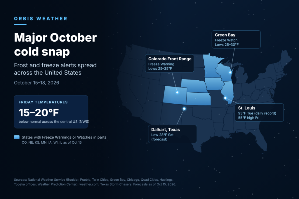

Major October Cold Snap: Frost and Freeze Alerts Spread Across the United States
By Paul Harrison, Orbis Weather
Thursday, October 15, 2026
A powerful cold front is ending a spell of record October heat across the central and eastern United States. Freeze Warnings and Freeze Watches now stretch from Colorado to Wisconsin. Many areas could see their first frost or freeze of the season this weekend.
The swing is sharp. St. Louis set a record high of 93°F [34°C] on Tuesday, October 13. By Friday, its forecast high is 55°F [13°C], according to weather.com. The National Weather Service’s Weather Prediction Center expects temperatures 15 to 20 degrees F [8 to 11 degrees C] below normal across the central US on Friday.
Saturday morning, October 17, is expected to be the coldest of the season so far for much of the Plains and Upper Midwest. The interior Northeast faces its coldest night on Saturday night. Warmth returns to most areas early next week.
Where the alerts are
Freeze alerts on Thursday covered parts of at least six states in the Plains and Upper Midwest, plus Colorado’s Front Range. Most Freeze Watches cover late Friday night into Saturday morning.
State | Alert | Area | Timing | Forecast lows | NWS office |
|---|---|---|---|---|---|
Colorado | Freeze Warning | Front Range urban corridor, including Greeley, Fort Collins and Boulder, into El Paso County | Midnight to 9 a.m. Friday | 25–35°F [-4 to 2°C] | Boulder, Pueblo |
Colorado | Freeze Watch | El Paso and Kiowa counties (Colorado Springs area) | Late Friday night into Saturday morning | Mid-20s to about 30°F [-4 to -1°C] | Pueblo |
Minnesota and Wisconsin | Freeze Watch | Central, southern and west-central Minnesota; northwestern and west-central Wisconsin | Late Friday night through Saturday morning | Below freezing possible | Twin Cities |
Wisconsin | Freeze Watch | 15 counties including Brown (Green Bay), Outagamie and Marathon | Late Friday night through Saturday morning | 25–30°F [-4 to -1°C] | Green Bay |
Illinois | Freeze Watch | Boone, Ogle and Winnebago counties (Rockford area) | Late Friday night through Saturday morning | As low as 30°F [-1°C] | Chicago |
Iowa and Illinois | Freeze Watch | 12 eastern Iowa counties, including Linn (Cedar Rapids) and Dubuque; three northwestern Illinois counties | Late Friday night through Saturday morning | As low as 30°F [-1°C] | Quad Cities |
Nebraska and Kansas | Freeze Watch | 24 south-central Nebraska counties, including Grand Island, Hastings and Kearney; six north-central Kansas counties | Late Friday night through Saturday morning | As low as 28°F [-2°C] | Hastings |
Kansas | Freeze Watch | 13 northeastern Kansas counties, including Riley (Manhattan) | Late Friday night through Saturday morning | As low as 31°F [-1°C] | Topeka |
Nebraska | Freeze Watch | Omaha area | Early Saturday | Near 30°F [-1°C] | Not stated (WOWT report) |
The NWS in Pueblo said Friday night into Saturday will be the coldest night and may end the growing season. NWS Boulder called it “the potential for the first freeze of the season for the plains!”
This was also Colorado’s first winter weather advisory of the season. Mountains above 9,000 feet [2,740 meters] were forecast to get 6 to 12 inches [15 to 30 cm] of snow, Colorado Public Radio reported.
Alerts can be upgraded or extended. Readers should check the latest products from their local NWS office at weather.gov.
How cold it gets
High temperatures will fall by 20 to 30 degrees F [11 to 17 degrees C] in a day in some cities. Lows will drop into the 20s and 30s in the northern Plains and Upper Midwest.
City | High before the front | High after the front | Coldest forecast low | Source |
|---|---|---|---|---|
Little Rock, Ark. | 93°F [34°C] Thu | 66°F [19°C] Fri | — | weather.com |
St. Louis, Mo. | 78°F [26°C] Thu | 55°F [13°C] Fri | — | weather.com |
Dallas, Texas | 89°F [32°C] Thu | 65°F [18°C] Fri | 50°F [10°C] Sat | weather.com; Texas Storm Chasers |
Washington, D.C. | 81°F [27°C] Fri | 56°F [13°C] Sat | 30s°F [about 0 to 4°C] Sat morning | weather.com |
New York City | 76°F [24°C] Fri | 54°F [12°C] Sat | 41°F [5°C] Sat night | NWS |
Minneapolis, Minn. | — | 52°F [11°C] Fri | 35°F [2°C] Fri night, frost in spots | NWS |
Topeka, Kan. | — | 55°F [13°C] Fri | Low to mid 30s°F [about 0 to 2°C] Sat | WIBW |
Amarillo, Texas | — | — | 32°F [0°C] Sat | Texas Storm Chasers |
Dalhart, Texas | — | — | 28°F [-2°C] Sat | Texas Storm Chasers |
NWS Chicago said: “Widespread frost is expected Friday night into Saturday across northern Illinois away from Lake Michigan.” Chicago itself is forecast to fall into the upper 30s, with below-freezing readings possible to the west, NBC Chicago reported.
In the Northeast, interior valleys of Pennsylvania, New York and northern New England could drop to the upper 20s and low 30s [about -3 to 1°C], according to FOX Weather. AccuWeather said a “killing frost or freeze” is possible on Saturday night in the interior Northeast and Upper Midwest, away from large lakes. As of Thursday afternoon, no Northeast freeze alerts had been issued.
Wind will make it feel colder. AccuWeather meteorologist Brett Anderson said: “Wind gusts will average 25-40 mph” from Friday into Saturday. NWS Chicago forecast gusts of 35 to 40 mph [56 to 64 km/h] on Friday.
Why it is happening
Forecasters attribute the change to a strong cold front carrying cooler air south and east from Canada. AccuWeather described the air mass as “Canadian air,” the coldest of the season so far. A storm is strengthening along the front as it moves from the Midwest toward the St. Lawrence Valley.
The front follows days of unusual heat. On Tuesday, October 13, daily records fell across the central US, according to NWS data compiled by The Watchers:
- St. Louis: 93°F [34°C], beating 90°F [32°C] from 1899
- Springfield, Mo.: 93°F [34°C], beating 88°F [31°C] from 2017
- Springfield, Ill.: 92°F [33°C], beating 88°F [31°C]
- Wichita, Kan.: 91°F [33°C], beating 90°F [32°C]
- Tulsa, Okla.: 92°F [33°C], tying the record from 1963
Chicago reached 88°F [31°C] on Monday, October 12, a daily record, WTTW reported. St. Louis fell 1°F short of its all-time October record of 94°F [34°C], set in 1953.
NWS St. Louis meteorologist Brad Charboneau described the jet stream as amplified. “It’s pretty unusual,” he told St. Louis Public Radio.
Weather.com meteorologist Rob Shackelford said: “A battle of the seasons is being waged in the Central U.S.” The East may still see record highs on Friday before the front arrives there.
How to protect plants, pipes and sprinklers
The main risk is to gardens, late crops and exposed outdoor plumbing. NWS freeze alerts warn: “Frost and freeze conditions could kill crops, other sensitive vegetation and possibly damage unprotected outdoor plumbing.”
NWS offices and local forecasters recommend these steps before Friday night:
- Bring in or cover tender plants. NWS Topeka advised: “Tender plants should be brought inside or covered.” Potted plants can be moved indoors.
- Harvest what you can. NWS Boulder told residents to “Protect or harvest cold sensitive vegetation.”
- Blow out or shut off sprinklers. “Bring in your plants and blow out your sprinklers,” NWS Boulder advised.
- Disconnect garden hoses. Omaha’s WOWT recommended disconnecting sprinklers and hoses.
- Protect exposed pipes. NWS Pueblo advised wrapping pipes, draining them, or letting them drip slowly.
In south-central Nebraska, the first freeze is arriving close to the usual date. The NWS in Hastings lists average first-freeze dates of October 11 for Kearney, October 12 for Grand Island and October 15 for Hastings, based on 1996–2025 records.
What comes next
The cold will be brief. Most areas warm back toward or above average early next week.
Day | What to expect |
|---|---|
Thursday night, Oct 15 | Freeze Warning on Colorado’s Front Range; cold front crosses Texas with gusts over 40 mph [64 km/h] on Friday, according to Texas Storm Chasers |
Friday, Oct 16 | Highs 15 to 20°F [8 to 11°C] below normal across the central US (WPC); possible record warmth in the East before the front arrives; strong storms possible in the mid-Atlantic in the afternoon and evening |
Saturday morning, Oct 17 | Coldest morning of the season so far across the Plains and Upper Midwest; freeze possible under the Freeze Watches |
Saturday night into Sunday, Oct 18 | Frost or freeze possible in the interior Northeast; Sunday expected to be the coolest morning of the season in Dallas-Fort Worth, CBS Texas reported |
Early next week | Upper Midwest above average by Sunday (weather.com); Minneapolis highs 66–70°F [19–21°C] Sunday to Wednesday (NWS); Topeka in the 70s°F [21–26°C] from Monday (WIBW); Dallas back in the 80s°F [27–32°C] by midweek (CBS Texas) |
Snow is mostly limited to high ground. AccuWeather said flakes are possible in the Adirondacks, Green Mountains and White Mountains. Any accumulation would be small and slushy, mainly on grass and other unpaved surfaces.
Frequently asked questions
What is the difference between a Freeze Watch and a Freeze Warning? A Freeze Watch means sub-freezing temperatures are possible. A Freeze Warning means a freeze is expected. Most of this week’s alerts in the Midwest are watches, which may be upgraded before Friday night.
Which night will be coldest? For the Plains, Upper Midwest and Colorado, Friday night into Saturday morning. For the interior Northeast and much of the South, Saturday night into Sunday morning.
Will my garden survive? Tender plants left uncovered where temperatures drop below freezing are at risk. The NWS in Pueblo said the freeze may end the growing season there. Covering plants or bringing them indoors on Friday evening gives the best protection.
Is this cold unusual for mid-October? Not in the northern Plains. In south-central Nebraska, the average first freeze falls between October 11 and 15. The contrast is what stands out: some cities set record highs earlier this week.
Will it snow? Colorado’s mountains above 9,000 feet [2,740 meters] were forecast to get 6 to 12 inches [15 to 30 cm]. In the Northeast, AccuWeather expects only light, slushy amounts on higher ground.
How long will the cold last? Only a few days. Forecasts show highs returning to the 60s and 70s°F [16 to 26°C] across much of the Midwest early next week.
About the Author
Paul Harrison — Founder & Publisher, Orbis Weather
Paul Harrison founded Orbis Weather in 2026 to make global weather and natural-hazard information easier to find, follow and understand. His coverage includes tropical cyclones, severe weather, extreme temperatures, earthquakes, volcanoes, wildfires, flooding and significant natural disasters worldwide.
View all articles by Paul Harrison → | Editorial Standards →
Global Weather Tracker Hub
Explore weather maps, tropical systems, storms and natural hazards around the world.
No matching trackers found.