Tropical Atlantic Daily Report: Tuesday, November 10, 2026
By Paul Harrison, Orbis Weather
At a glance
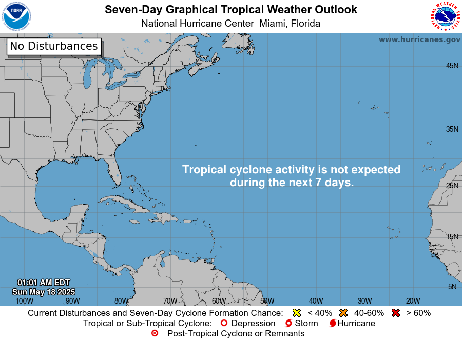
The Atlantic basin is quiet: no tropical storms are active and the National Hurricane Center (NHC) does not expect any to form in the next seven days.
This report is current to 6:50 AM EST (11:50 UTC) on Tuesday, November 10, 2026. It uses the NHC Atlantic Tropical Weather Outlook issued at 1:00 AM EST (06:00 UTC) on November 10, and the Atlantic Tropical Weather Discussion issued at 12:15 UTC on Monday, November 9.
- Active storms: none in the Atlantic, Caribbean Sea or Gulf of Mexico.
- Threats to land: none from tropical cyclones. No storm has watches, warnings or a forecast landfall.
- Disturbances: none. NHC’s outlook says “Tropical cyclone formation is not expected during the next 7 days.”
- Non-tropical weather: a gale-force low far out in the central Atlantic and cold fronts heading for the Gulf of Mexico and northwest Caribbean later this week.
- Season to date: 10 named storms, 1 hurricane and 1 major hurricane, all below the 1991-2020 normal for this date.
The National Hurricane Center and national weather services issue the official forecasts and warnings. Follow any evacuation order immediately.
Active storms
There are no active tropical or subtropical cyclones, or potential tropical cyclones, in the Atlantic basin. NHC has no Atlantic advisories in effect. The most recent named system, Subtropical Storm Josephine, lasted from October 21 to 22, according to NHC’s season list.
Disturbances to watch
NHC is not tracking any disturbance with a chance of becoming a tropical cyclone.
Area | Location | 48-hour chance | 7-day chance | NHC outlook issued |
|---|
None | North Atlantic, Caribbean Sea and Gulf of Mexico | None listed | None listed | 1:00 AM EST (06:00 UTC) Tue, Nov 10 |
The November 9 Tropical Weather Discussion lists no tropical waves; the ITCZ runs from near 8N 20W to 6N 55W. Its main feature is a non-tropical 997 mb low near 30N 49W, under a gale warning and moving northeast at 10 to 15 kt (12 to 17 mph [19 to 28 km/h]). NHC also expects a cold front to enter the northwest Gulf of Mexico on Thursday and possibly the northwest Caribbean on Friday, followed there by moderate to fresh winds and building seas.
Season so far
The 2026 season is running well below normal, with one hurricane against a normal of six by this date. NHC’s season list puts accumulated cyclone energy (ACE) at 19.9 units, 83% below normal.
Measure | 2026 to date | 1991-2020 normal to date | 1991-2020 full-season average |
|---|
Named storms | 10 | 13 | 14 |
Hurricanes | 1 | 6 | 7 |
Major hurricanes (Category 3+) | 1 | 3 | 3 |
The 2026 counts and the normal to date come from NHC’s 2026 season list, as of 03 UTC November 10, which shows each count against the normal. Full-season averages come from NHC climatology. The only hurricane was Isaias (October 6 to 10), which peaked at 105 kt (120 mph [195 km/h]) and 959 mb.
The NOAA Climate Prediction Center’s October 8 discussion keeps an El Niño Advisory in effect and says a strong-to-very strong El Niño is likely through January-March 2027.
What to watch next
The next few days hold marine weather, not tropical threats.
- Later today: NHC’s next Atlantic Tropical Weather Outlook will confirm whether the seven-day formation outlook stays empty.
- Tonight: the central Atlantic gale-force low is expected to move east of 35W by Tuesday night, according to NHC’s Tropical Weather Discussion.
- Thursday: NHC expects the next cold front to move into the northwest Gulf of Mexico. Local National Weather Service offices issue coastal forecasts.
- Friday: the front may reach the northwest Caribbean, and a stronger front is due in the northwest part of NHC’s Atlantic forecast waters at the end of the week.
- Thursday, November 12: the NOAA Climate Prediction Center is scheduled to issue its next ENSO discussion.
About this report
This report draws on National Hurricane Center (NHC) products, NHC season and climatology pages, and the NOAA Climate Prediction Center. Times are given in Eastern Standard Time (EST) and Coordinated Universal Time (UTC), as NHC uses them. NHC’s Tropical Weather Discussion dates from 12:15 UTC on November 9 and may not reflect changes since. The report summarizes official products and does not replace them; Orbis Weather covers the Pacific basins in separate reports.
Glossary
- Tropical Weather Outlook: NHC’s regular product giving the chance that a disturbance becomes a tropical cyclone within 48 hours and seven days.
- Tropical wave: a trough of low pressure moving westward across the tropics, which can seed tropical storms.
- ITCZ (Intertropical Convergence Zone): a band near the equator where trade winds meet, producing clusters of showers and thunderstorms.
- Accumulated cyclone energy (ACE): a measure of a season’s combined storm strength and duration.
- Major hurricane: a hurricane of Category 3 or higher on the Saffir-Simpson scale, with winds of at least 111 mph (179 km/h).
Frequently asked questions
Is any tropical storm threatening land today? No. There are no active Atlantic tropical cyclones and no watches or warnings. NHC does not expect a tropical cyclone to form in the next seven days.
What is the storm in the central Atlantic? It is a non-tropical low of 997 mb near 30N 49W, far from land. NHC carries a gale warning for it because of strong winds over open water. It is expected to move east of 35W by Tuesday night.
Why is the basin so quiet? NHC’s climatology shows most Atlantic activity falls between mid-August and mid-October, with the peak on September 10. By mid-November, an average season is in its final stretch. NHC’s outlook does not name a specific cause for this week’s quiet.
How does 2026 compare with an average season? It is below normal on every count. NHC lists 10 named storms and 1 hurricane, against a normal of 13 and 6 by this date. Season energy (ACE) is 83% below normal.
Sources
- NHC Atlantic Tropical Weather Outlook (graphical outlook page), issued 1:00 AM EST Tue, Nov 10, 2026
- NHC Atlantic Tropical Weather Outlook (text), copy served issued Mon, Nov 9, 2026 (superseded by the above)
- NHC Atlantic Tropical Weather Discussion, issued 12:15 UTC Mon, Nov 9, 2026
- National Hurricane Center home page, last updated 13:30 UTC Mon, Nov 9, 2026
- NHC 2026 Atlantic season list, as of 03 UTC Nov 10, 2026
- NHC tropical cyclone climatology, 1991-2020, undated reference page
- NOAA CPC ENSO Diagnostic Discussion, issued Oct 8, 2026