
Weekly Global Volcano Report
By Paul Harrison | Founder & Publisher, Orbis Weather
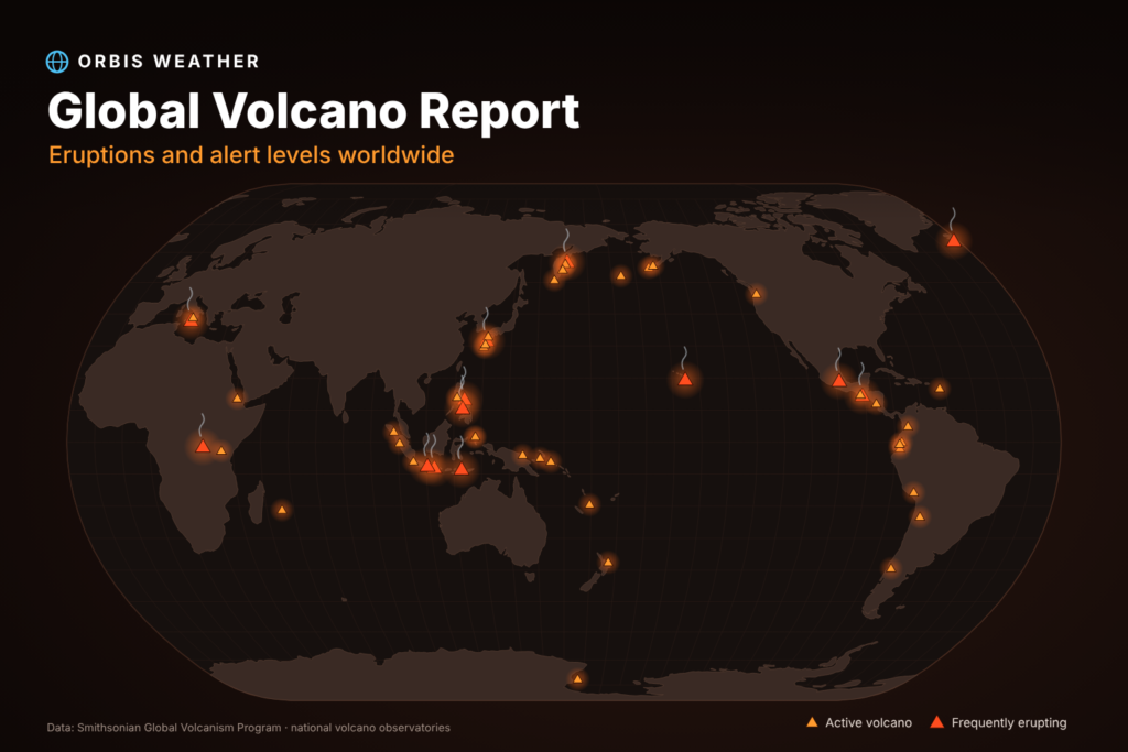






Global Volcano Report — November 2–8, 2026
· @Paul
By Paul Harrison, Orbis Weather
Summary
Kīlauea in Hawaii produced the week’s largest eruption: episode 56 sent lava fountains up to about 200 m (660 ft) high on November 5, with a plume to about 5,500 m (18,000 ft). In Indonesia, Semeru sent pyroclastic flows (fast avalanches of hot gas and rock) about 5 km down its southeast flank on November 6. In the Philippines, Mayon stayed at Alert Level 3 after its October 30 eruption and emitted an ash plume 1,600 m high on November 3.
Volcano | Country | What happened | Date (2026) |
|---|---|---|---|
Kīlauea | United States (Hawaii) | Episode 56 lava fountaining, about 6 hours; fountains about 200 m (660 ft), plume about 5,500 m (18,000 ft) above sea level; ash fell on Highway 11 | Nov 5 (HST) |
Semeru | Indonesia | Two eruptions with pyroclastic flows about 5 km southeast along Besuk Kobokan; ash 500–1,000 m above the summit | Nov 6 |
Semeru | Indonesia | Three eruptions; pyroclastic flows 3–4.5 km; ash about 700 m above the summit | Nov 5 |
Mayon | Philippines | Ash emission from 08:22 local time, plume 1,600 m above the crater, drifting southwest | Nov 3 |
Dukono | Indonesia | Eruption at 12:15 local time; 12 eruption earthquakes that day | Nov 3 |
Shishaldin | United States (Alaska) | Alert lowered to Normal/Green as unrest fell to near-background levels | Nov 2 |
Active volcanoes this week
Twenty-five volcanoes are listed, grouped by region (Alaska, Europe and Iceland, Hawaii and the western Pacific, Indonesia, Japan, Latin America, the Philippines, Russia). Rows marked (pre-window) have no checked report from November 2–8; they are kept because their last stated alert was elevated. Most of those dates come from the Smithsonian/USGS weekly report for October 8–14, the newest issue available.
Volcano | Country | Alert level (scale, date) | Latest activity |
|---|---|---|---|
Great Sitkin | United States (Alaska) | Watch / Orange (USGS, 4 levels each; Nov 7) | Slow lava eruption continues inside the summit crater (Nov 7). |
Shishaldin | United States (Alaska) | Normal / Green (USGS; lowered Nov 2) | Unrest fell to near-background levels; no eruption (Nov 2). |
Etna (pre-window) | Italy | Yellow (Civil Protection, 2nd of 4; Oct 5–11) | Gas and minor ash at Northeast Crater (Oct 5–11). INGV issued an aviation notice on Nov 8 that could not be read. |
Stromboli (pre-window) | Italy | Yellow (Civil Protection, 2nd of 4; Oct 5–11) | Ordinary Strombolian activity (short bursts of lava and gas) at both crater areas, medium frequency; no lava flows (INGV bulletin for Oct 26–Nov 1, issued Nov 3). |
Svartsengi / Sundhnúkur (pre-window) | Iceland | Level 2, orange (IMO hazard scale; Oct 27) | Ground uplift and magma build-up continue; an intrusion or eruption is the most likely next step (Oct 27). |
Ahyi Seamount | United States (Northern Mariana Islands) | Advisory / Yellow (USGS; Nov 6) | Underwater volcano under elevated status; no new event reported (Nov 6). |
Kīlauea | United States (Hawaii) | Advisory / Yellow (USGS; Nov 8) | Episode 56 fountaining on Nov 5; eruption paused since, next episode likely weeks away (Nov 8). |
Dukono | Indonesia | Level 2 (PVMBG, 1–4; Nov 3) | Eruption at 12:15 local time; fifth in a week; plume not observed (Nov 3). |
Ibu (pre-window) | Indonesia | Level 2 (PVMBG, 1–4; Oct 1–7) | Daily ash plumes 200–800 m above the summit (Oct 1–7). |
Karangetang (pre-window) | Indonesia | Level 2 (PVMBG, 1–4; Oct 14) | Dense white plumes up to 1 km above the summit (Oct 14). |
Krakatau (pre-window) | Indonesia | Level 3 (PVMBG, 1–4; raised Oct 9) | Small ash plumes, nine eruptive events on Oct 9. |
Lewotolok (pre-window) | Indonesia | Level 2 (PVMBG, 1–4; Oct 14) | Lava flows 400–600 m long on the south and southeast flanks (Oct 8–14). |
Merapi (pre-window) | Indonesia | Level 3 (PVMBG, 1–4; Oct 8–14) | Lava avalanches from the dome up to 2 km down southwest drainages (Oct 8–14). |
Semeru | Indonesia | Level 3, Siaga (PVMBG, 1–4; Nov 6) | Pyroclastic flows about 5 km southeast; ash up to 1,000 m above the summit (Nov 6). |
Aira (Sakurajima) (pre-window) | Japan | Level 3 (JMA, 1–5; Oct 5–8) | 15 eruptions, ash 1–1.6 km above Minamidake Crater (Oct 5–8). |
Suwanosejima (pre-window) | Japan | Level 2 (JMA, 1–5; Oct 7–8) | Ash up to 400 m above Ontake Crater (Oct 7–8). |
Nevados de Chillán (pre-window) | Chile | Yellow (SERNAGEOMIN, 2nd of 4; Oct 8–14) | New summit lava flow; ash up to 860 m above the summit (Oct 8). |
Popocatépetl | Mexico | Yellow Phase 2 (CENAPRED, 3 colours; Nov 8) | 35 emissions of gas and steam in 24 hours (Nov 8). |
Puracé (pre-window) | Colombia | Yellow (SGC, 2nd of 4; Oct 8–14) | Daily ash plumes to 5.1–6.1 km (17,000–20,000 ft) above sea level (Oct 8–14). |
Sabancaya (pre-window) | Peru | Orange (IGP, 3rd of 4; Oct 5–11) | Gas and ash up to 800 m above the summit; no explosions (Oct 5–11). |
Bulusan (pre-window) | Philippines | Level 1 (PHIVOLCS, 0–5; Oct 30) | No activity details in the checked listing. |
Kanlaon (pre-window) | Philippines | Level 2 (PHIVOLCS, 0–5; Oct 30) | Probable magma intrusion at depth; entry to the 4 km Permanent Danger Zone barred (Oct 30). |
Mayon | Philippines | Level 3 (PHIVOLCS, 0–5; Nov 3) | Ash plume 1,600 m above the crater, drifting southwest (Nov 3); Strombolian burst with a 300 m plume (Nov 2). |
Taal (pre-window) | Philippines | Level 1 (PHIVOLCS, 0–5; Oct 30) | Whole volcano island is a Permanent Danger Zone (Oct 30). |
Sheveluch (pre-window) | Russia | Orange (KVERT aviation code, 2nd highest of 4; Oct 7–14) | Lava dome growth and explosions (Oct 7–14). |
New or changed alerts
Three changes were found, all from the US Geological Survey (USGS). No checked agency outside the United States changed a level during the week.
- Kīlauea (HVO/USGS), raised: aviation code Yellow to Orange (alert level Advisory to Watch) on November 2 after low-level lava began at the summit at 11:43 a.m. HST; notice issued 00:06 UTC November 3.
- Kīlauea (HVO/USGS), lowered: Orange to Yellow (Watch to Advisory) at 00:50 UTC November 7, after no eruptive activity followed the end of episode 56.
- Shishaldin (AVO/USGS), lowered: aviation code Yellow to Green at 22:29 UTC November 2, as unrest fell to near-background levels.
Just before the window, PHIVOLCS raised Mayon to Alert Level 3 on October 30 after a moderately explosive eruption; the previous level was not stated in the sources read.
About this report
This report summarises agency bulletins and news reports for November 2–8, 2026 (UTC); it is not an official warning, so follow local authorities for safety decisions. Alert scales differ by country: Indonesia uses levels 1–4, the Philippines 0–5, Japan 1–5, Mexico a three-colour “traffic light” with phases, and the United States a ground alert (Normal, Advisory, Watch, Warning) plus an aviation colour code (Green to Red), so the same number can mean different things. The Smithsonian/USGS weekly report available on November 9 covered only October 8–14, and Russia’s KVERT, Japan’s JMA and Guatemala’s INSIVUMEH could not be checked for this week, so several statuses are older than the week and are marked with their dates.
Sources
- Smithsonian/USGS Weekly Volcanic Activity Report RSS (covers Oct 8–14, 2026)
- USGS Volcano Hazards Program — Volcano Updates
- USGS Kīlauea volcano updates (Nov 8, 2026)
- USGS Volcano Hazards Program
- Fox Weather: Kīlauea episode 56 (Nov 6, 2026)
- Big Island Video News: Kīlauea update, Nov 4, 2026
- Metro TV News: Semeru, Nov 6, 2026
- Metro TV News: Semeru, Nov 5, 2026
- Databoks/Katadata: Dukono, Nov 3, 2026
- GMA News: Mayon emits ash anew (Nov 3, 2026)
- The Manila Times: Mayon heightened activity (Nov 2, 2026)
- CGTN: Mayon ash emission (Nov 3, 2026)
- GeoRisk PH HazardHunter: PHIVOLCS volcano alert status
- Infobae: Popocatépetl, Nov 8, 2026
- INGV Stromboli weekly bulletin, Oct 26–Nov 1, 2026
- EtnaMonitor (unofficial; links INGV notice of Nov 8)
- Icelandic Met Office: Svartsengi magma accumulation (updated Oct 27, 2026)
About the Author
Paul Harrison — Founder & Publisher, Orbis Weather
Paul Harrison founded Orbis Weather in 2026 to make global weather and natural-hazard information easier to find, follow and understand. His coverage includes tropical cyclones, severe weather, extreme temperatures, earthquakes, volcanoes, wildfires, flooding and significant natural disasters worldwide.
View all articles by Paul Harrison → | Editorial Standards →
Global Weather Tracker Hub
Explore weather maps, tropical systems, storms and natural hazards around the world.
No matching trackers found.