
Weekly Global Earthquake Report (M4.5+)
By Paul Harrison | Founder & Publisher, Orbis Weather
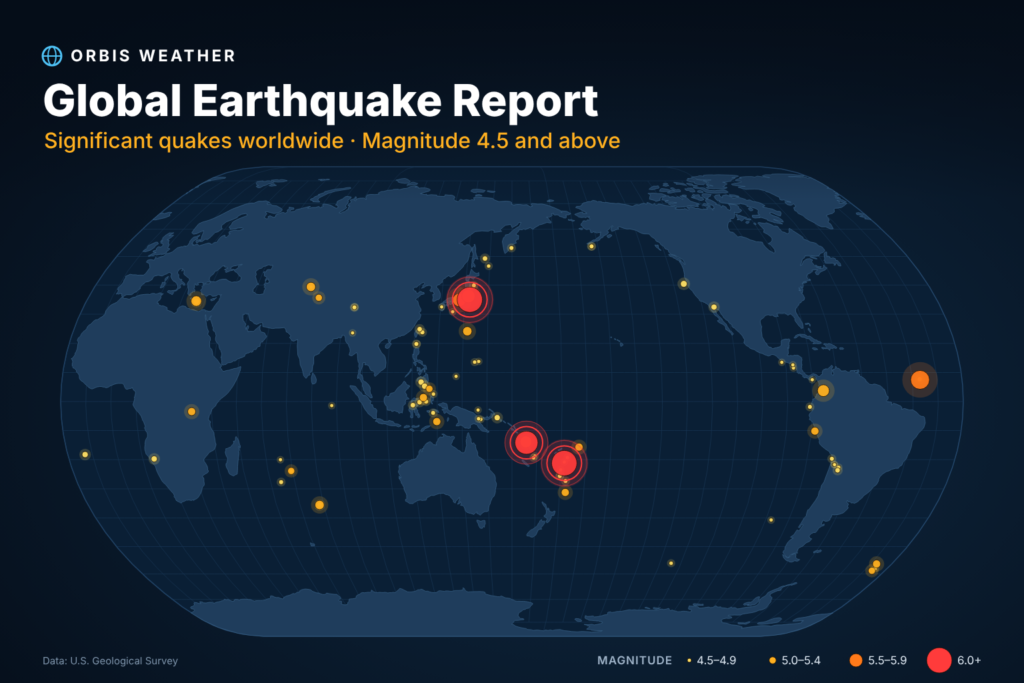






Global Earthquake Report — November 1–8, 2026 (M4.5+)
· @Paul
By Paul Harrison, Orbis Weather
Summary
The US Geological Survey (USGS) recorded 100 earthquakes of magnitude 4.5 or greater worldwide between 00:00 UTC on November 1 and 00:00 UTC on November 9, 2026. Three reached magnitude 6 or above, and none caused a yellow, orange or red alert on USGS’s PAGER impact scale.
Largest events | Magnitude | Time (UTC) | Depth |
|---|---|---|---|
144 km SE of Hasaki, Japan | 6.1 | Nov 6, 10:39 | 29.0 km |
Fiji region | 6.1 | Nov 5, 17:21 | 535.0 km |
165 km NW of Port-Olry, Vanuatu | 6.0 | Nov 1, 11:47 | 10.0 km |
Central Mid-Atlantic Ridge | 5.8 | Nov 7, 23:17 | 10.0 km |
- Japan: the most active area, with 11 events. They include two M5.5 quakes near Hasaki and Hamakita on November 7, a day after the M6.1 offshore.
- Vanuatu: the M6.0 on November 1 was part of a cluster of five other M4.7–5.4 quakes in the same area within about six hours.
- Crete, Greece: four quakes of M4.5–5.3 struck 81–101 km south-southeast of Palekastro between November 2 and 6.
- Tsunami: USGS’s tsunami flag is set on one event, the M4.96 off Petrolia, California, on November 5. The flag means the quake was in a region where tsunami information is issued; it does not mean a tsunami occurred.
Twenty-six of the 100 events are exactly M4.5. Magnitudes come from different methods (mb, mww, mwr, mw), so small differences between events are not significant.
Earthquake list
All 100 events, newest first. Each magnitude links to its USGS event page; the letters after it are the magnitude method.
Time (UTC) | Magnitude | Location (USGS) | Depth (km) |
|---|---|---|---|
Nov 8, 20:16 | 43 km E of Onagawa Chō, Japan | 55.7 | |
Nov 8, 16:45 | 117 km NE of Tobelo, Indonesia | 224.6 | |
Nov 8, 16:33 | central Mid-Atlantic Ridge | 10.0 | |
Nov 8, 12:29 | Southwest Indian Ridge | 10.0 | |
Nov 8, 11:58 | 46 km NW of Huara, Chile | 68.8 | |
Nov 8, 09:23 | 137 km E of Miyako, Japan | 10.0 | |
Nov 8, 01:53 | 11 km W of Honmachi, Japan | 10.0 | |
Nov 7, 23:27 | 91 km ENE of Hihifo, Tonga | 10.0 | |
Nov 7, 23:25 | 41 km WSW of Gadung, Philippines | 607.0 | |
Nov 7, 23:22 | 77 km SW of La Gomera, Guatemala | 34.2 | |
Nov 7, 23:17 | central Mid-Atlantic Ridge | 10.0 | |
Nov 7, 20:55 | 43 km ESE of Ambon, Indonesia | 136.7 | |
Nov 7, 19:55 | 65 km WSW of Masachapa, Nicaragua | 37.1 | |
Nov 7, 17:17 | 45 km NNW of Salinas, Ecuador | 10.0 | |
Nov 7, 16:04 | 10 km NW of Hamakita, Japan | 38.1 | |
Nov 7, 16:01 | 11 km ESE of Pedasí, Panama | 10.0 | |
Nov 7, 15:22 | 77 km NNW of Khorixas, Namibia | 8.0 | |
Nov 7, 15:05 | Fiji region | 571.9 | |
Nov 7, 11:35 | southern Mid-Atlantic Ridge | 10.0 | |
Nov 7, 11:07 | 74 km NE of Hasaki, Japan | 31.7 | |
Nov 7, 10:53 | 57 km SW of Ollagüe, Chile | 110.7 | |
Nov 7, 09:47 | 156 km ESE of Modisi, Indonesia | 38.5 | |
Nov 7, 07:46 | central Mid-Atlantic Ridge | 10.0 | |
Nov 7, 07:14 | South Sandwich Islands region | 103.7 | |
Nov 6, 22:37 | 11 km ENE of Yigo Village, Guam | 113.4 | |
Nov 6, 19:07 | 36 km WNW of Poso, Indonesia | 10.0 | |
Nov 6, 16:45 | southern East Pacific Rise | 10.0 | |
Nov 6, 15:26 | 101 km SSE of Palekastro, Greece | 40.7 | |
Nov 6, 10:39 | 144 km SE of Hasaki, Japan | 29.0 | |
Nov 6, 08:14 | 87 km N of Isangel, Vanuatu | 246.5 | |
Nov 6, 06:28 | 41 km SW of Balangonan, Philippines | 35.0 | |
Nov 6, 02:35 | 139 km SSE of False Pass, Alaska | 28.0 | |
Nov 6, 01:37 | 58 km WNW of Isangel, Vanuatu | 83.3 | |
Nov 6, 00:02 | 96 km NNW of Lae, Papua New Guinea | 97.8 | |
Nov 5, 23:04 | 147 km SSE of False Pass, Alaska | 16.1 | |
Nov 5, 22:34 | south of the Fiji Islands | 523.4 | |
Nov 5, 18:05 | 36 km E of Watari, Japan | 87.4 | |
Nov 5, 17:21 | Fiji region | 535.0 | |
Nov 5, 16:56 | 130 km NE of Thang, India | 76.9 | |
Nov 5, 10:09 | Sea of Okhotsk | 554.4 | |
Nov 5, 09:22 | 19 km NNW of Masumbwe, Tanzania | 10.0 | |
Nov 5, 04:56 | 111 km W of Petrolia, California | 10.0 | |
Nov 5, 01:35 | West Chile Rise | 10.0 | |
Nov 4, 21:24 | south of the Fiji Islands | 502.3 | |
Nov 4, 20:06 | South Indian Ocean | 10.0 | |
Nov 4, 19:55 | 2 km W of Chinandega, Nicaragua | 159.0 | |
Nov 4, 14:56 | 107 km SSW of Colonia, Micronesia | 10.0 | |
Nov 4, 07:40 | 207 km ESE of Sarangani, Philippines | 49.1 | |
Nov 4, 00:32 | Fiji region | 556.5 | |
Nov 3, 22:50 | 99 km ESE of Kyzyl-Eshme, Kyrgyzstan | 10.0 | |
Nov 3, 21:34 | 91 km ESE of Kyzyl-Eshme, Kyrgyzstan | 10.0 | |
Nov 3, 18:27 | 9 km N of Delta, Baja California, Mexico | 15.6 | |
Nov 3, 18:21 | Mid-Indian Ridge | 10.0 | |
Nov 3, 16:48 | Volcano Islands, Japan region | 129.2 | |
Nov 3, 15:37 | 85 km S of Gorontalo, Indonesia | 136.7 | |
Nov 3, 13:34 | South Sandwich Islands region | 133.1 | |
Nov 3, 11:03 | 101 km SSE of Palekastro, Greece | 45.7 | |
Nov 3, 09:13 | 24 km NNW of Rioblanco, Colombia | 10.0 | |
Nov 3, 07:43 | 56 km NW of Finschhafen, Papua New Guinea | 67.4 | |
Nov 3, 06:02 | 261 km E of Port Mathurin, Mauritius | 10.0 | |
Nov 3, 05:40 | 6 km S of Asahi, Japan | 52.3 | |
Nov 3, 05:23 | 31 km E of Mawlaik, Burma (Myanmar) | 116.4 | |
Nov 3, 03:13 | 74 km E of Petropavlovsk-Kamchatsky, Russia | 75.6 | |
Nov 2, 20:54 | 186 km ENE of Nagqu, China | 10.0 | |
Nov 2, 20:54 | 226 km NW of Port-Olry, Vanuatu | 10.0 | |
Nov 2, 19:59 | 168 km SE of San Jose Village, Northern Mariana Islands | 10.0 | |
Nov 2, 18:33 | 212 km ENE of Nagqu, China | 10.0 | |
Nov 2, 16:49 | 81 km SSE of Palekastro, Greece | 48.5 | |
Nov 2, 15:35 | 193 km ENE of Nagqu, China | 10.0 | |
Nov 2, 15:28 | 50 km WSW of Huarmey, Peru | 67.2 | |
Nov 2, 14:05 | south of the Fiji Islands | 502.4 | |
Nov 2, 08:59 | 100 km SSE of Palekastro, Greece | 40.2 | |
Nov 2, 08:42 | 113 km SW of Basco, Philippines | 35.0 | |
Nov 2, 08:13 | 19 km WNW of Tomohon, Indonesia | 196.6 | |
Nov 2, 05:19 | 175 km WNW of Panguna, Papua New Guinea | 87.9 | |
Nov 2, 04:45 | 201 km NE of Kuril’sk, Russia | 10.0 | |
Nov 2, 02:43 | Mid-Indian Ridge | 10.0 | |
Nov 2, 02:24 | 135 km SW of Lorengau, Papua New Guinea | 10.0 | |
Nov 2, 02:23 | 64 km SE of Yilan, Taiwan | 55.1 | |
Nov 2, 01:54 | 288 km SSE of Muroto-misakicho, Japan | 510.1 | |
Nov 2, 01:18 | Kermadec Islands region | 10.0 | |
Nov 2, 00:53 | Banda Sea | 93.5 | |
Nov 1, 23:18 | 86 km WNW of Abra Pampa, Argentina | 243.6 | |
Nov 1, 22:22 | Mid-Indian Ridge | 10.0 | |
Nov 1, 21:26 | Kermadec Islands region | 151.0 | |
Nov 1, 18:53 | Mid-Indian Ridge | 10.0 | |
Nov 1, 18:42 | 101 km SW of Basco, Philippines | 38.5 | |
Nov 1, 18:34 | Mid-Indian Ridge | 10.0 | |
Nov 1, 18:30 | Mid-Indian Ridge | 10.0 | |
Nov 1, 17:11 | South Sandwich Islands region | 108.2 | |
Nov 1, 17:01 | 78 km SSE of Yonakuni, Japan | 18.5 | |
Nov 1, 12:08 | 203 km NW of Port-Olry, Vanuatu | 10.0 | |
Nov 1, 11:56 | 176 km NW of Port-Olry, Vanuatu | 10.0 | |
Nov 1, 11:47 | 165 km NW of Port-Olry, Vanuatu | 10.0 | |
Nov 1, 08:20 | 33 km SE of Jiufen, Taiwan | 118.8 | |
Nov 1, 07:37 | 191 km NW of Port-Olry, Vanuatu | 10.0 | |
Nov 1, 07:00 | 201 km NW of Port-Olry, Vanuatu | 10.0 | |
Nov 1, 06:26 | 203 km NW of Port-Olry, Vanuatu | 10.0 | |
Nov 1, 05:31 | 71 km NNW of San Antonio de los Cobres, Argentina | 202.1 | |
Nov 1, 01:24 | 55 km SSW of Ollagüe, Chile | 120.4 |
Sources
About the Author
Paul Harrison — Founder & Publisher, Orbis Weather
Paul Harrison founded Orbis Weather in 2026 to make global weather and natural-hazard information easier to find, follow and understand. His coverage includes tropical cyclones, severe weather, extreme temperatures, earthquakes, volcanoes, wildfires, flooding and significant natural disasters worldwide.
View all articles by Paul Harrison → | Editorial Standards →
Global Weather Tracker Hub
Explore weather maps, tropical systems, storms and natural hazards around the world.
No matching trackers found.