
Eastern Australia Weather Update: Dangerous Storms, Giant Hail and Destructive Winds
By Paul Harrison | Founder & Publisher, Orbis Weather

- Europe’s Cold Spots This Week Nov 3, 2026 2:51 PM
- Australia, New Zealand & Oceania Weather & Natural Hazards Today — Wednesday, November 4, 2026 11:26 AM
- Eastern Australia Weather Update: Dangerous Storms, Giant Hail and Destructive Winds 10:26 AM
- Mount Semeru Erupts in Indonesia, Sending Dangerous Pyroclastic Flow Down Its Slopes 8:34 AM
- South America Weather & Natural Hazards Today — November 3, 2026 8:09 AM
- Central America Weather & Natural Hazards Today: Heavy Rain, Flooding and Landslide Concerns Continue Across the Region 8:00 AM
- North America Weather & Natural Hazards Today — November 3, 2026 7:50 AM
- Weekly Tropical Storm Tracker: Tuesday, November 3, 2026 7:39 AM
- Daily Earthquakes, Storms, Fires & Floods Report November 3, 2026 7:30 AM
- Tropical Atlantic Daily Report: Tuesday, November 3, 2026 7:11 AM
- Eastern & Central Pacific Tropical Weather Update: Tuesday, November 3, 2026 7:02 AM
- Western Pacific Tropical Weather Nov 3 6:51 AM





Eastern Australia Weather Update: Dangerous Storms, Giant Hail and Destructive Winds
By Paul Harrison, Orbis Weather
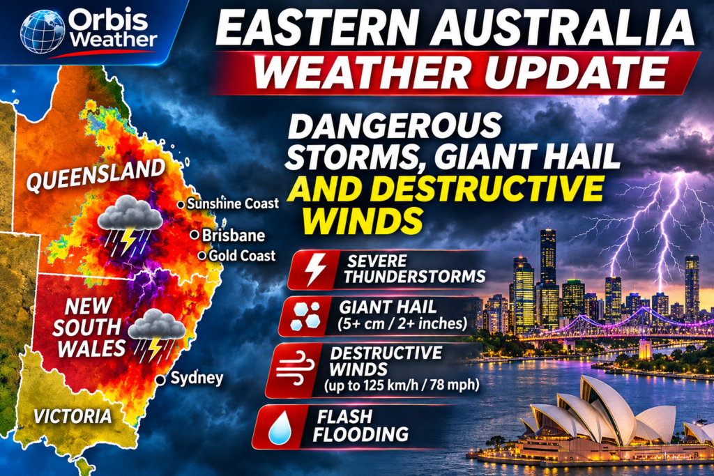
Severe thunderstorms struck eastern Australia for four days running, from a damaging storm near Yass, New South Wales, on Saturday to a broad outbreak on Tuesday. The Bureau of Meteorology (BoM) warned of “very dangerous” storms from Rockhampton to Sydney on Tuesday, November 3. It cited giant hail “well over 5 cm” (2 in) and destructive winds over 125 km/h (78 mph). The worst hail so far fell on Monday, when BoM reported stones of 6 to 10 cm (2.4 to 3.9 in) at Glenwood in Queensland’s Wide Bay region.
The threat now shifts. On Wednesday, BoM expects severe storms in Wide Bay, Capricornia and central Queensland and in western Victoria, while south-east Queensland turns hot and dry. This update is current to 1:20 a.m. AEST (2:20 a.m. AEDT) on Wednesday, November 4, 2026, which is 15:20 UTC on November 3.
The Bureau of Meteorology and state emergency services issue the official warnings. Follow any evacuation order immediately.
Tuesday’s warnings
Tuesday was the peak day, with BoM warning of giant hail and destructive winds across a band of about 2,000 km (1,240 miles). Weatherzone put that band from central Queensland to eastern Victoria (Weatherzone, Nov 3). BoM said the worst risk was north of about Port Macquarie, covering north-east NSW and much of south-east Queensland (BoM video via National Tribune, Nov 3).
Time issued (Nov 3) | State | Areas | Hazards |
|---|---|---|---|
12:48 p.m. AEDT | NSW | Mid North Coast, Hunter, Central Tablelands, North West Slopes and Plains, Northern Tablelands; towns including Armidale, Tamworth, Inverell and Glen Innes (BoM via Weatherzone) | Severe thunderstorms |
About 2:39 p.m. AEST | Queensland | Central Highlands and Coalfields, Darling Downs and Granite Belt, Capricornia, Wide Bay and Burnett, Maranoa and Warrego | Giant hail, destructive winds, heavy rain |
4:22 p.m. AEST | Queensland | Storms near and south of Toowoomba, moving east toward Gatton, Laidley and Ipswich (BoM via gcmag) | Severe thunderstorms |
About 4:00 p.m. AEDT | NSW | Northern Rivers, Mid North Coast, Hunter, Metropolitan (Sydney), Illawarra, Tablelands, Slopes and Plains, South Coast | Giant hail, destructive winds, heavy rain |
The 2:39 p.m. and 4:00 p.m. issue times come from the Early Warning Network alert list, which republishes BoM warnings. BoM also flagged flash flooding as a particular concern in south-east Queensland, where catchments were saturated.
What the storms did
The storms brought giant hail, intense rain and roof damage, but no deaths or injuries had been reported by early Wednesday. Full figures for Tuesday afternoon and evening were not yet available.
Date | Place | What happened | Source |
|---|---|---|---|
Tue Nov 3 | Wellcamp Airport, Toowoomba, Qld | Gust of 106 km/h (66 mph) at 4:07 p.m. AEST | BoM via gcmag, Nov 3 |
Tue Nov 3 | New England, NSW | Hail across the tablelands; SES jobs mostly near Tingha, crews on standby in Tamworth | Armidale Express, Nov 3 |
Mon Nov 2 | Glenwood and Yarraman, Qld | Hail of 6 to 10 cm (2.4 to 3.9 in) at Glenwood and 4 cm (1.6 in) near Yarraman | BoM via Yahoo News Australia, Nov 3 |
Mon Nov 2 | Fraser Coast, Qld | Hail up to 10 cm (3.9 in), banked up on a Maryborough road | ABC News, Nov 3 |
Mon Nov 2 | Cooroy, Sunshine Coast, Qld | 54 mm (2.1 in) of rain in 30 minutes to 4:34 p.m. AEST | |
Mon Nov 2 | Sunshine Coast and Gympie, Qld | More than 2,000 homes without power at 9 a.m. Tuesday | ABC Sunshine Coast, Nov 3 |
Mon Nov 2 | Northern Rivers, NSW | 17 requests for SES help after 6 p.m., mostly fallen trees and minor roof damage; Casino and Copmanhurst busiest | ABC NSW North Coast, Nov 3 |
Sun Nov 1 | Millmerran, Darling Downs, Qld | Hail of 5 cm (2 in) around 3:40 p.m. from a supercell | ABC News, Nov 2 |
Sat Oct 31 | Good Hope, near Yass, NSW | Six roofs torn off and 10 more buildings damaged in what the SES called a “tornado-like event”; BoM has not confirmed a tornado | ABC News, Nov 1 |
At Good Hope, a shipping container was moved about 300 m (980 ft), according to the ABC. Hail piled up on a lawn at Bidwill, and a Hervey Bay resident told the ABC his lawn was “covered with golf balls”.
The forecast
The storms move north and south on Wednesday, then a calmer spell follows before storm chances return on Saturday, November 7. BoM said the trough behind Tuesday’s outbreak would move over the Tasman Sea overnight, with warm westerly winds crossing south-east Queensland (BoM video via National Tribune, Nov 3). A cold front then crosses the south-east states (BoM video via National Tribune, Nov 3).
Region | Wednesday, Nov 4 | Thursday to Saturday |
|---|---|---|
South-east Queensland | Warm, dry and sunny; Brisbane 33°C (91°F) | Storms clear and conditions turn “much more settled”; Brisbane 35°C (95°F) Thursday (ABC); Toowoomba storm possible Saturday (BoM) |
Wide Bay, Capricornia, central Qld | Severe storms possible: damaging winds, large hail, heavy rain | Clearing Thursday |
Western and northern Qld | Low 40s °C (about 104°F); severe heatwave warning for Cape York and Gulf Country | Heat continues |
Eastern NSW and Sydney | Storms move offshore early; Sydney 25°C (77°F), possible late shower | Sydney 28°C (82°F) Saturday with an 80% chance of rain and a chance of a thunderstorm (BoM) |
Canberra | 24°C (75°F), storms in the evening | Not stated |
Victoria | Windy cold front; showers and storms reach Melbourne early afternoon; severe storms possible in the Wimmera around Horsham; snow above about 1,400 m (4,600 ft) | Not stated |
Staying safe
Call the SES on 132 500 for storm or flood help, and Triple Zero (000) if a life is in danger. The steps below come from BoM warning text and SES advice published this week.
- Move cars under cover and away from trees.
- Stay indoors in a strong building during a storm, and keep asthma medication close.
- Never drive, walk or ride through floodwater, and stay away from drains and fallen powerlines.
- Keep phones charged and follow BoM warnings and radar on its website or app.
- In Queensland, the SES Assistance QLD app can also be used to request help.
Frequently asked questions
What counts as giant hail? BoM’s warnings this week linked giant hail to stones “well over 5 cm” (2 in). Monday’s 6 to 10 cm stones at Glenwood were well above that mark.
Was there a tornado near Yass? Not confirmed. The NSW SES described Saturday’s storm at Good Hope as a “tornado-like event”, but BoM had not confirmed a tornado when the ABC reported it on November 1.
Will Brisbane get more storms this week? Not in the next few days. BoM expects hot, dry and sunny weather from Wednesday, with Brisbane near 33 to 35°C (91 to 95°F), and storm chances returning around Saturday.
Is Sydney still at risk? Wednesday’s storms are expected to move offshore early, leaving Sydney mostly dry. BoM gives Sydney an 80% chance of rain on Saturday, with a chance of a thunderstorm.
Why were the storms so widespread? BoM linked Tuesday’s outbreak to a trough over southern inland Queensland, and Weatherzone pointed to an upper-level trough. ABC meteorologist Jonathon How described the atmosphere as “highly unstable” from the NSW South Coast to the Fraser Coast.
Sources
- ABC News: Qld storm supercells after overnight hail dump, Nov 3, 2026, 8:43 a.m. AEST
- ABC News: Queensland storm and hail warning, Nov 2, 2026, 10:12 p.m.
- ABC News: Queensland storms and heatwave, Nov 2, 2026
- ABC News: violent storm near Yass, Nov 1, 2026
- ABC Sunshine Coast briefing, Nov 3, 2026
- ABC NSW North Coast briefing, Nov 3, 2026, 7:08 a.m. AEDT
- Weatherzone: severe thunderstorms Tuesday, Nov 3, 2026
- BoM NSW warning via Weatherzone, 12:48 p.m. AEDT Nov 3, 2026
- BoM Queensland warning via Weatherzone, Nov 2, 2026
- BoM Southeast Queensland warning via gcmag, 4:22 p.m. AEST Nov 3, 2026
- BoM severe weather update via National Tribune, Nov 3, 2026
- BoM national forecast via National Tribune, Nov 3, 2026
- BoM Toowoomba forecast, 3:25 a.m. AEST Nov 3, 2026
- BoM North Sydney forecast, 11:24 a.m. AEDT Nov 3, 2026
- Early Warning Network alerts, Nov 3, 2026
- Yahoo News Australia: supercell warning, Nov 3, 2026
- Armidale Express: New England SES on standby, Nov 3, 2026, 4:16 p.m. AEDT
About the Author
Paul Harrison — Founder & Publisher, Orbis Weather
Paul Harrison founded Orbis Weather in 2026 to make global weather and natural-hazard information easier to find, follow and understand. His coverage includes tropical cyclones, severe weather, extreme temperatures, earthquakes, volcanoes, wildfires, flooding and significant natural disasters worldwide.
View all articles by Paul Harrison → | Editorial Standards →
Global Weather Tracker Hub
Explore weather maps, tropical systems, storms and natural hazards around the world.
No matching trackers found.