Historic Snow Map Shows Which States El Niño Could Hit Hardest This Winter

❄️ Historic Snow Map Shows Which States El Niño Could Hit Hardest This Winter
NOAA says El Niño is rapidly strengthening — and history suggests parts of the West and Mid-Atlantic could face a much stormier winter
A potentially historic El Niño is rapidly developing in the tropical Pacific, raising questions about what the powerful climate pattern could mean for snowfall across the United States during the winter of 2026–27.
The numbers have changed dramatically in just a month.
In July, NOAA’s Climate Prediction Center put the probability of a very strong El Niño at 81% for October through December. By its August 13 update, forecasters said there was now a greater than 90% chance of a very strong event during the Northern Hemisphere fall and winter. Even more remarkable, NOAA assigned a 69% chance that the October–December period could reach a level exceeding previous El Niño events in records dating to 1950. (cpc.ncep.noaa.gov)
That does not guarantee a record-breaking winter — or record snowfall — but historical snowfall maps provide some clues about which parts of the country could have the greatest potential for an unusually active season.
🌊 What Is Happening in the Pacific?
El Niño occurs when ocean temperatures across the central and eastern equatorial Pacific become significantly warmer than normal. Those warm waters can alter atmospheric circulation thousands of miles away, including the position and strength of the jet stream over North America.
NOAA reported this month that El Niño has continued to strengthen, with sea-surface temperature anomalies exceeding 2°C (3.6°F) in portions of the eastern equatorial Pacific. NOAA says the coupled ocean-atmosphere system is now clearly displaying a strengthening El Niño pattern. (cpc.ncep.noaa.gov)
The significance for the United States becomes much greater during winter, when El Niño’s influence on the jet stream is typically strongest.
🌨️ Historic Snow Maps Reveal a North-South Divide
NOAA’s historical analysis of El Niño winters shows a striking pattern.
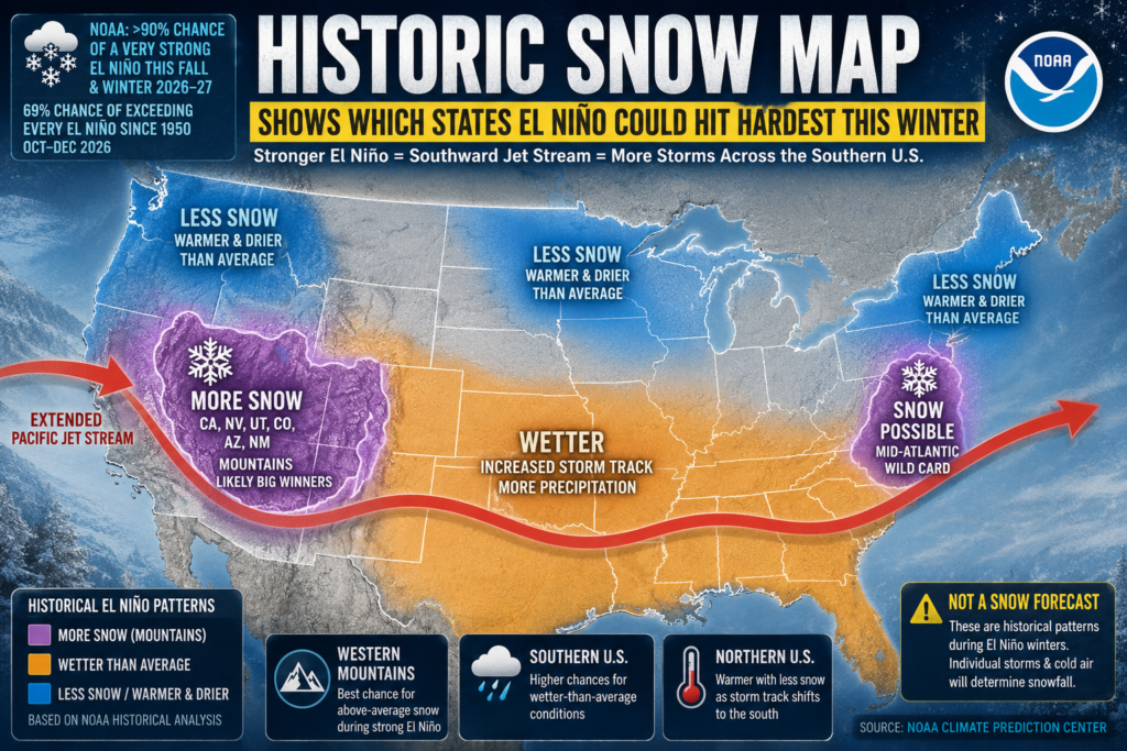
During stronger El Niño events, the Pacific jet stream tends to extend farther east and shift south, steering more storms across the southern half of the United States.
That often produces a broad corridor of increased precipitation from California and the Southwest toward the Southeast and East Coast.
But precipitation does not automatically mean snow.
Temperatures must be cold enough, which is why the strongest historical snowfall signal appears across the mountains and higher elevations of the western United States. (climate.gov)
❄️ Western States Could Be the Big Snow Winners
Historical NOAA snowfall composites highlight several western states where moderate-to-strong El Niño winters have produced above-average snowfall, particularly:
California
Nevada
Arizona
New Mexico
Utah
Colorado
The Sierra Nevada and the mountainous regions of Arizona and New Mexico have historically shown particularly strong increases because the enhanced southern storm track can deliver substantial Pacific moisture while elevations remain cold enough for snow. (climate.gov)
California and Nevada may be especially interesting this winter. Federal drought officials noted Tuesday that two of the three strongest El Niño events since 1950 — 1982–83 and 1997–98 — produced extremely wet conditions across California and Nevada. However, the powerful 2015–16 event produced closer to normal precipitation, demonstrating just how differently individual El Niño winters can unfold. (drought.gov)
🏔️ Southwest Could See More Mountain Snow
Arizona and New Mexico are another area worth watching.
The stronger southern storm track associated with El Niño can bring frequent Pacific storms into the Southwest. At lower elevations, much of that precipitation may fall as rain, but higher elevations can receive significant snowfall.
Utah and Colorado can also benefit when storms penetrate far enough inland.
The result could be periods of substantial mountain snowfall even while temperatures across other parts of the country run above normal.
❄️ Mid-Atlantic Could Be a Wild Card
Another intriguing historical signal appears farther east.
Parts of the Mid-Atlantic — including Virginia and surrounding areas — have experienced increased snowfall during some moderate-to-strong El Niño winters. (climate.gov)
An active southern storm track can send moisture-rich systems toward the East Coast. If sufficiently cold Canadian air is in place when those storms arrive, the setup can produce major snowstorms.
But that is a big “if.”
NOAA’s seasonal temperature outlook favors warmer conditions across portions of the eastern United States, meaning individual storms will depend heavily on the exact positioning of cold air.
A warmer-than-average winter can still produce a blockbuster snowstorm — it may simply have fewer opportunities to do so.
🌡️ Northern U.S. May See Less Snow
The opposite signal appears across much of the northern United States.
Historically, El Niño tends to favor warmer conditions across Canada and the northern tier, while the primary Pacific storm track shifts south.
NOAA snowfall analysis shows decreased snowfall during El Niño winters across areas including the:
Pacific Northwest • Northern Rockies • Upper Midwest • Great Lakes • Interior Northeast
Alaska and western Canada also tend to experience reduced snowfall.
In some areas, the biggest reason isn’t necessarily a dramatic lack of precipitation. Warmer temperatures can simply mean more precipitation falls as rain instead of snow. (climate.gov)
🌧️ Southern U.S. Could Have a Wetter Winter
Snow isn’t the only concern.
El Niño historically increases the chances of a wetter-than-normal winter across much of the southern United States.
NOAA’s long-range outlook increasingly reflects that classic El Niño pattern, with above-normal precipitation favored across portions of the southern tier as winter approaches, while below-normal precipitation becomes more likely across portions of the Northwest, northern Plains and Great Lakes. (cpc.ncep.noaa.gov)
That could translate into a more active winter storm season across parts of California, the Southwest, Gulf Coast and Southeast — even where temperatures are too warm for snow.
⚠️ Important: This Is Not a Snowfall Forecast
This distinction is critical.
NOAA does not issue seasonal snowfall forecasts months in advance, and a historical El Niño snowfall map should not be interpreted as a prediction of exactly where snow will fall this winter.
The maps show what has happened on average during previous El Niño winters.
Individual El Niño events can behave very differently.
NOAA specifically cautions that the strength of El Niño does not necessarily determine the strength of its impacts. Even an exceptionally strong El Niño cannot guarantee that any particular region will experience heavy snow, flooding or unusually warm temperatures. (cpc.ncep.noaa.gov)
🔴 Why Winter 2026–27 Is Getting So Much Attention
What makes this year unusual is the speed and magnitude of the strengthening signal.
NOAA’s August outlook now gives greater than 90% odds of a very strong El Niño during fall and winter, while the October–December period carries a 69% probability of reaching a historic category beyond previous events in the record extending back to 1950. (cpc.ncep.noaa.gov)
If El Niño reaches anything close to those projections, its influence on the North American jet stream could become one of the dominant forces shaping the upcoming winter.
For snow lovers, the historical pattern points toward the mountain West and portions of the southern half of the country as the most interesting areas to watch, while much of the northern tier could face a warmer and potentially less snowy season.
But the atmosphere will ultimately decide whether history repeats itself.
❄️ Bottom Line
Most favorable historical El Niño snow signal: California’s mountains, Nevada, Utah, Arizona, New Mexico and Colorado.
Interesting secondary area: Parts of the Mid-Atlantic, where an active southern storm track combined with occasional cold air can create significant snowstorms.
Lower historical snowfall signal: Pacific Northwest, northern Rockies, northern Plains, Great Lakes and portions of the Northeast.
With El Niño strengthening rapidly, the 2026–27 winter is shaping up to be one of the most closely watched U.S. winter seasons in years.
NOAA Climate Prediction Center — Latest El Niño Discussion



Live Lightning Map
Live U.S. Wildfire Tracker

Live Wildfire Smoke & Air Quality Tracker

Live Earthquake Map