




Trudy’s Tropical Moisture Threatens Flash Flooding From California to Colorado This Week
Orbis Weather | October 20, 2026 | By Paul Harrison
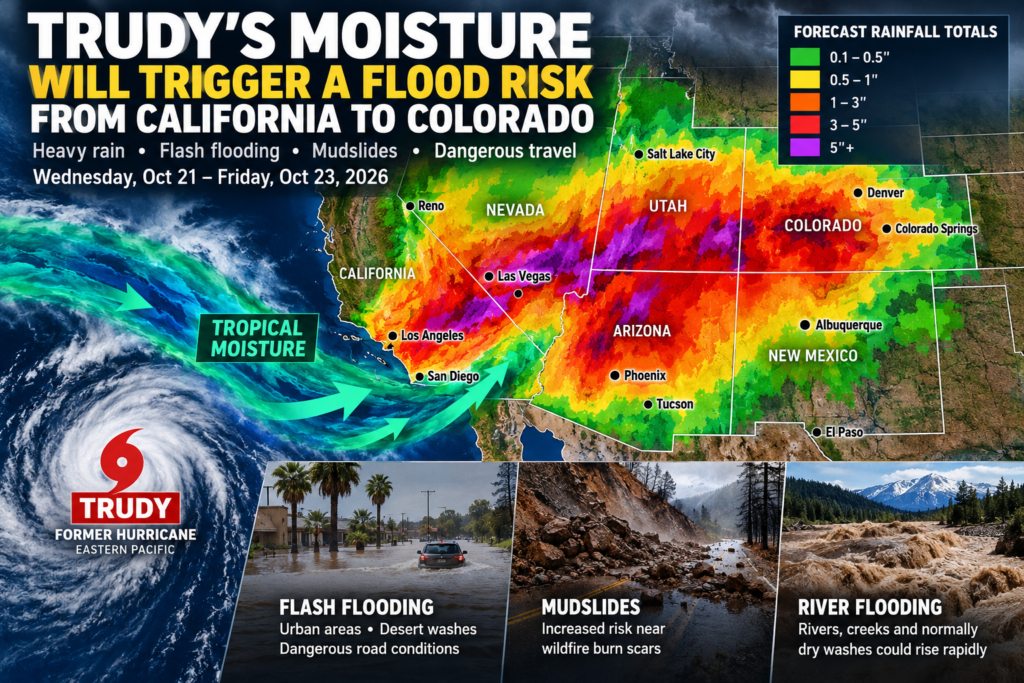
A powerful surge of tropical moisture associated with former Hurricane Trudy is expected to fuel heavy rainfall, dangerous flash flooding and possible mudslides across the southwestern United States from Wednesday through Friday.
A developing storm system will pull moisture northward from the eastern Pacific, creating a widespread flood threat across California, Arizona, Nevada, Utah, New Mexico and Colorado.
The National Weather Service’s Weather Prediction Center has highlighted a Slight Risk of excessive rainfall for portions of the Southwest and Four Corners region on Wednesday, October 21, with particular concern for communities near wildfire burn scars, desert washes and steep mountain terrain.
When will the heaviest rain arrive?
Tuesday, October 20: A Pacific low-pressure system approaches California, bringing increasing clouds and the possibility of rain and mountain precipitation beginning Tuesday night.
Wednesday, October 21: Heavy showers and thunderstorms spread across the Desert Southwest and Four Corners region. Some thunderstorms could repeatedly move across the same locations, producing dangerous rainfall accumulations.
Thursday, October 22: The flooding threat continues across Arizona, New Mexico, Nevada, Utah and Colorado. Additional rainfall over already saturated ground could increase runoff into rivers and normally dry washes.
Friday, October 23: Showers may continue across parts of the Rockies, with elevated river levels and lingering flooding concerns in vulnerable watersheds.
How much rain could fall?
Widespread regional potential
1–3″
25–76 mmIsolated higher totals
5″
Up to 127 mmIntense storm rates
2″/hr
Up to 51 mm/hrWhy Trudy’s moisture is particularly dangerous
Although Trudy has weakened substantially since threatening Mexico’s Pacific coastline, its tropical moisture remains a significant weather hazard.
An upper-level low-pressure system moving into the western United States is expected to draw this moisture inland, producing unusually humid atmospheric conditions for October.
The Weather Prediction Center reports that atmospheric moisture could reach three to four standard deviations above typical mid-October values in parts of the Southwest.
This combination creates conditions favorable for thunderstorms capable of producing intense rainfall over short periods.
California wildfire burn scars face additional danger
Southern California is particularly vulnerable following recent wildfires.
Areas where vegetation has burned away can experience rapid runoff during heavy rainfall. Without established vegetation to stabilize the soil, steep slopes can produce mudslides and debris flows.
Communities near recently burned hillsides should pay close attention to local National Weather Service warnings, particularly if thunderstorms develop over affected watersheds.
Rainfall could provide some relief to ongoing wildfire conditions, but heavy downpours could create a separate and potentially dangerous emergency.
Colorado rivers could rise rapidly
Southwestern Colorado faces a combination of tropical rainfall, unusually high snow levels and potential rain-on-snow runoff.
The National Weather Service office in Grand Junction has warned that rivers, creeks and normally dry washes could rise rapidly Thursday into Friday.
Forecasters have identified possible minor flooding along the San Juan River near Pagosa Springs, with additional concerns involving the Piedra and Animas river basins.
Snow levels could climb above 12,000 feet (3,658 meters), allowing rain to fall at elevations that would ordinarily experience snow in late October.
Safety recommendations
Residents and travelers across the Southwest should take precautions:
Avoid driving through flooded roadways, even when water appears shallow.
Stay out of slot canyons, dry washes and narrow desert valleys when heavy rain is forecast.
Monitor local flood watches and warnings, particularly near recent wildfire burn scars.
Prepare for rapidly changing road conditions in mountainous areas.
Check official forecasts before hiking, camping or visiting national parks.
Orbis Weather analysis
The greatest concern is not a direct strike from Trudy itself, but the interaction between its remaining tropical moisture and a larger Pacific storm system.
The resulting rainfall could affect locations hundreds of miles from Trudy’s former circulation.
While the precipitation may benefit drought-affected areas, intense rainfall over dry desert terrain, burned hillsides and saturated mountain watersheds could produce dangerous flooding.
The most critical period currently appears to be Wednesday, October 21, through Thursday, October 22, although some flooding impacts could persist into Friday.