
Most Disaster-Prone Places on Earth: Global Danger Zones
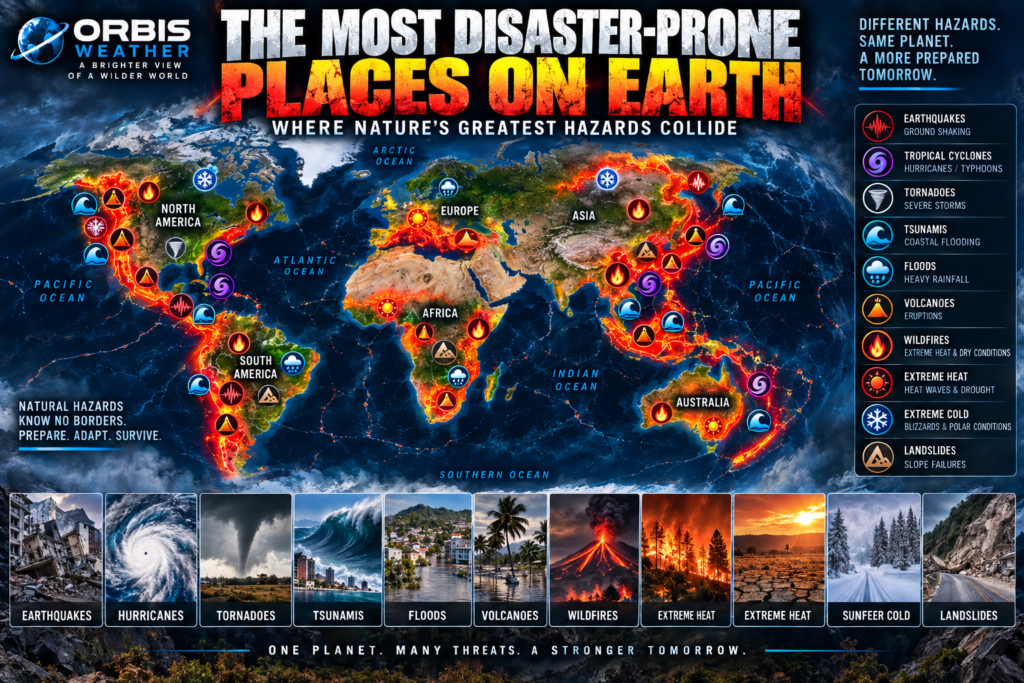
🌎 The Most Disaster-Prone Places on Earth: Where Nature’s Greatest Hazards Collide
Some places face hurricanes.
Others face earthquakes.
Some live beneath volcanoes.
Others endure floods, wildfires, extreme heat, blizzards, tornadoes or landslides.
And then there are places where several of Earth’s greatest natural hazards collide.
A powerful earthquake can trigger a tsunami.
A volcanic eruption can produce lahars.
A tropical cyclone can trigger catastrophic flooding and thousands of landslides.
Wildfire can leave mountains vulnerable to debris flows when the rain returns.
Extreme heat can intensify drought and wildfire conditions.
One disaster can create another.
These are Earth’s multi-hazard zones — places where geology, weather, climate, oceans and human settlement overlap in ways that can create extraordinary natural-disaster risk.
But there is an important distinction.
A place isn’t automatically dangerous simply because many hazards occur there.
The United Nations Office for Disaster Risk Reduction describes disaster risk as the interaction between hazards, exposure, vulnerability and the capacity to cope with them.
A powerful earthquake in an uninhabited desert is very different from the same earthquake beneath a city of ten million people.
A Category 5 tropical cyclone passing over open ocean is very different from one approaching a densely populated coastline.
Natural hazards become disasters when they collide with people and infrastructure.
And across several regions of Earth, those collisions happen again and again.
🌏 Asia — Where Many of Earth’s Hazards Converge
If one continent demonstrates multi-hazard exposure better than any other, it is Asia.
The World Meteorological Organization has repeatedly identified Asia as the world’s most disaster-affected region from weather, climate and water-related hazards.
In 2025, Asia experienced dangerous heat, devastating floods, severe drought, tropical cyclone rainfall, glacier retreat and major economic and human impacts.
But weather represents only part of the story.
Asia also contains some of Earth’s most active tectonic boundaries.
The Pacific Ring of Fire runs along its eastern edge.
The Himalayas rise where continental plates collide.
The western Pacific generates the world’s greatest concentration of tropical cyclones.
Enormous river deltas cross low-lying landscapes.
Billions of people live within this environment.
Few places demonstrate the result better than the Philippines, Indonesia and Japan.
🇵🇭 Philippines — Typhoons, Earthquakes, Volcanoes and Landslides
The Philippines sits almost exactly where several of Earth’s major natural-hazard systems meet.
To the east lies the enormous western Pacific Ocean.
It is the most active tropical cyclone basin on Earth.
Typhoons regularly approach the Philippine islands carrying:
🌀 Destructive winds
🌊 Storm surge
🌧️ Torrential rainfall
🌊 Flooding
⛰️ Landslides
But underneath the Philippines is another danger.
The country lies along the Pacific Ring of Fire.
Active faults and offshore trenches create earthquake risk.
Subduction zones create tsunami potential.
Volcanoes rise across the islands.
The Philippines therefore faces an extraordinary combination:
🌀 Typhoons
🌎 Earthquakes
🌋 Volcanoes
🌊 Tsunamis
🌧️ Floods
⛰️ Landslides
🥵 Extreme heat
One tropical cyclone can already produce several hazards simultaneously.
Add the geological hazards beneath the islands and the Philippines becomes one of Earth’s clearest examples of a multi-hazard environment.
🇮🇩 Indonesia — Where the Ring of Fire Meets the Tropics
Indonesia may be one of the most geologically complicated countries on Earth.
Thousands of islands stretch across an enormous region where several tectonic plates interact.
The result is extraordinary volcanic and seismic activity.
Indonesia contains more than 100 volcanoes with evidence of activity during the Holocene.
Powerful earthquakes occur along enormous subduction zones.
Those earthquakes can generate tsunamis.
The 2004 magnitude 9.1 Sumatra-Andaman earthquake produced a catastrophic Indian Ocean tsunami that demonstrated the global reach of Indonesia’s tectonic hazards.
But Indonesia is also tropical.
Intense rainfall can produce:
🌊 Flooding
⛰️ Landslides
🌋 Volcanic debris flows
Urban development adds additional exposure.
Indonesia’s major hazards include:
🌎 Earthquakes
🌋 Volcanoes
🌊 Tsunamis
🌧️ Flooding
⛰️ Landslides
🔥 Wildfires and peat fires
🥵 Extreme heat
Few countries sit at the intersection of so many geological and meteorological systems.
🇯🇵 Japan — Engineering Against a Restless Planet
Japan is another extraordinary multi-hazard country.
Offshore, enormous tectonic plates meet along major subduction zones.
That creates frequent earthquakes.
Some can become megathrust earthquakes capable of generating tsunamis.
Japan also contains numerous active volcanoes.
Then there is the atmosphere.
Typhoons approach from the western Pacific, bringing extreme rainfall, damaging winds, storm surge and landslides.
Winter adds another hazard.
Cold air crossing the Sea of Japan can produce enormous snowfall along portions of the country.
Japan therefore experiences:
🌎 Earthquakes
🌊 Tsunamis
🌋 Volcanoes
🌀 Typhoons
🌧️ Flooding
⛰️ Landslides
❄️ Extreme snow
🥵 Extreme heat
Yet Japan also demonstrates something equally important:
Hazard does not automatically equal catastrophe.
Earthquake-resistant engineering, tsunami defenses, monitoring networks, warning systems, evacuation planning and public education can substantially reduce disaster risk.
🇳🇵 Nepal — Where the Mountains Themselves Are a Hazard
Nepal sits within one of Earth’s most dramatic geological environments.
The Indian Plate continues pushing into Eurasia.
That collision created the Himalayas.
It also produces earthquakes.
Then every year, monsoon moisture reaches the mountains.
Heavy rain falls across extremely steep terrain.
Slopes fail.
Landslides block roads.
Rivers flood.
Mountain communities become isolated.
Glacial lakes high in the Himalayas create another danger.
If natural dams containing these lakes fail, enormous quantities of water can rush downstream.
Nepal’s major hazards therefore include:
🌎 Earthquakes
⛰️ Landslides
🌊 River flooding
🌧️ Monsoon rainfall
🏔️ Glacial lake outburst floods
❄️ Avalanches
🥵 Increasing extreme heat
The Himalayas demonstrate how geology and weather can combine to create cascading disasters.
🇧🇩 Bangladesh — Water From Every Direction
Bangladesh faces a very different collection of hazards.
Much of the country occupies the enormous Ganges-Brahmaputra-Meghna Delta.
Some of Asia’s greatest rivers converge here before reaching the Bay of Bengal.
Monsoon rainfall raises river levels.
Rain falling far upstream can eventually reach Bangladesh.
Tropical cyclones approach from the Bay of Bengal.
Storm surge pushes seawater inland.
Extreme rainfall overwhelms drainage.
The result is one of Earth’s great flood environments.
Bangladesh faces:
🌊 River flooding
🌀 Tropical cyclones
🌊 Storm surge
🌧️ Extreme rainfall
🥵 Extreme heat
⚡ Severe thunderstorms
🌊 Coastal flooding
Population density dramatically increases exposure.
Bangladesh demonstrates why disaster risk is about more than the physical hazard.
Millions of people may live within the same floodplain.
🇹🇼 Taiwan — Typhoons Meet Earthquakes and Mountains
Taiwan sits between major geological and meteorological systems.
The island lies within an active tectonic zone.
Earthquakes are common.
Its mountains rise dramatically from the surrounding ocean.
Then typhoons arrive.
A tropical cyclone can push tremendous amounts of moisture against Taiwan’s mountains.
Rainfall intensifies.
Rivers rise rapidly.
Slopes collapse.
One storm can therefore produce:
🌀 Typhoon winds
🌧️ Extreme rainfall
🌊 Flash flooding
⛰️ Landslides
🌊 Coastal flooding
At the same time, Taiwan faces significant earthquake risk.
This is a classic multi-hazard landscape.
🇺🇸 United States — Almost Every Major Hazard
Few large countries experience as many different categories of natural hazards as the United States.
Consider the geography.
The Atlantic and Gulf of Mexico produce hurricane exposure.
The Great Plains produce severe thunderstorms and tornadoes.
The West experiences earthquakes and wildfires.
Alaska lies along the Ring of Fire.
Hawaii contains active volcanoes.
The Pacific Northwest contains the Cascadia Subduction Zone.
Mountain states experience avalanches and extreme winter weather.
Deserts experience dangerous heat.
Major rivers flood.
The United States faces:
🌀 Hurricanes
🌪️ Tornadoes
🌊 Flooding
⚡ Severe thunderstorms
🔥 Wildfires
🌎 Earthquakes
🌋 Volcanoes
🌊 Tsunamis
🥵 Extreme heat
❄️ Extreme cold
⛰️ Landslides
Few countries contain such a broad spectrum of natural hazards.
🌴 Florida — Hurricanes, Floods, Lightning and Heat
Florida represents one of America’s most distinctive multi-hazard environments.
The state is surrounded by warm water.
Hurricanes can approach from the Atlantic, Caribbean or Gulf of Mexico.
Low-lying coastlines create storm-surge exposure.
Extreme rainfall can produce flooding.
Florida also experiences extraordinary thunderstorm and lightning activity.
Extreme heat and humidity add another weather hazard.
Florida’s major natural hazards include:
🌀 Hurricanes
🌊 Storm surge
🌧️ Flooding
⚡ Lightning
🌪️ Tornadoes
🥵 Extreme heat
🔥 Wildfire
The state lacks the major earthquake and volcanic hazards found along the Pacific coast, but its exposure to tropical and coastal hazards is substantial.
🇺🇸 California — Earthquakes, Wildfires, Floods and Landslides
California represents another type of American multi-hazard zone.
The San Andreas Fault system creates earthquake risk.
Mountain and coastal terrain creates landslide exposure.
Hot, dry conditions can create extreme wildfire environments.
Atmospheric rivers can deliver enormous rainfall.
Heavy rain over wildfire burn scars can trigger debris flows.
California can therefore experience:
🌎 Earthquakes
🔥 Wildfires
🌧️ Flooding
⛰️ Landslides
🌊 Tsunamis
🥵 Extreme heat
❄️ Mountain snowstorms
🌵 Drought
One hazard can even prepare the landscape for another.
Wildfire → burned slope → extreme rain → debris flow.
That is cascading risk.
🇺🇸 Alaska — Earthquakes, Volcanoes, Tsunamis and Extreme Cold
Alaska combines some of America’s greatest geological hazards.
The Alaska-Aleutian subduction zone produces powerful earthquakes.
The state contains numerous volcanoes.
Large earthquakes can generate tsunamis.
Mountain terrain creates landslides and avalanches.
Then there is the climate.
Extreme winter cold, snowstorms and ice create additional hazards.
Alaska experiences:
🌎 Earthquakes
🌋 Volcanoes
🌊 Tsunamis
⛰️ Landslides
❄️ Extreme cold
❄️ Avalanches
🔥 Wildfires
🌊 Coastal storms
The 1964 magnitude 9.2 Alaska earthquake remains the largest earthquake recorded in U.S. history.
🇲🇽 Mexico — Between Hurricanes and the Ring of Fire
Mexico sits between two enormous hazard systems.
To the west, tectonic plates converge along the Pacific coast.
Earthquakes and volcanoes result.
To the east lie the Gulf of Mexico and Caribbean.
Hurricanes arrive from both the Atlantic and eastern Pacific sides of the country.
Mountainous terrain increases landslide risk.
Extreme heat and drought affect other regions.
Mexico therefore faces:
🌎 Earthquakes
🌋 Volcanoes
🌀 Hurricanes
🌊 Flooding
⛰️ Landslides
🥵 Extreme heat
🌵 Drought
🔥 Wildfire
Few countries have major tropical cyclone exposure on two different ocean basins.
🌎 Central America — A Narrow Corridor of Hazards
Central America sits between the Pacific and Caribbean.
That narrow geography produces extraordinary hazard exposure.
Pacific subduction creates earthquakes and volcanoes.
The Caribbean and eastern Pacific produce tropical cyclones.
Steep volcanic mountains amplify rainfall.
Floods and landslides follow.
Countries including Guatemala, El Salvador, Honduras, Nicaragua and Costa Rica can experience:
🌎 Earthquakes
🌋 Volcanoes
🌀 Tropical cyclones
🌊 Flooding
⛰️ Landslides
🌊 Tsunamis
🥵 Extreme heat
The region is essentially a collision zone between tropical weather and active geology.
🇨🇱 Chile — Earthquakes Beneath a Land of Extremes
Chile stretches thousands of miles along the western edge of South America.
Offshore, the Nazca Plate descends beneath the South American Plate.
This creates enormous earthquakes and a long chain of volcanoes.
The 1960 magnitude 9.5 Chile earthquake remains the largest instrumentally recorded earthquake in history.
It generated a Pacific-wide tsunami.
Chile also experiences:
🌎 Earthquakes
🌋 Volcanoes
🌊 Tsunamis
⛰️ Landslides
🔥 Wildfires
🌊 Flooding
🌵 Drought
🥵 Extreme heat
❄️ Mountain snow and avalanches
Its extraordinary north-to-south geography exposes the country to environments ranging from the Atacama Desert to glaciers and subpolar conditions.
🇮🇹 Italy — Europe’s Geological Hotspot
Europe generally experiences fewer tropical hazards than Southeast Asia or the Caribbean.
But Italy stands out geologically.
The country contains famous volcanoes including:
🌋 Etna
🌋 Stromboli
🌋 Vesuvius
Earthquakes occur throughout portions of the country.
Steep terrain creates landslide exposure.
Heavy rainfall can produce flash flooding.
Mediterranean heatwaves and drought can contribute to wildfire conditions.
Italy’s hazards include:
🌎 Earthquakes
🌋 Volcanoes
🌊 Tsunamis
🌊 Flash floods
⛰️ Landslides
🔥 Wildfires
🥵 Extreme heat
Italy demonstrates that serious multi-hazard environments also exist within Europe.
🇬🇷 Greece and the Eastern Mediterranean
Greece and the surrounding eastern Mediterranean form another European hazard zone.
The region experiences earthquakes because of active tectonic boundaries.
Historical tsunamis have occurred.
Summer heat and drought create wildfire conditions.
Intense rainfall can cause flash flooding.
Steep terrain can generate landslides.
The region combines:
🌎 Earthquakes
🌊 Tsunamis
🔥 Wildfires
🥵 Extreme heat
🌊 Flash flooding
⛰️ Landslides
Natural hazards do not stop at the boundaries of the Pacific Ring of Fire.
🇦🇺 Australia — Fire, Heat, Flood and Cyclone Country
Australia has relatively low exposure to major tectonic disasters compared with Indonesia or Japan.
But meteorological hazards can be extreme.
Northern Australia experiences tropical cyclones.
The interior experiences extraordinary heat.
Large areas experience drought.
Bushfires can become enormous.
Other regions experience extreme rainfall and flooding.
Severe thunderstorms can produce giant hail and damaging winds.
Australia’s major hazards include:
🔥 Bushfires
🥵 Extreme heat
🌵 Drought
🌀 Tropical cyclones
🌊 Flooding
⚡ Severe thunderstorms
The 2019–2020 Black Summer demonstrated how extreme heat, drought and fire can combine into a national-scale disaster.
🌍 East Africa — Drought, Floods, Heat and Volcanoes
East Africa faces another unusual combination of hazards.
The East African Rift produces earthquakes and volcanoes.
At the same time, weather extremes can swing between severe drought and destructive flooding.
Extreme heat adds additional stress.
Some regions experience:
🌋 Volcanoes
🌎 Earthquakes
🌵 Drought
🌊 Flooding
⛰️ Landslides
🥵 Extreme heat
The region demonstrates how geological and climate-related hazards can overlap even far from the Ring of Fire.
🌀 When One Disaster Creates Another
The most dangerous natural disasters are sometimes not individual events.
They are chains of events.
Consider these possibilities:
🌎 Earthquake → 🌊 Tsunami
🌎 Earthquake → ⛰️ Landslide → 🌊 Landslide-dam flood
🌋 Volcano → 🧊 Snowmelt → 🌊 Lahar
🌀 Hurricane → 🌧️ Extreme rain → 🌊 Flood → ⛰️ Landslides
🔥 Wildfire → 🌧️ Heavy rain → ⛰️ Debris flow
🥵 Heatwave → 🌵 Drought → 🔥 Wildfire
❄️ Extreme snowfall → 🌨️ Avalanche
This is known as cascading or compound risk.
UNDRR’s multi-hazard framework explicitly recognizes that hazards may occur simultaneously, sequentially or cumulatively and may interact with one another.
Understanding those relationships is increasingly important.
🌎 Hazard Is Not the Same as Disaster Risk
This distinction matters.
Imagine two identical earthquakes.
One occurs beneath an uninhabited desert.
The other occurs beneath a densely populated city with vulnerable buildings.
The physical hazard may be similar.
The disaster is not.
UNDRR describes disaster risk as a function of factors including:
⚠️ Hazard
👥 Exposure
🏚️ Vulnerability
🛡️ Capacity
That means preparedness matters.
Building codes matter.
Warning systems matter.
Evacuation routes matter.
Education matters.
Infrastructure matters.
A country cannot stop tectonic plates from moving.
It cannot stop hurricanes from forming.
But it can reduce how destructive those hazards become.
🛰️ Technology Is Changing Disaster Preparedness
Humanity has never been better equipped to observe natural hazards.
Satellites watch hurricanes from space.
Seismometers detect earthquakes.
Ocean buoys help detect tsunamis.
Radar tracks severe thunderstorms.
Weather satellites monitor wildfire smoke.
Thermal sensors identify active fires.
GPS instruments detect movement around volcanoes.
River gauges monitor floods.
Computer models forecast extreme weather.
Warnings can reach millions of phones within seconds.
We cannot prevent most natural hazards.
But increasingly, we can see them coming or recognize them faster.
⚠️ Early Warning Saves Lives
A hurricane forecast issued days in advance gives communities time to prepare.
A tsunami warning can send people toward high ground.
A tornado warning can send families into shelters.
A flood forecast can trigger evacuation.
Volcano monitoring can identify increasing unrest.
Earthquake early-warning systems can provide precious seconds before strong shaking reaches locations farther from the epicenter.
WMO’s 2025 assessment of Asia emphasizes that early warnings and coordinated action can reduce disaster impacts.
Technology cannot eliminate risk.
But information can change the outcome.
🌎 Earth’s Great Multi-Hazard Zones
Several regions stand out because multiple major hazards overlap.
🇵🇭 Philippines
🌀 Typhoons
🌎 Earthquakes
🌋 Volcanoes
🌊 Tsunamis
🌧️ Floods
⛰️ Landslides
🥵 Extreme heat
🇮🇩 Indonesia
🌎 Earthquakes
🌋 Volcanoes
🌊 Tsunamis
🌧️ Floods
⛰️ Landslides
🔥 Wildfires and peat fires
🥵 Extreme heat
🇯🇵 Japan
🌎 Earthquakes
🌊 Tsunamis
🌋 Volcanoes
🌀 Typhoons
🌧️ Flooding
⛰️ Landslides
❄️ Extreme snow
🥵 Extreme heat
🇳🇵 Nepal and the Himalayas
🌎 Earthquakes
⛰️ Landslides
🌊 Floods
🏔️ Glacial hazards
❄️ Avalanches
🌧️ Extreme monsoon rainfall
🇺🇸 United States
🌀 Hurricanes
🌪️ Tornadoes
🔥 Wildfires
🌎 Earthquakes
🌋 Volcanoes
🌊 Tsunamis
🌊 Floods
⚡ Severe storms
🥵 Extreme heat
❄️ Extreme cold
⛰️ Landslides
🇲🇽 Mexico and Central America
🌎 Earthquakes
🌋 Volcanoes
🌀 Hurricanes
🌊 Floods
⛰️ Landslides
🌊 Tsunamis
🔥 Wildfires
🥵 Extreme heat
🇨🇱 Andes and Western South America
🌎 Earthquakes
🌋 Volcanoes
🌊 Tsunamis
⛰️ Landslides
🌊 Floods
🔥 Wildfires
🌵 Drought
These aren’t rankings.
Each region has a different combination of hazards, population exposure and resilience.
🌍 So Where Are the Most Disaster-Prone Places on Earth?
There is no scientifically meaningful single “most disaster-prone place on Earth” without first defining what is being measured.
Number of hazards?
Deaths?
Economic losses?
Population exposed?
Frequency?
Probability?
Infrastructure vulnerability?
Ability to recover?
Different measurements produce different answers.
But the global map reveals several unmistakable clusters.
Southeast Asia and the western Pacific combine typhoons with some of Earth’s most active earthquake, volcano and tsunami zones.
The Himalayas and South Asia combine earthquakes, monsoon floods, landslides, extreme heat and glacial hazards.
The Americas combine hurricanes, tornadoes, earthquakes, volcanoes, tsunamis, wildfires, floods and temperature extremes across an enormous range of environments.
The Mediterranean combines earthquakes, volcanoes, tsunamis, wildfire, heat and flash flooding.
And WMO continues to identify Asia as particularly heavily affected by weather, climate and water-related extremes; its 2025 report documents severe heat, flooding, drought and tropical-cyclone rainfall across the region.
One geological pattern also remains impossible to ignore.
Around the Pacific Ring of Fire, approximately 81% of Earth’s largest earthquakes occur, according to the U.S. Geological Survey.
Add the world’s most active tropical cyclone basin, hundreds of volcanoes, tsunami-producing trenches, mountainous terrain and enormous coastal populations, and the western Pacific becomes one of the clearest examples of overlapping natural hazards on Earth.
But the greatest lesson isn’t about identifying the world’s most dangerous country.
It is about understanding risk.
Hazards are natural.
Disasters depend heavily on exposure, vulnerability and preparedness.
Earthquakes will continue.
Volcanoes will erupt.
Hurricanes and typhoons will form.
Rivers will flood.
Wildfires will burn.
Mountains will collapse.
Heatwaves and winter storms will return.
We cannot make Earth stop being Earth.
But we can monitor it.
We can understand it.
We can prepare for it.
And sometimes, knowing what comes next can save thousands of lives.
One planet. Many hazards. A more prepared world.
❓ Most Disaster-Prone Places on Earth — FAQ
What does “disaster-prone” mean?
It generally describes locations repeatedly exposed to significant natural hazards. Actual disaster risk also depends on population exposure, vulnerability, infrastructure and preparedness.
What is a multi-hazard zone?
A multi-hazard zone is an area exposed to several hazards or where hazards can occur simultaneously, sequentially or cumulatively.
Which region experiences the widest overlap of natural hazards?
South, Southeast and East Asia contain an exceptional overlap of tropical cyclones, floods, earthquakes, volcanoes, tsunamis, landslides and extreme heat. WMO has repeatedly documented Asia’s very high exposure to weather, climate and water-related disasters.
Why is the Philippines exposed to so many hazards?
The Philippines lies along the Pacific Ring of Fire while also sitting directly within the western Pacific tropical cyclone region.
Why is Indonesia so disaster-prone?
Indonesia combines major tectonic plate boundaries, numerous volcanoes, earthquake and tsunami sources, tropical rainfall, floods and landslides.
Is the United States disaster-prone?
The United States experiences an unusually broad range of natural hazards because of its size and geography, including hurricanes, tornadoes, floods, earthquakes, wildfires, volcanoes, tsunamis, extreme heat, extreme cold and landslides.
Can one natural disaster trigger another?
Yes. Earthquakes can generate tsunamis and landslides; tropical cyclones can trigger floods and landslides; volcanic eruptions can generate lahars; and heavy rainfall following wildfires can produce debris flows.
Does having many hazards automatically make a country dangerous?
No. Disaster risk depends on exposure, vulnerability and the ability to prepare for and respond to hazards.
Are natural disasters becoming worse?
The answer depends on the hazard and metric. Climate change is increasing or altering several weather- and climate-related hazards, including extreme heat and some heavy-rainfall risks, while population growth and development in exposed locations can also increase losses. Geological hazards such as earthquakes arise from different physical processes.
Can natural disasters be prevented?
Most natural hazards cannot be prevented, but their impacts can often be reduced through monitoring, early warnings, resilient construction, evacuation planning, land-use decisions and public preparedness.
Where can I track global natural hazards?
Follow Orbis Weather for global coverage of earthquakes, tropical cyclones, volcanoes, wildfires, floods, severe weather and other major natural hazards.