
Weekly Global Earthquake Report (M4.5+)

- Europe Weather & Natural Hazards Today – Monday, November 16, 2026 7:14 PM
- Southeast Asia Weather & Natural Hazards Today: Monday, November 16, 2026 7:07 PM
- Singapore Weather & Natural Hazards This Week, November 16, 2026 6:58 PM
- Africa Weather & Natural Hazards Today — Monday, November 16, 2026 5:43 PM
- Middle East Weather & Natural Hazards Today – Monday, November 16, 2026 3:58 PM
- Global Volcano Report — November 8–14, 2026 3:22 PM
- Global Earthquake Report — November 8–14, 2026 (M4.5+) 3:12 PM
- Australia, New Zealand & Oceania Weather & Natural Hazards Today — Monday, November 16, 2026 12:15 PM
- Flooding in Aceh Spurs Warnings as Severe Weather Threatens 9:09 AM
- North America Weather & Natural Hazards Today – November 15, 2026 8:57 AM
- Central America Weather & Natural Hazards Today – Sunday, November 15, 2026 8:49 AM
- South America Weather & Natural Hazards Today – November 15, 2026 8:41 AM
- Weekly Earth Watch: Volcanoes, Earthquakes & Natural Hazards – Week ending November 15, 2026 8:29 AM
- Daily Earthquakes, Storms, Fires & Floods Report November 15, 2026 8:21 AM
- Australian Region Tropical Weather Update: Sunday, November 15, 2026 8:14 AM
- Southwest Indian Ocean Tropical Weather Update: Sunday, November 15, 2026 8:06 AM
- WESTERN PACIFIC Tropical Weather Update – November 15, 2026 7:57 AM





Global Earthquake Report — November 8–14, 2026 (M4.5+)
· @Paul
By Paul Harrison, Orbis Weather
Summary
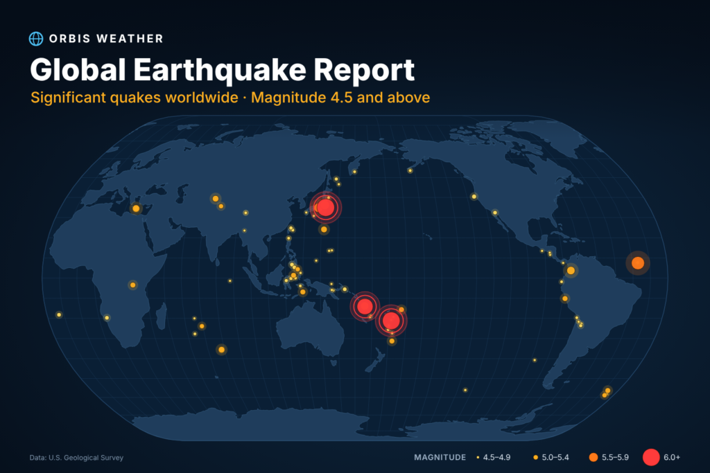
USGS recorded 119 earthquakes of magnitude 4.5 or greater worldwide from 00:00 UTC on November 8 to 00:00 UTC on November 15, 2026. One reached M6 or above, and 31 were M5.0 or greater.
Location (USGS) | Magnitude | Time (UTC) | Depth (km) |
|---|---|---|---|
30 km WSW of Lata, Solomon Islands | Nov 9, 03:34 | 17.0 | |
148 km NW of Kavieng, Papua New Guinea | Nov 12, 22:04 | 10.0 | |
79 km WSW of Changuillo, Peru | Nov 13, 16:43 | 10.0 | |
106 km ENE of Hasaki, Japan | Nov 9, 04:52 | 24.2 |
- Solomon Islands (Lata): 5 events within 65 km of Lata between Nov 9 and Nov 10, led by the week’s largest, the M6.4 on Nov 9. A sixth Solomon Islands event struck east of Kirakira.
- Indonesia: 18 events carried an Indonesia location, more than any other country. Four were east of Masohi (Seram), including an M5.4 on Nov 9, and two near Pulau Pulau Tanimbar reached M5.4 and M5.1.
- Japan: 11 events, mostly off the Pacific coast of Honshu. The largest was the M5.7 east-northeast of Hasaki on Nov 9.
- Papua New Guinea and Fiji: 3 events northwest of Kavieng (M5.8, M5.1, M4.8) on Nov 12–13. Separately, 6 of the 8 Fiji-area events were deeper than 300 km.
PAGER alerts: 9 events received a green alert; none reached yellow, orange or red.
Tsunami flags: 1 event carried a USGS tsunami flag (M4.7, 130 km W of Tofino, Canada, on Nov 11). The flag means the event was in a region where tsunami information is issued, not that a tsunami occurred.
Exactly M4.5: 20 of the 119 events.
Earthquake list
All 119 M4.5+ events, newest first. Each magnitude links to its USGS event page.
Time (UTC) | Magnitude | Location (USGS) | Depth (km) |
|---|---|---|---|
Nov 14, 22:23 | east central Pacific Ocean | 10.0 | |
Nov 14, 21:24 | 25 km N of Ruteng, Indonesia | 10.0 | |
Nov 14, 18:04 | 24 km S of Yacuiba, Bolivia | 506.3 | |
Nov 14, 16:56 | 96 km SSE of Pondaguitan, Philippines | 65.4 | |
Nov 14, 16:36 | 62 km WNW of San Antonio de los Cobres, Argentina | 197.6 | |
Nov 14, 16:04 | 7 km SE of Tagbina, Philippines | 154.1 | |
Nov 14, 13:17 | south of the Kermadec Islands | 12.0 | |
Nov 14, 12:28 | 137 km SE of Petropavlovsk-Kamchatsky, Russia | 17.4 | |
Nov 14, 09:26 | northern Mid-Atlantic Ridge | 10.0 | |
Nov 14, 07:02 | 102 km NNE of Hihifo, Tonga | 10.0 | |
Nov 14, 06:52 | State of Yap, Federated States of Micronesia | 10.0 | |
Nov 14, 06:33 | West Chile Rise | 10.0 | |
Nov 14, 04:59 | western Indian-Antarctic Ridge | 10.0 | |
Nov 14, 03:18 | 54 km NW of San Antonio de los Cobres, Argentina | 216.1 | |
Nov 14, 02:59 | off the west coast of northern Sumatra | 10.0 | |
Nov 14, 02:21 | Fiji region | 587.4 | |
Nov 13, 23:58 | 22 km NE of Kinablangan, Philippines | 10.0 | |
Nov 13, 23:55 | 100 km WSW of Lebu, Chile | 10.0 | |
Nov 13, 23:30 | 153 km NW of Kavieng, Papua New Guinea | 10.0 | |
Nov 13, 23:22 | 74 km S of Yudomari, Japan | 40.9 | |
Nov 13, 22:10 | south of the Kermadec Islands | 36.9 | |
Nov 13, 21:19 | 33 km SSW of La Libertad, El Salvador | 59.1 | |
Nov 13, 19:49 | 153 km NW of Kavieng, Papua New Guinea | 10.0 | |
Nov 13, 19:43 | 9 km WSW of Chaparral, Colombia | 10.0 | |
Nov 13, 19:04 | South Sandwich Islands region | 63.8 | |
Nov 13, 18:55 | south of the Fiji Islands | 563.3 | |
Nov 13, 16:43 | 79 km WSW of Changuillo, Peru | 10.0 | |
Nov 13, 16:35 | 10 km SW of Guaymate, Dominican Republic | 136.7 | |
Nov 13, 16:17 | 79 km NE of Kuqa, China | 10.0 | |
Nov 13, 14:12 | West Chile Rise | 10.0 | |
Nov 13, 11:18 | 59 km WSW of Houma, Tonga | 162.8 | |
Nov 13, 10:55 | 86 km NNE of Lagunas, Peru | 10.0 | |
Nov 13, 09:55 | southeast of the Loyalty Islands | 10.0 | |
Nov 13, 09:40 | 84 km E of Barcelona, Philippines | 10.0 | |
Nov 13, 08:01 | 18 km WNW of Río Grande, Panama | 10.0 | |
Nov 13, 04:49 | 27 km NNE of Labuan Lombok, Indonesia | 9.6 | |
Nov 13, 02:55 | Pagan region, Northern Mariana Islands | 219.6 | |
Nov 13, 02:26 | 278 km E of Levuka, Fiji | 527.1 | |
Nov 13, 01:12 | 85 km W of Mwene-Ditu, Democratic Republic of the Congo | 10.0 | |
Nov 13, 00:05 | 39 km S of Moíres, Greece | 43.4 | |
Nov 12, 22:04 | 148 km NW of Kavieng, Papua New Guinea | 10.0 | |
Nov 12, 21:53 | 117 km S of Akureyri, Iceland | 10.0 | |
Nov 12, 21:15 | western Indian-Antarctic Ridge | 10.0 | |
Nov 12, 21:09 | western Indian-Antarctic Ridge | 10.0 | |
Nov 12, 20:03 | 41 km N of Weining, China | 10.0 | |
Nov 12, 14:58 | 115 km ESE of Bitung, Indonesia | 39.2 | |
Nov 12, 13:27 | 3 km E of Tako, Japan | 73.4 | |
Nov 12, 11:16 | 83 km NE of Ruteng, Indonesia | 10.0 | |
Nov 12, 08:17 | off the coast of Oregon | 10.0 | |
Nov 12, 04:07 | 155 km E of Noda, Japan | 33.0 | |
Nov 12, 03:45 | South Sandwich Islands region | 121.6 | |
Nov 12, 01:18 | 43 km SE of Severo-Kuril’sk, Russia | 74.5 | |
Nov 11, 23:00 | 73 km NNW of Gyalshing, India | 10.0 | |
Nov 11, 22:03 | 116 km E of Georgetown, Saint Helena | 10.0 | |
Nov 11, 20:45 | 41 km SSE of Camiña, Chile | 113.0 | |
Nov 11, 19:50 | south of the Fiji Islands | 527.6 | |
Nov 11, 19:21 | 48 km NW of Ancud, Chile | 18.8 | |
Nov 11, 17:38 | 81 km W of Panguna, Papua New Guinea | 74.4 | |
Nov 11, 15:39 | South Sandwich Islands region | 104.7 | |
Nov 11, 12:45 | 62 km NNE of Port-Olry, Vanuatu | 149.4 | |
Nov 11, 12:17 | 168 km W of Fakfak, Indonesia | 10.0 | |
Nov 11, 12:10 | 130 km E of Masohi, Indonesia | 10.0 | |
Nov 11, 11:36 | 27 km WSW of Calama, Chile | 91.3 | |
Nov 11, 11:32 | Pulau Pulau Tanimbar, Indonesia | 14.7 | |
Nov 11, 10:57 | 64 km NW of Port-Vila, Vanuatu | 42.7 | |
Nov 11, 08:37 | 152 km WSW of Merizo Village, Guam | 137.4 | |
Nov 11, 06:21 | Balleny Islands region | 10.0 | |
Nov 11, 05:26 | 152 km SE of Kuril’sk, Russia | 30.3 | |
Nov 11, 05:12 | 54 km WNW of Malfa, Italy | 10.0 | |
Nov 11, 03:56 | 130 km ENE of Hasaki, Japan | 10.0 | |
Nov 11, 01:45 | 130 km W of Tofino, Canada | 10.0 | |
Nov 10, 22:15 | 16 km SSE of Gaoyou, China | 10.0 | |
Nov 10, 22:09 | 61 km ENE of Blangpidie, Indonesia | 10.0 | |
Nov 10, 19:54 | 207 km NW of Port-Olry, Vanuatu | 11.7 | |
Nov 10, 17:36 | 21 km WNW of Popondetta, Papua New Guinea | 124.2 | |
Nov 10, 17:36 | Mid-Indian Ridge | 10.0 | |
Nov 10, 15:52 | 20 km SSW of Lata, Solomon Islands | 48.3 | |
Nov 10, 15:51 | 139 km ESE of Labuha, Indonesia | 10.0 | |
Nov 10, 15:23 | 33 km S of Puerto San José, Guatemala | 58.3 | |
Nov 10, 14:54 | 40 km S of Puerto San José, Guatemala | 59.7 | |
Nov 10, 14:31 | 3 km SSE of Sukabumi, Indonesia | 101.2 | |
Nov 10, 13:37 | 111 km WNW of Höfn, Iceland | 10.0 | |
Nov 10, 08:34 | 58 km NE of Fef, Indonesia | 35.0 | |
Nov 10, 06:43 | northern Mid-Atlantic Ridge | 10.0 | |
Nov 10, 06:36 | 90 km SSE of Tateyama, Japan | 10.0 | |
Nov 10, 05:20 | 78 km ESE of Hitachi, Japan | 35.0 | |
Nov 10, 04:30 | 65 km SW of Lata, Solomon Islands | 10.0 | |
Nov 10, 03:37 | 19 km WSW of Lata, Solomon Islands | 10.0 | |
Nov 10, 02:00 | north of Franz Josef Land | 10.0 | |
Nov 10, 01:53 | Pulau Pulau Tanimbar, Indonesia | 10.0 | |
Nov 10, 00:11 | 224 km W of Abepura, Indonesia | 35.0 | |
Nov 9, 23:45 | south of the Fiji Islands | 175.5 | |
Nov 9, 23:40 | South Sandwich Islands region | 10.0 | |
Nov 9, 22:03 | 103 km W of Attu Station, Alaska | 10.0 | |
Nov 9, 19:27 | 149 km NW of Port-Olry, Vanuatu | 10.0 | |
Nov 9, 19:09 | south of the Fiji Islands | 519.9 | |
Nov 9, 18:51 | 206 km E of Kirakira, Solomon Islands | 10.0 | |
Nov 9, 16:52 | 152 km E of Masohi, Indonesia | 10.0 | |
Nov 9, 15:04 | Mid-Indian Ridge | 10.0 | |
Nov 9, 12:28 | 17 km NW of İmamoğlu, Turkey | 10.0 | |
Nov 9, 11:25 | 271 km N of Tobelo, Indonesia | 98.3 | |
Nov 9, 10:23 | 80 km ENE of Lagunas, Peru | 11.5 | |
Nov 9, 09:53 | 183 km E of Masohi, Indonesia | 10.0 | |
Nov 9, 09:48 | 160 km E of Masohi, Indonesia | 10.0 | |
Nov 9, 07:04 | 54 km S of Klyuchi, Russia | 155.0 | |
Nov 9, 05:16 | 26 km SW of Lata, Solomon Islands | 10.0 | |
Nov 9, 05:01 | 69 km ESE of Takahagi, Japan | 35.0 | |
Nov 9, 04:52 | 106 km ENE of Hasaki, Japan | 24.2 | |
Nov 9, 03:34 | 30 km WSW of Lata, Solomon Islands | 17.0 | |
Nov 9, 02:21 | south of the Fiji Islands | 136.3 | |
Nov 9, 00:46 | south of the Fiji Islands | 535.5 | |
Nov 8, 22:30 | 119 km SW of Kokopo, Papua New Guinea | 120.8 | |
Nov 8, 20:16 | 43 km E of Onagawa Chō, Japan | 55.7 | |
Nov 8, 16:45 | 117 km NE of Tobelo, Indonesia | 224.6 | |
Nov 8, 16:33 | central Mid-Atlantic Ridge | 10.0 | |
Nov 8, 12:29 | Southwest Indian Ridge | 10.0 | |
Nov 8, 11:58 | 46 km NW of Huara, Chile | 68.8 | |
Nov 8, 09:23 | 137 km E of Miyako, Japan | 10.0 | |
Nov 8, 01:53 | 11 km W of Honmachi, Japan | 10.0 |
Sources
All data comes from the USGS earthquake catalogue, queried for M4.5+ events from 2026-11-08T00:00:00 to 2026-11-15T00:00:00 UTC. Both queries returned 119 events.
- USGS catalogue query, CSV (times, magnitudes, locations, depths)
- USGS catalogue query, GeoJSON (tsunami flags and PAGER alert levels)
About the Author
Paul Harrison — Founder & Publisher, Orbis Weather
Paul Harrison founded Orbis Weather in 2026 to make global weather and natural-hazard information easier to find, follow and understand. His coverage includes tropical cyclones, severe weather, extreme temperatures, earthquakes, volcanoes, wildfires, flooding and significant natural disasters worldwide.
View all articles by Paul Harrison → | Editorial Standards →
Global Weather Tracker Hub
Explore weather maps, tropical systems, storms and natural hazards around the world.
No matching trackers found.