Tropical Atlantic Daily Report: Saturday, October 31, 2026
By Paul Harrison, Orbis Weather
Current to 6:50 AM EDT (10:50 UTC) Saturday, October 31, 2026. Based on the National Hurricane Center (NHC) Tropical Weather Outlook issued at 2:00 AM EDT (06:00 UTC) today and the Tropical Weather Discussion issued at 0015 UTC today (8:15 PM EDT Friday).
At a glance
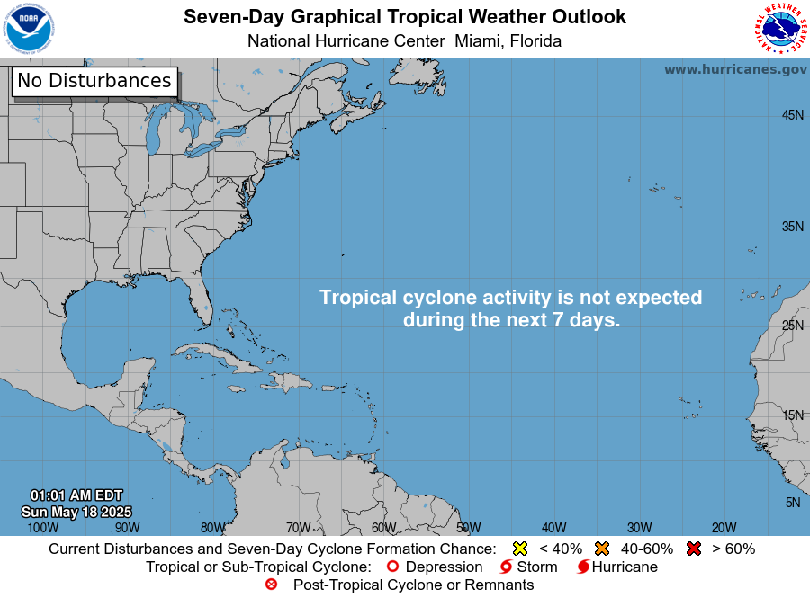
The Atlantic basin is quiet, with no active storms and no tropical cyclone formation expected over the next seven days.
- Active storms: none in the open Atlantic, the Caribbean Sea or the Gulf of Mexico.
- Threats to land: none. No tropical storm or hurricane watches or warnings are in effect.
- Disturbances: NHC is not tracking any areas for possible development.
- Season to date: 10 named storms, 1 hurricane and 1 major hurricane, below the 1991-2020 average for this date. The season ends November 30.
The National Hurricane Center and national weather services issue the official forecasts and warnings. If local officials order an evacuation, follow it immediately.
Active storms
There are no tropical or subtropical cyclones or potential tropical cyclones in the Atlantic basin. With no threat to land, this report has no storm-threat section today.
Disturbances to watch
NHC has no areas of interest in the Atlantic outlook. For the North Atlantic, the Caribbean Sea and the Gulf of Mexico, it states that “tropical cyclone formation is not expected during the next 7 days.”
Area | Location | 48-hour chance | 7-day chance | NHC outlook issued |
|---|
None | Whole Atlantic basin | No areas listed | No areas listed | 2:00 AM EDT Sat Oct 31 (06:00 UTC) |
The Tropical Weather Discussion issued at 0015 UTC lists no tropical waves and does not mention Saharan dust or wind shear. Its main features are non-tropical. A 1012 mb low northeast of Bermuda, near 33N 62W, has a cold front trailing to the waters north of the Turks and Caicos. A stationary front runs east from the low across the central Atlantic. North of these boundaries, fresh to strong winds are producing seas of 6 to 11 feet (1.8 to 3.4 m).
In the Caribbean, a surface trough from Jamaica to the north coast of Panama supports scattered moderate thunderstorms over the southwestern Caribbean. In the Gulf of Mexico, NHC expects a cold front to enter the northwest Gulf Tuesday night and reach the east-central Gulf Wednesday night.
Season so far
The 2026 Atlantic season is running below normal on every main count. NHC’s season summary, as of 03 UTC October 30, lists accumulated cyclone energy (ACE) of 19.5, which it puts at 83 percent below the 1991-2020 normal.
Measure | 2026 to date | 1991-2020 average by Oct 31 | 1991-2020 full-season average |
|---|
Named storms | 10 | 13 | 14 |
Hurricanes | 1 | 6 | 7 |
Major hurricanes (Category 3+) | 1 | 3 | 3 |
2026 counts are from the NHC 2026 Atlantic summary (as of 03 UTC October 30). Averages are from NHC climatology: the by-date figures use NHC’s table of the dates by which each storm normally forms (13th named storm by October 25, 6th hurricane by October 15, 3rd major hurricane by October 28).
The season’s only hurricane, Isaias, peaked at 105 knots (120 mph, 195 km/h) between October 6 and 10. The most recent system, Subtropical Storm Josephine, lasted from October 21 to 22.
ENSO: The NOAA Climate Prediction Center’s October 8 discussion keeps an El Niño Advisory in effect and says a strong-to-very strong El Niño is likely through January-March 2027.
What to watch next
- NHC Tropical Weather Outlook: the next issue is due around 8:00 AM EDT today, six hours after the 2:00 AM outlook, with updates through the day.
- Gulf of Mexico cold front: NHC’s marine forecast in the Tropical Weather Discussion expects it in the northwest Gulf Tuesday night and the east-central Gulf Wednesday night.
- Caribbean trade winds: NHC expects fresh to strong trades in the south-central Caribbean to ease basin-wide late Monday through Wednesday.
- ENSO update: the NOAA Climate Prediction Center’s next El Niño discussion is scheduled for November 12.
- End of season: the official Atlantic hurricane season runs through November 30, according to NHC.
About this report
This report summarizes official NHC products, NHC season statistics and climatology, and the NOAA Climate Prediction Center’s ENSO discussion. Times follow each product: NHC outlooks use Eastern Daylight Time (EDT), and the Tropical Weather Discussion uses UTC. Conditions can change between issues, so the newest NHC product always replaces the figures here. The Eastern and Central Pacific are covered in Orbis Weather’s separate Pacific reports.
Glossary
- Tropical wave: an elongated area of low pressure moving east to west across the tropics. Some develop into tropical storms.
- Potential tropical cyclone: a disturbance that is not yet a tropical cyclone but is expected to bring tropical-storm or hurricane conditions to land within 48 hours.
- Subtropical storm: a storm with features of both tropical and non-tropical systems, with winds of at least 39 mph (63 km/h).
- Saffir-Simpson category: a 1-to-5 hurricane scale based on sustained wind. Category 3 and above are major hurricanes.
- Accumulated cyclone energy (ACE): a measure of a season’s combined storm strength and duration.
Frequently asked questions
Is any hurricane or tropical storm threatening land today? No. There are no active tropical cyclones in the Atlantic, Caribbean or Gulf of Mexico, and no watches or warnings are in effect.
Could a storm form in the next week? NHC does not expect tropical cyclone formation in the basin during the next seven days. It reviews that outlook every six hours, so check the latest issue.
Is the hurricane season over? Not officially. The Atlantic season runs through November 30, so NHC continues to monitor the basin and issue outlooks until then.
How does 2026 compare with a normal season? It is below average for named storms, hurricanes and major hurricanes, and well below normal in overall storm energy. The Season so far table gives the counts.
Sources
- NHC Atlantic Tropical Weather Outlook, issued 2:00 AM EDT Sat Oct 31, 2026
- NHC Atlantic Tropical Weather Discussion, issued 0015 UTC Sat Oct 31, 2026
- National Hurricane Center home page, last updated 23:12 UTC Fri Oct 30, 2026
- NHC 2026 North Atlantic tropical cyclone summary, as of 03 UTC Oct 30, 2026
- NHC Tropical Cyclone Climatology, 1991-2020 averages (page undated)
- NOAA CPC ENSO Diagnostic Discussion, issued Oct 8, 2026